1999年伊茲密特地震
| 日期 | 1999年8月17日 |
|---|---|
| 發生時間 | 00:03:40 UTC+3[1] |
| 持續時間 | 37秒[2] |
| 震级 | 7.6 Mw[1][3] |
| 震源深度 | 15 km(9.3 mi)[1] |
| 震中 | 40°49′N 29°59′E / 40.81°N 29.98°E坐标:40°49′N 29°59′E / 40.81°N 29.98°E[1] |
| 類型 | 平移斷層[2] |
| 損失 | 3–8.5億USD[3] |
| 最大烈度 | IX[4] |
| 最大加速度 | .3–.4g[2] |
| 海嘯 | 2.52米(8英尺3英寸)[3] |
| 傷亡 | 17,118–17,127人死亡[3] 43,953–50,000人負傷[3] |
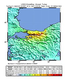
1999年伊茲密特地震又稱作科賈埃利地震或格爾居克地震,是一場發生於1999年8月17日清晨3點1分40秒的地震,震央在土耳其西北部科賈埃利省的首府伊茲密特。本地震的矩震級達到7.6,麥加利地震震度為9(IX)。37秒的搖晃造成超過17,000人死亡與50萬人無家可歸[5]。伊茲密特和鄰近城鎮均遭受嚴重的破壞。
概述[编辑]

本次地震肇因於北安那托利亞斷層西側的錯動。構成土耳其大部分領土的安那托利亞板塊每年受到北方歐亞大陸板塊及東南部的阿拉伯板塊擠壓而向西移動約2.5公分[6]。絕大部分土耳其地震都發生在北安那托利亞斷層和東安那托利亞斷層。
斷層沿著伊茲密特灣破裂,產生了從迪茲傑至馬摩拉海150公里(93英里)的破裂帶,及5.7公尺的地表偏移量[7]。
災情[编辑]
震央離伊斯坦堡僅70公里(43英里),給伊斯坦堡的人口稠密區帶來衝擊,工業方面亦造成包括數間發電廠、煉油廠及海軍基地的損失[2]。
根據當局於1999年10月9日發布的數據,共17,127人死亡及43,959人負傷,同時有部分非官方資料顯示死亡人數將近45,000人[5]。
此外,歐洲E80公路的20座橋梁及5條隧道無法行駛[8]。土耳其唯一的國有煉油廠Tüpraş的石腦油槽發生火警,5天後才得以撲滅[9]。

海嘯[编辑]
馬摩拉海因地震引發2.5公尺高的海嘯,造成155人喪生[10]。
救援行動[编辑]
匈牙利、以色列、法國、南韓、比利時、俄羅斯、德國、波蘭、希臘、奧地利、瑞士、美國、冰島、西班牙、埃及、英國、保加利亞、義大利、亞塞拜然、中華民國等國的救援團隊[11][12]、多家非政府組織及紅新月會大都在地震發生兩天內抵達災區展開搜救行動。
時任美國總統比爾·柯林頓及時任巴基斯坦總理納瓦茲·夏立夫都在地震發生後半年內前往重災區探視災民[13]。
參考文獻[编辑]
- ^ 1.0 1.1 1.2 1.3 ISC, ISC-GEM Global Instrumental Earthquake Catalogue (1900-2009), Version 1.05, International Seismological Centre, 2014 [2015-11-01], (原始内容存档于2016-11-25)
- ^ 2.0 2.1 2.2 2.3 Barka, A., The 17 August 1999 Izmit Earthquake, Science (American Association for the Advancement of Science), 1999, 285 (5435): 1858–1859 [2015-11-01], doi:10.1126/science.285.5435.1858, (原始内容存档于2015-09-24)
- ^ 3.0 3.1 3.2 3.3 3.4 USGS, PAGER-CAT Earthquake Catalog, Version 2008_06.1, United States Geological Survey, September 4, 2009 [2015-11-01], (原始内容存档于2015-03-28)
- ^ USGS, EXPO-CAT Earthquake Catalog, Version 2007-12, United States Geological Survey, December 1, 2008 [2015-11-01], (原始内容存档于2015-04-25)
- ^ 5.0 5.1 Marza, Vasile I. On the death toll of the 1999 Izmit (Turkey) major earthquake (PDF). ESC General Assembly Papers, Potsdam: European Seismological Commission. 2004 [5 March 2008]. (原始内容 (PDF)存档于2008-04-09).
- ^ USGS. Tectonic summary. Historic Earthquakes Magnitude 7.6 TURKEY 1999 August 17 00:01:39 UTC. June 18, 2012 [2 February 2013]. (原始内容存档于2015-09-29).
- ^ Reilinger, R.E.; Ergintav S., Bürgmann R., McClusky S., Lenk O., Barka A., Gurkan O., Hearn L., Feigl K.L., Cakmak R., Aktug B., Ozener H. & Töksoz M.N. Coseismic and Postseismic Fault Slip for the 17 August 1999, M = 7.5, Izmit, Turkey Earthquake (PDF). Science (American Association for the Advancement of Science). 2000, 289: 1519–1524 [2015-11-01]. doi:10.1126/science.289.5484.1519. (原始内容存档 (PDF)于2022-04-09).
- ^ Lusas software, "Seismic Assessment of the Mustafa Inan Viaduct" (页面存档备份,存于互联网档案馆)
- ^ Scawthorn, Eidinger, Schiff (编). Fire Following Earthquake. Reston, VA: ASCE, NFPA. 2005 [2015-11-01]. ISBN 9780784407394. (原始内容存档于2013-09-28).
- ^ National Geophysical Data Center. Tsunami event. [2 February 2013]. (原始内容存档于2021-01-07).
- ^ Tang, Alex K. (编). Izmit (Kocaeli), Turkey, earthquake of August 17, 1999 including Duzce Earthquake of November 12, 1999 Lifeline Performance. American Society of Civil Engineers. 2000: 259. ISBN 978-0-7844-0494-2.
- ^ Komenda Miejska Państwowej Straży Pożarnej w Nowym Sączu. [2015-11-01]. (原始内容存档于2020-09-02).
- ^ Bill Clinton visits İzmit,Turkey. [2015-11-01]. (原始内容存档于2021-01-08).
外部連結[编辑]
| 维基共享资源中相关的多媒体资源:1999年伊茲密特地震 |
- (英文)M7.6-土耳其西部(页面存档备份,存于互联网档案馆)-美國地質調查局
- (英文)1999年8月17日伊茲密特地震(页面存档备份,存于互联网档案馆)-歐洲地震工程學會
- (英文)1999年8月17日伊茲密特地震中岩土工程初步觀察-國家地震工程資訊機構
| ||||||||||||

