
File:11-E 2010 track.png

本预览的尺寸:800 × 495像素。 其他分辨率:320 × 198像素 | 640 × 396像素 | 1,024 × 633像素。
原始文件 (1,024 × 633像素,文件大小:398 KB,MIME类型:image/png)
摘要
| 描述 |
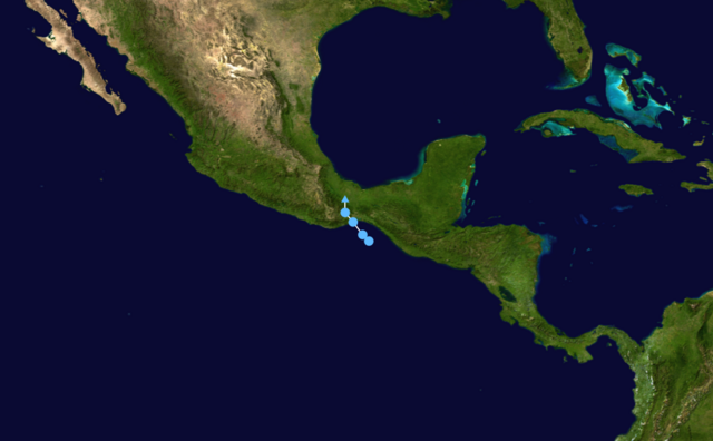
English: Track map of Tropical Depression 11-E of the 2010 Pacific hurricane season. The points show the location of the storm at 6-hour intervals. The colour represents the storm's maximum sustained wind speeds as classified in the Saffir-Simpson Hurricane Scale (see below), and the shape of the data points represent the nature of the storm, according to the legend below.
Tropical depression (≤38 mph, ≤62 km/h)
Tropical storm (39–73 mph, 63–118 km/h)
Category 1 (74–95 mph, 119–153 km/h)
Category 2 (96–110 mph, 154–177 km/h)
Category 3 (111–129 mph, 178–208 km/h)
Category 4 (130–156 mph, 209–251 km/h)
Category 5 (≥157 mph, ≥252 km/h)
Unknown
Storm type |
| 日期 | |
| 来源 | Created by Syntheticalconnections using Wikipedia:WikiProject Tropical cyclones/Tracks. The background image is from NASA. Tracking data is from the Joint Typhoon Warning Center. |
| 作者 | Syntheticalconnections |
许可协议
我,本作品著作权人,特此采用以下许可协议发表本作品:
本文件采用知识共享署名-相同方式共享 3.0 未本地化版本许可协议授权。
- 您可以自由地:
- 共享 – 复制、发行并传播本作品
- 修改 – 改编作品
- 惟须遵守下列条件:
- 署名 – 您必须对作品进行署名,提供授权条款的链接,并说明是否对原始内容进行了更改。您可以用任何合理的方式来署名,但不得以任何方式表明许可人认可您或您的使用。
- 相同方式共享 – 如果您再混合、转换或者基于本作品进行创作,您必须以与原先许可协议相同或相兼容的许可协议分发您贡献的作品。
文件历史
点击某个日期/时间查看对应时刻的文件。
| 日期/时间 | 缩略图 | 大小 | 用户 | 备注 | |
|---|---|---|---|---|---|
| 当前 | 2010年11月23日 (二) 21:23 | | 1,024 × 633(398 KB) | Cyclonebiskit | updated |
| 2010年9月5日 (日) 22:06 |  | 1,024 × 633(395 KB) | Syntheticalconnections | {{Information |Description={{en|1={{Information |Description={{en|Track map of Tropical Depression 11-E of the 2010 Pacific hurricane season. The points s |
文件用途
以下页面使用本文件:
全域文件用途
以下其他wiki使用此文件:
- de.wikipedia.org上的用途
- es.wikipedia.org上的用途
- ko.wikipedia.org上的用途
- simple.wikipedia.org上的用途