
File:Climograma Santiago.png
此为最大尺寸。
Climograma_Santiago.png (450 × 450像素,文件大小:11 KB,MIME类型:image/png)
摘要
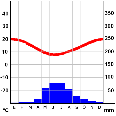
Climograma de Santiago de Chile (Pudahuel)
- Ubicación: 33º23' S 70º47' W
- Altura: 475 msnm
许可协议
Climograma basado en el realizado por Klimadiagramm archive copy at the Wayback Machine creado por Homeruniverse, cuyos archivos pertenecen al dominio público
Note: This tag is deprecated, please replace this template with {{PD-user-w}}
| |
本作品已被作者德语维基百科项目的Homeruniverse释出到公有领域。这适用于全世界。 如果这样做不合法的话: |
| 註解 | 該圖片含有註解:在維基媒體共享資源上查看註解 |
文件历史
点击某个日期/时间查看对应时刻的文件。
| 日期/时间 | 缩略图 | 大小 | 用户 | 备注 | |
|---|---|---|---|---|---|
| 当前 | 2006年1月26日 (四) 04:26 | | 450 × 450(11 KB) | B1mbo | Santiago Category:Santiago de Chile Climograma de Santiago de Chile (Pudahuel) *Ubicación: 33º23' S 70º47' W *Altura: 475 msnm ==Licensing== Climograma basado en el realizado por [http://homeruniverse.n� |
文件用途
以下页面使用本文件:
全域文件用途
以下其他wiki使用此文件:
- ca.wikipedia.org上的用途
- crh.wikipedia.org上的用途
- diq.wikipedia.org上的用途
- es.wikipedia.org上的用途
- es.wikivoyage.org上的用途
- fi.wikipedia.org上的用途
- fr.wikipedia.org上的用途
- gl.wikipedia.org上的用途
- hu.wikipedia.org上的用途
- id.wikipedia.org上的用途
- ja.wikibooks.org上的用途
- pl.wikipedia.org上的用途
- pt.wikipedia.org上的用途
- sq.wikipedia.org上的用途
- zh-classical.wikipedia.org上的用途