
File:Javier 2004-09-13 2040Z.jpg

本预览的尺寸:450 × 600像素。 其他分辨率:180 × 240像素 | 360 × 480像素 | 576 × 768像素 | 768 × 1,024像素 | 1,536 × 2,048像素 | 6,001 × 8,001像素。
原始文件 (6,001 × 8,001像素,文件大小:8.46 MB,MIME类型:image/jpeg)
摘要
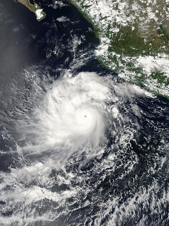
| 描述 | The MODIS instrument flying aboard NASA's Aqua satellite captured this true-color image of Hurricane Javier on September 13, 2004 at 20:40 UTC (4:40 PM EDT). At the time this image was taken Javier was located approximately 982 km (610 miles) southeast of Cabo San Lucas, Mexico and was moving towards the northwest at 15 km/hr (9 mph). Maximum sustained winds were near 222 km/hr (138 mph) with higher gusts to 269 km/hr (167 mph). | |||||
| 日期 | ||||||
| 来源 | http://earthobservatory.nasa.gov/NaturalHazards/natural_hazards_v2.php3?img_id=12435 | |||||
| 作者 | NASA image created by Jesse Allen, Earth Observatory, from data provided by the MODIS Rapid Response team. | |||||
| 授权 (二次使用本文件) |
|

文件历史
点击某个日期/时间查看对应时刻的文件。
| 日期/时间 | 缩略图 | 大小 | 用户 | 备注 | |
|---|---|---|---|---|---|
| 当前 | 2018年12月3日 (一) 22:29 | | 6,001 × 8,001(8.46 MB) | FleurDeOdile | worldview |
| 2006年8月20日 (日) 22:29 |  | 4,000 × 4,000(2.56 MB) | Good kitty | {{Information |Description=The MODIS instrument flying aboard NASA's Aqua satellite captured this true-color image of Hurricane Javier on September 13, 2004 at 20:40 UTC (4:40 PM EDT). At the time this image was taken Javier was located approximately 982 |
文件用途
以下2个页面使用本文件:
全域文件用途
以下其他wiki使用此文件:
- de.wikipedia.org上的用途
- en.wikipedia.org上的用途
- pt.wikipedia.org上的用途
- simple.wikipedia.org上的用途
- vi.wikipedia.org上的用途
- www.wikidata.org上的用途