
File:LocationNSAmUNGeoscheme.png

本预览的尺寸:600 × 600像素。 其他分辨率:240 × 240像素 | 480 × 480像素。
原始文件 (800 × 800像素,文件大小:22 KB,MIME类型:image/png)
摘要
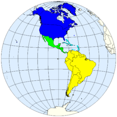
| 描述 | United Nations geoscheme for the Americas. |
| 日期 | |
| 来源 | prepared from public domain maps created by w:en:User:E Pluribus Anthony. |
| 作者 | Spacepotato |
Legend
- 0000FF: Northern America.
- 00FF00: Central America.
- 00FFFF: Caribbean.
- FFFC00: South America.
References
- Composition of macro geographical (continental) regions, geographical sub-regions, and selected economic and other groupings. United Nations Statistics Division, Country and Region Codes. Revised August 28, 2007. Accessed on line October 12, 2007.
许可协议
| 我,本作品著作权人,释出本作品至公有领域。这适用于全世界。 在一些国家这可能不合法;如果是这样的话,那么: 我无条件地授予任何人以任何目的使用本作品的权利,除非这些条件是法律规定所必需的。 |
See also
- Image:LocationNSAm.png
- Image:LocationNSAm2.png
- Image:LocationNSAm3.png
- Image:LocationNSAngloLatin.png
文件历史
点击某个日期/时间查看对应时刻的文件。
| 日期/时间 | 缩略图 | 大小 | 用户 | 备注 | |
|---|---|---|---|---|---|
| 当前 | 2007年10月12日 (五) 19:02 | | 800 × 800(22 KB) | Spacepotato | == Summary == {{Information |Description=United Nations geoscheme for the Americas. |Source=prepared from public domain maps created by w:en:User:E Pluribus Anthony. |Date=October 12, 2007. |Author= Spacepotato }} ==Legend== {{leg |
文件用途
以下页面使用本文件:
全域文件用途
以下其他wiki使用此文件:
- bn.wikipedia.org上的用途
- en.wikipedia.org上的用途
- es.wikipedia.org上的用途
- fr.wikipedia.org上的用途
- id.wikipedia.org上的用途
- it.wikipedia.org上的用途
- ja.wikipedia.org上的用途
- kaa.wikipedia.org上的用途
- kg.wikipedia.org上的用途
- ky.wikipedia.org上的用途
- mn.wikipedia.org上的用途
- pl.wikipedia.org上的用途
- pnb.wikipedia.org上的用途
- ru.wikipedia.org上的用途
- sr.wikipedia.org上的用途
- th.wikipedia.org上的用途
- ur.wikipedia.org上的用途
- vep.wikipedia.org上的用途