
File:Location of the BOTs.svg

此SVG文件的PNG预览的大小:735 × 433像素。 其他分辨率:320 × 189像素 | 640 × 377像素 | 1,024 × 603像素 | 1,280 × 754像素 | 2,560 × 1,508像素。
原始文件 (SVG文件,尺寸为735 × 433像素,文件大小:1.28 MB)
摘要
| 描述 |
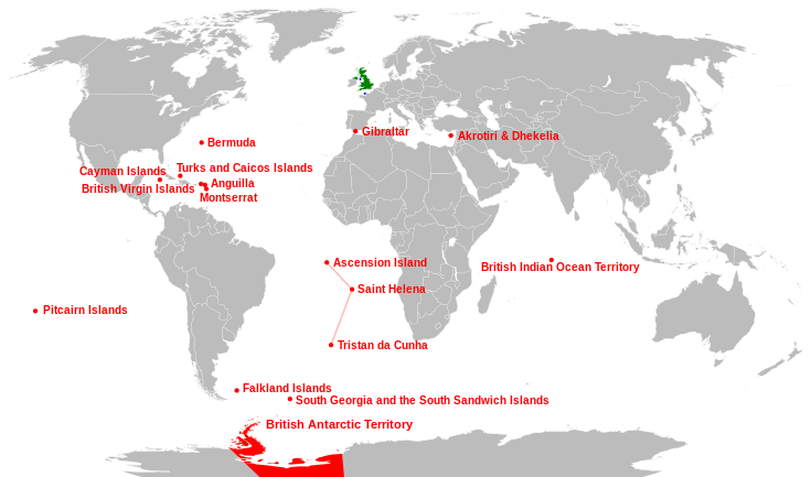
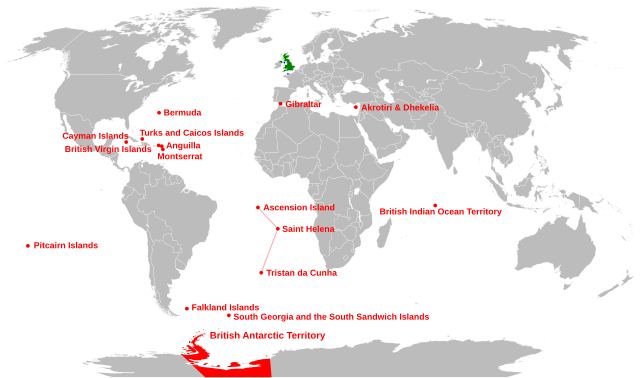
English: Location of the British Overseas Territories (red), Crown dependencies (blue), and Great Britain and Northern Ireland (green) |
| 日期 | |
| 来源 |
本檔案衍生自: |
| 作者 | Richardprins |
| 其他版本 |
此文件衍生的作品: |
| SVG开发 |


许可协议
| 我,本作品著作权人,释出本作品至公有领域。这适用于全世界。 在一些国家这可能不合法;如果是这样的话,那么: 我无条件地授予任何人以任何目的使用本作品的权利,除非这些条件是法律规定所必需的。 |
文件历史
点击某个日期/时间查看对应时刻的文件。
| 日期/时间 | 缩略图 | 大小 | 用户 | 备注 | |
|---|---|---|---|---|---|
| 当前 | 2015年4月29日 (三) 07:01 | | 735 × 433(1.28 MB) | Carnby | South Sudan border |
| 2011年1月24日 (一) 22:23 |  | 735 × 433(1.26 MB) | Malus Catulus | fixed country borders | |
| 2011年1月23日 (日) 15:37 |  | 735 × 433(1.28 MB) | Malus Catulus | typo fix and pitcairn location fix | |
| 2011年1月23日 (日) 15:15 |  | 735 × 433(1.28 MB) | Malus Catulus | Changed font size of Antartic... | |
| 2011年1月23日 (日) 15:03 |  | 735 × 433(1.28 MB) | Malus Catulus | Faulty text be fixed, yarrr | |
| 2011年1月23日 (日) 12:48 |  | 735 × 433(1.26 MB) | Malus Catulus | Minor corrections | |
| 2011年1月22日 (六) 16:20 |  | 735 × 433(1.26 MB) | Malus Catulus | few adjustments, corrected Atlantic Ocean Islands | |
| 2010年10月1日 (五) 06:30 |  | 735 × 433(1.21 MB) | Pfly | Attempt to improve graphics of previous edit fix | |
| 2010年10月1日 (五) 06:23 |  | 735 × 433(1.21 MB) | Pfly | Moved British Indian Ocean Territory to correct location. | |
| 2010年7月20日 (二) 19:42 |  | 735 × 433(1.41 MB) | Malus Catulus | fixes + white background |
文件用途
以下5个页面使用本文件:
全域文件用途
以下其他wiki使用此文件:
- af.wikipedia.org上的用途
- an.wikipedia.org上的用途
- ast.wikipedia.org上的用途
- azb.wikipedia.org上的用途
- az.wikipedia.org上的用途
- br.wikipedia.org上的用途
- ca.wikipedia.org上的用途
- cs.wikipedia.org上的用途
- da.wikipedia.org上的用途
- de.wikipedia.org上的用途
- el.wikipedia.org上的用途
- en.wikipedia.org上的用途
- es.wikipedia.org上的用途
- eu.wikipedia.org上的用途
- Erresuma Batua
- Ingalaterra
- Eskozia
- Gibraltar
- Ipar Irlanda
- Gales
- Ascension
- Santa Helena
- Falklandak
- Man
- Jersey
- Guernesey
- Hegoaldeko Georgiak
- Pitcairn uharteak
- Hegoaldeko Sandwichak
- Hegoaldeko Georgiak eta Hegoaldeko Sandwichak
- Birjina britainiar uharteak
- Bermuda
- Kaiman uharteak
- Montserrat (uhartea)
- Turkak eta Caicoak
- Aingira (dependentzia)
- Txantiloi:Erresuma Batuko lurralde antolaketa
- Akrotiri eta Dhekelia
- Britainiar koroaren dependentzia
查看本文件的更多全域用途。