
File:Map of the Faroe Islands en.svg

此SVG文件的PNG预览的大小:457 × 600像素。 其他分辨率:183 × 240像素 | 366 × 480像素 | 585 × 768像素 | 780 × 1,024像素 | 1,561 × 2,048像素 | 1,683 × 2,208像素。
原始文件 (SVG文件,尺寸为1,683 × 2,208像素,文件大小:763 KB)
摘要
| 描述 |
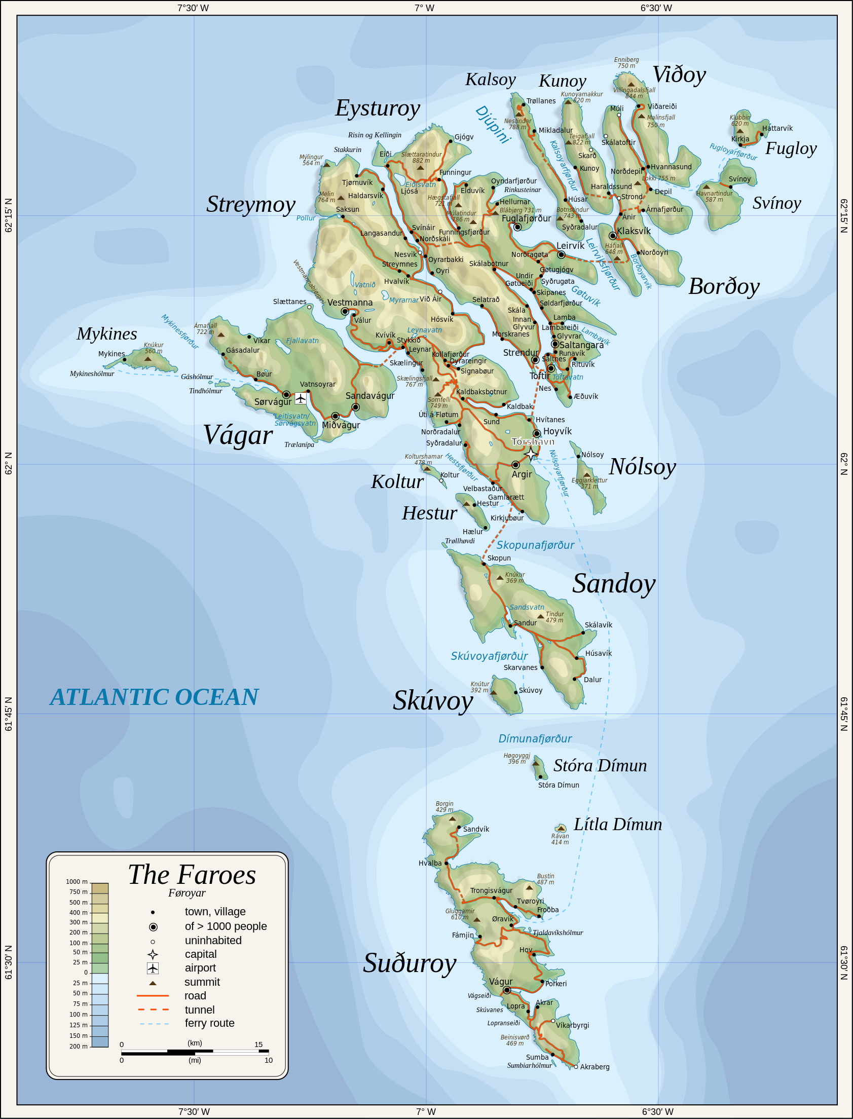
English: Topographic map of the Faroe Islands.
Suomi: Färsaarten topografinen kartta.
Coastline, roads, place names, and summits based partly on File:Faroe map with villages, streets, straits, firths, ferry harbours and major moutains.png. Topography based on public domain GLOBE data from NOAA (http://www.ngdc.noaa.gov/mgg/topo/gltiles.html). Relief shading is an embedded PNG raster, derived from ETOPO2 data. Bathymetry from NGDC ETOPO2 (low resolution raster with a "blur" property). |
| 日期 | 2009-01-28, 2024-02-11 |
| 来源 | 自己的作品 |
| 作者 | Oona Räisänen |
| 其他版本 |
此文件衍生的作品: |
| SVG开发 | 此SVG 文件使用了内嵌文本,可以使用任何文本编辑器轻松翻译。 |
许可协议
Oona Räisänen (Mysid),本作品著作权人,特此采用以下许可协议发表本作品:
本文件采用知识共享署名-相同方式共享 3.0 未本地化版本许可协议授权。
署名: Oona Räisänen (Mysid)
- 您可以自由地:
- 共享 – 复制、发行并传播本作品
- 修改 – 改编作品
- 惟须遵守下列条件:
- 署名 – 您必须对作品进行署名,提供授权条款的链接,并说明是否对原始内容进行了更改。您可以用任何合理的方式来署名,但不得以任何方式表明许可人认可您或您的使用。
- 相同方式共享 – 如果您再混合、转换或者基于本作品进行创作,您必须以与原先许可协议相同或相兼容的许可协议分发您贡献的作品。

|
已授权您依据自由软件基金会发行的无固定段落及封面封底文字(Invariant Sections, Front-Cover Texts, and Back-Cover Texts)的GNU自由文件许可协议1.2版或任意后续版本的条款,复制、传播和/或修改本文件。该协议的副本请见“GNU Free Documentation License”。 |
您可以选择您需要的许可协议。
文件历史
点击某个日期/时间查看对应时刻的文件。
| 日期/时间 | 缩略图 | 大小 | 用户 | 备注 | |
|---|---|---|---|---|---|
| 当前 | 2024年2月11日 (日) 20:53 | | 1,683 × 2,208(763 KB) | Mysid | 'Multiply' blend mode didn't work - trying with alpha channel. |
| 2024年2月11日 (日) 20:34 |  | 1,683 × 2,208(733 KB) | Mysid | Added new 2023 tunnel, new names of some villages, fixed mistakes and svg errors, details | |
| 2010年7月19日 (一) 09:18 |  | 1,683 × 2,208(539 KB) | Mysid | oops, legend missing | |
| 2010年7月19日 (一) 09:16 |  | 1,683 × 2,208(539 KB) | Mysid | better choices for fonts | |
| 2009年1月28日 (三) 19:22 |  | 1,683 × 2,208(694 KB) | Mysid | remove ext. images | |
| 2009年1月28日 (三) 19:21 |  | 1,683 × 2,208(694 KB) | Mysid | embed all rasters | |
| 2009年1月28日 (三) 18:52 |  | 1,683 × 2,208(653 KB) | Mysid | {{Information |Description={{en|1=Topographic map of the Faroe Islands.}} |Source=Own work by uploader |Author=Mysid |Date=2009-01-28 |Permission= |other_versions= }} <!--{{ImageUpload|full}}--> Category:Maps of the Faroe Islands |
文件用途
全域文件用途
以下其他wiki使用此文件:
- bg.wikipedia.org上的用途
- bn.wikipedia.org上的用途
- dsb.wikipedia.org上的用途
- el.wikipedia.org上的用途
- en.wikipedia.org上的用途
- es.wikipedia.org上的用途
- fa.wikipedia.org上的用途
- fi.wikipedia.org上的用途
- fo.wikipedia.org上的用途
- frr.wikipedia.org上的用途
- fr.wikipedia.org上的用途
- ga.wikipedia.org上的用途
- hu.wikipedia.org上的用途
- ia.wikipedia.org上的用途
- is.wikipedia.org上的用途
- it.wikipedia.org上的用途
- ka.wikipedia.org上的用途
- kk.wikipedia.org上的用途
- ko.wikipedia.org上的用途
- lb.wikipedia.org上的用途
- lez.wikipedia.org上的用途
- mi.wikipedia.org上的用途
- mk.wikipedia.org上的用途
- nl.wikipedia.org上的用途
- ru.wikipedia.org上的用途
- scn.wikipedia.org上的用途
- sco.wikipedia.org上的用途
- sc.wikipedia.org上的用途
- sr.wikipedia.org上的用途
- sv.wikipedia.org上的用途
查看本文件的更多全域用途。