
File:Merc fig2sm.jpg
此为最大尺寸。
Merc_fig2sm.jpg (360 × 400像素,文件大小:37 KB,MIME类型:image/jpeg)
摘要
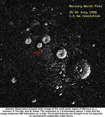
| 描述 | Arecibo Observatory S-band radar image of the north polar region of Mercury by J. Harmon, P. Perrilat and M. Slade. The resolution is 1.5 km (about 1 mile) and the image measures 450 km on a side. The bright features are thought to be ice deposits on permanently shadowed crater floors. Acquired 25-26 July 1999. |
| 日期 | 25-26 July 1999 |
| 来源 | [1] from [2] on SCIENCE@NASA |
| 作者 | NASA photo |
| 授权 (二次使用本文件) |
Quote from [3]: "All information on this site is public domain...." |
![[1]](http://science.nasa.gov/headlines/y2006/images/mercury/merc_fig2sm.jpg)
许可协议
| 本文件完全由NASA创作,在美国属于公有领域。根据NASA的版权方针,NASA的材料除非另有声明否则不受版权保护。(参见Template:PD-USGov/zh、NASA版权方针页面或JPL图片使用方针。) | ||
 |
警告:
|
文件历史
点击某个日期/时间查看对应时刻的文件。
| 日期/时间 | 缩略图 | 大小 | 用户 | 备注 | |
|---|---|---|---|---|---|
| 当前 | 2020年3月3日 (二) 03:08 | | 360 × 400(37 KB) | Jstuby | Reverted to version as of 11:48, 16 April 2006 (UTC) |
| 2012年9月23日 (日) 12:53 |  | 360 × 367(155 KB) | Soerfm | Crop, sharpen | |
| 2006年4月16日 (日) 11:48 |  | 360 × 400(37 KB) | Honeplus | {{Information| |Description= Quote from [http://spacescience.com/headlines/y2006/4review_mercury.htm]: "''An Mercury's north pole...''" |Source= [http://spacescience.com/headlines/y2006/images/mercury/merc_fig2sm.jpg] from [http://spacescience.com/headl |
文件用途
全域文件用途
以下其他wiki使用此文件:
- ar.wikipedia.org上的用途
- azb.wikipedia.org上的用途
- az.wikipedia.org上的用途
- be.wikipedia.org上的用途
- bg.wikipedia.org上的用途
- bn.wikipedia.org上的用途
- ca.wikipedia.org上的用途
- da.wikipedia.org上的用途
- de.wikipedia.org上的用途
- en.wikipedia.org上的用途
- en.wikiversity.org上的用途
- es.wikipedia.org上的用途
- fa.wikipedia.org上的用途
- fr.wikipedia.org上的用途
- hi.wikipedia.org上的用途
- hu.wikipedia.org上的用途
- hy.wikipedia.org上的用途
- it.wikipedia.org上的用途
- ja.wikipedia.org上的用途
- ko.wikipedia.org上的用途
- la.wikipedia.org上的用途
- lv.wikipedia.org上的用途
- mk.wikipedia.org上的用途
- ml.wikipedia.org上的用途
- nds.wikipedia.org上的用途
- no.wikipedia.org上的用途
- pl.wikipedia.org上的用途
- pt.wikipedia.org上的用途
- ro.wikipedia.org上的用途
- ru.wikipedia.org上的用途
查看本文件的更多全域用途。