
File:Partition of Hungary.png
此为最大尺寸。
Partition_of_Hungary.png (389 × 328像素,文件大小:31 KB,MIME类型:image/png)
摘要

| 描述 |
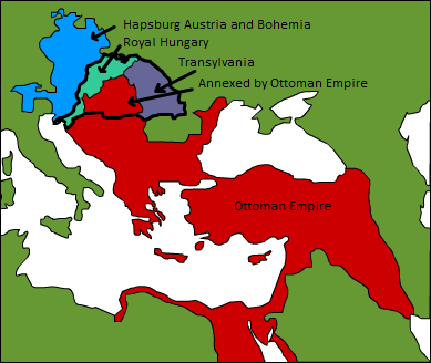
A map displaying position of the Kingdom of Hungary before 1541, and the 3 parts into which it was divided after the occupation of Buda in 1541: Royal Hungary, Eastern Hungarian kingdom, and the part that was annexed by the Ottoman Empire. en:Category:Maps of the history of Hungary |
| 日期 | 2006年9月3日 (原始上传日期) |
| 来源 | 本檔案是從en.wikipedia轉移到維基共享資源。 |
| 作者 | Later versions were uploaded by PANONIAN, DonatusHR at en.wikipedia. |
许可协议
| 本作品已被作者英语维基百科的Esoltas释出到公有领域。这适用于全世界。 在一些国家这可能不合法;如果是这样的话,那么: Esoltas无条件地授予任何人以任何目的使用本作品的权利,除非这些条件是法律规定所必需的。 |
原始上传日志
原始描述頁面位於這裡。下列使用者名稱均來自en.wikipedia。
- 2007-08-12 15:14 DonatusHR 389×328×8 (38357 bytes) Vraćeno na prijašnju inačicu
- 2007-08-12 15:13 DonatusHR 389×328×8 (35596 bytes) Vraćeno na prijašnju inačicu
- 2006-10-11 10:58 PANONIAN 389×328×8 (38357 bytes) corrected image
- 2006-09-03 15:00 Esoltas 389×328×8 (35596 bytes) A map displaying the original position of the Kingdom of Hungary, and the 3 lands that became of it after the Battle of Mohács: Royal Hungary, Transylvania, and the Ottoman-occupied section.
文件历史
点击某个日期/时间查看对应时刻的文件。
| 日期/时间 | 缩略图 | 大小 | 用户 | 备注 | |
|---|---|---|---|---|---|
| 当前 | 2016年2月12日 (五) 17:22 | | 389 × 328(31 KB) | Packare | better caption |
| 2007年9月10日 (一) 17:58 |  | 389 × 328(37 KB) | Sir Iain | {{Information |Description=A map displaying position of the Kingdom of Hungary before 1526, and the 3 parts into which it was divided after the Battle of Mohács: Royal Hungary, Transylvania, and the part that was annexed by the Ottoman Empire. [[:en:Ca |
文件用途
以下17个页面使用本文件:
全域文件用途
以下其他wiki使用此文件:
- ar.wikipedia.org上的用途
- azb.wikipedia.org上的用途
- de.wikipedia.org上的用途
- el.wikipedia.org上的用途
- en.wikipedia.org上的用途
- es.wikipedia.org上的用途
- fr.wikipedia.org上的用途
- gl.wikipedia.org上的用途
- hu.wikipedia.org上的用途
- io.wikipedia.org上的用途
- it.wikipedia.org上的用途
- ja.wikipedia.org上的用途
- ko.wikipedia.org上的用途
- lv.wikipedia.org上的用途
- nl.wikipedia.org上的用途
- sk.wikipedia.org上的用途
- trv.wikipedia.org上的用途
- tr.wikipedia.org上的用途
- uk.wikipedia.org上的用途
- uz.wikipedia.org上的用途