
File:The Danube Spills into the Black Sea.jpg

本预览的尺寸:669 × 600像素。 其他分辨率:268 × 240像素 | 535 × 480像素 | 857 × 768像素 | 1,142 × 1,024像素 | 2,080 × 1,865像素。
原始文件 (2,080 × 1,865像素,文件大小:1.07 MB,MIME类型:image/jpeg)
摘要
| 描述 |
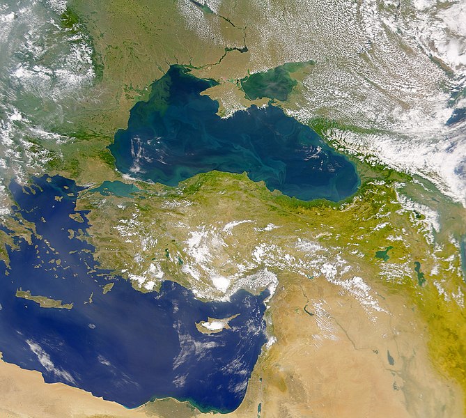
English: This cloud-free Sea-viewing Wide Field-of-view Sensor (SeaWiFS) view of the Black Sea reveals the colourful interplay of currents on the lake’s surface. The green crescent shaped pattern in the north-western corner of the Black Sea is due to the nutrient-rich, sediment-laden discharge of the Danube River stimulating biological activity. The brighter, more turquoise patterns on the lake to the south and east are probably blooms of another type of phytoplankton. |
| 日期 | |
| 来源 | NASA Earth Observatory |
| 作者 | The SeaWiFS Project |
Image courtesy of the NASA/Goddard Space Flight Center, and ORBIMAGE.
许可协议
| 本文件完全由NASA创作,在美国属于公有领域。根据NASA的版权方针,NASA的材料除非另有声明否则不受版权保护。(参见Template:PD-USGov/zh、NASA版权方针页面或JPL图片使用方针。) | ||
 |
警告:
|
文件历史
点击某个日期/时间查看对应时刻的文件。
| 日期/时间 | 缩略图 | 大小 | 用户 | 备注 | |
|---|---|---|---|---|---|
| 当前 | 2010年4月20日 (二) 11:20 | | 2,080 × 1,865(1.07 MB) | Originalwana | {{Information |Description={{en|1=This cloud-free Sea-viewing Wide Field-of-view Sensor (SeaWiFS) view of the Black Sea reveals the colourful interplay of currents on the lake’s surface. The green crescent shaped pattern in the north-western cor |
文件用途
全域文件用途
以下其他wiki使用此文件:
- ady.wikipedia.org上的用途
- crh.wikipedia.org上的用途
- en.wikipedia.org上的用途
- eo.wikipedia.org上的用途
- fr.wikipedia.org上的用途
- gu.wikipedia.org上的用途
- hak.wikipedia.org上的用途
- hr.wikipedia.org上的用途
- hu.wikipedia.org上的用途
- ilo.wikipedia.org上的用途
- ja.wikipedia.org上的用途
- kn.wikipedia.org上的用途
- lg.wikipedia.org上的用途
- pl.wikipedia.org上的用途
- rm.wikipedia.org上的用途
- sr.wikipedia.org上的用途
- ta.wikipedia.org上的用途
- uk.wikipedia.org上的用途
- vi.wikipedia.org上的用途
- wuu.wikipedia.org上的用途