
File:Battle of whitemarsh view.jpg

本预览的尺寸:800 × 541像素。 其他分辨率:320 × 217像素 | 640 × 433像素 | 851 × 576像素。
原始文件 (851 × 576像素,文件大小:130 KB,MIME类型:image/jpeg)
摘要
| 描述 |
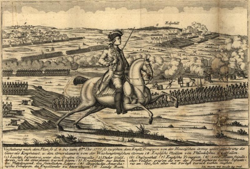
View from the British positions at the en:Battle of White Marsh. Chestnut Hill is in the lower left of the image, Sandy Run in the upper left, and Edge Hill in the upper right. Vorstellung nach dem Plan so d. 4. bis zum 8ten Dec. 1777 so zwischen dem Engl. Trouppen von der Howeischen Armee unter Anführung des Generals Kniphausē u. den Amerikanern von der Washingtonischen Armee 14 englische Meilen von Philadelphia vergefallen... |
| 日期 | 2006年9月22日 (原始上传日期) |
| 来源 | Library of Congress, Geography and Map Division. <http://hdl.loc.gov/loc.gmd/g3821sm.gas00001> (via en.wikipedia; description page is/was here). |
| 作者 | By Johann Martin Will. Map. Augsburg, Germany: ?, 1777 |
许可协议
|
本作品在其来源国以及其他著作权期限是作者逝世后70年或以下的国家和地区属于公有领域。
| |
| 本文件已被确认为免除已知的著作权法限制(包括所有相关权利)。 | |
原始上传日志
(All user names refer to en.wikipedia)
- 2006-09-22 22:53 Alphageekpa 851×576×8 (133411 bytes) == Summary == View from the British positions at the [[Battle of White Marsh]]. Chestnut Hill is in the lower left of the image, Sandy Run in the upper left, and Edge Hill in the upper right. ''Vorstellung nach dem Plan so d. 4. bis zum 8ten Dec. 1777 s
文件历史
点击某个日期/时间查看对应时刻的文件。
| 日期/时间 | 缩略图 | 大小 | 用户 | 备注 | |
|---|---|---|---|---|---|
| 当前 | 2007年10月20日 (六) 16:18 | | 851 × 576(130 KB) | Fryed-peach | {{Information |Description=View from the British positions at the en:Battle of White Marsh. Chestnut Hill is in the lower left of the image, Sandy Run in the upper left, and Edge Hill in the upper right. ''Vorstellung nach dem Plan so d. 4. bis zum |
文件用途
以下页面使用本文件:
全域文件用途
以下其他wiki使用此文件:
- en.wikipedia.org上的用途
- fr.wikipedia.org上的用途
- ja.wikipedia.org上的用途
- ko.wikipedia.org上的用途
- ru.wikipedia.org上的用途
- tl.wikipedia.org上的用途
- www.wikidata.org上的用途