File:EdwardWright-MapforSailingtoAzores-1599.jpg

页面内容不支持其他语言。
這個文件來自維基共享資源
维基百科,自由的百科全书

EdwardWright-MapforSailingtoAzores-1599.jpg(477 × 518像素,文件大小:96 KB,MIME类型:image/jpeg


摘要

描述
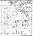
English: English mathematician and cartographer Edward Wright's map "for sailing to the Isles of Azores", which was constructed according to the Mercator projection which Wright explained in his work Certaine Errors of Navigation (1599). The star-like grid of lines are loxodromes or rhumb lines.
日期
来源 Edward Wright (1599年) 《 Certaine Errors in Navigation, arising either of the Ordinarie Erroneous Making or Vsing of the Sea Chart, Compasse, Crosse Staffe, and Tables of Declination of the Sunne, and Fixed Starres Detected and Corrected. (The Voyage of the Right Ho. George Earle of Cumberl. to the Azores, &c.)》、​倫敦: Printed ... by Valentine Simmes Reproduced as fig. 2.10 of Paul J. Lewi (2006-02-11) "Mercator, Wright and Mapmaking" inSpeaking of Graphics: An Essay on Graphicacy in Science, Technology and Business》、​Turnhout, Belgium: DataScope、​pp. 30
作者 Edward Wright

许可协议

Public domain

本作品在其来源国以及其他著作权期限是作者逝世后100年或以下的国家和地区属于公有领域


你必须增加美国公有领域标签显示为何这个作品在美国属于公有领域。

说明

添加一行文字以描述该文件所表现的内容

此文件中描述的项目

描繪內容

image/jpeg

文件历史

点击某个日期/时间查看对应时刻的文件。

日期/时间缩⁠略⁠图大小用户备注
当前2008年5月5日 (一) 16:452008年5月5日 (一) 16:45版本的缩略图477 × 518(96 KB)Jacklee==Summary== {{Information |Description = {{en|English mathematician and cartographer Edward Wright's map "for sailing to the Isles of Azores", which wa

以下页面使用本文件:

全域文件用途

以下其他wiki使用此文件:

元数据