
File:Florida topographic map-en.svg

此SVG文件的PNG预览的大小:617 × 600像素。 其他分辨率:247 × 240像素 | 494 × 480像素 | 790 × 768像素 | 1,053 × 1,024像素 | 2,106 × 2,048像素 | 2,890 × 2,810像素。
原始文件 (SVG文件,尺寸为2,890 × 2,810像素,文件大小:2.51 MB)
|

摘要
| 描写 |
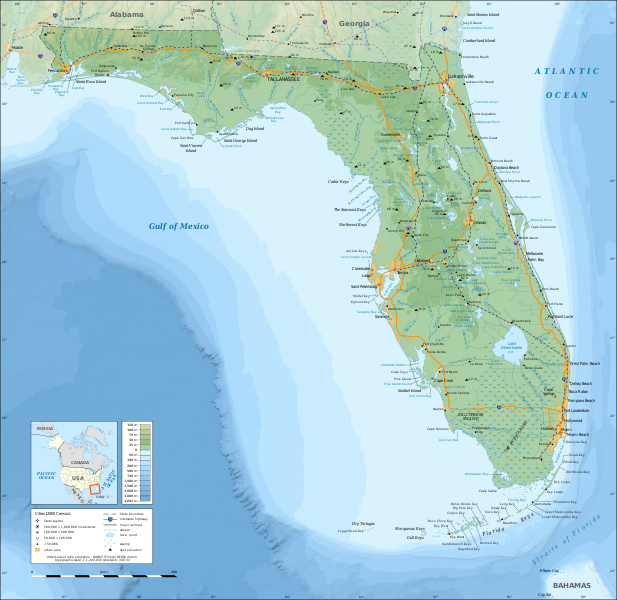
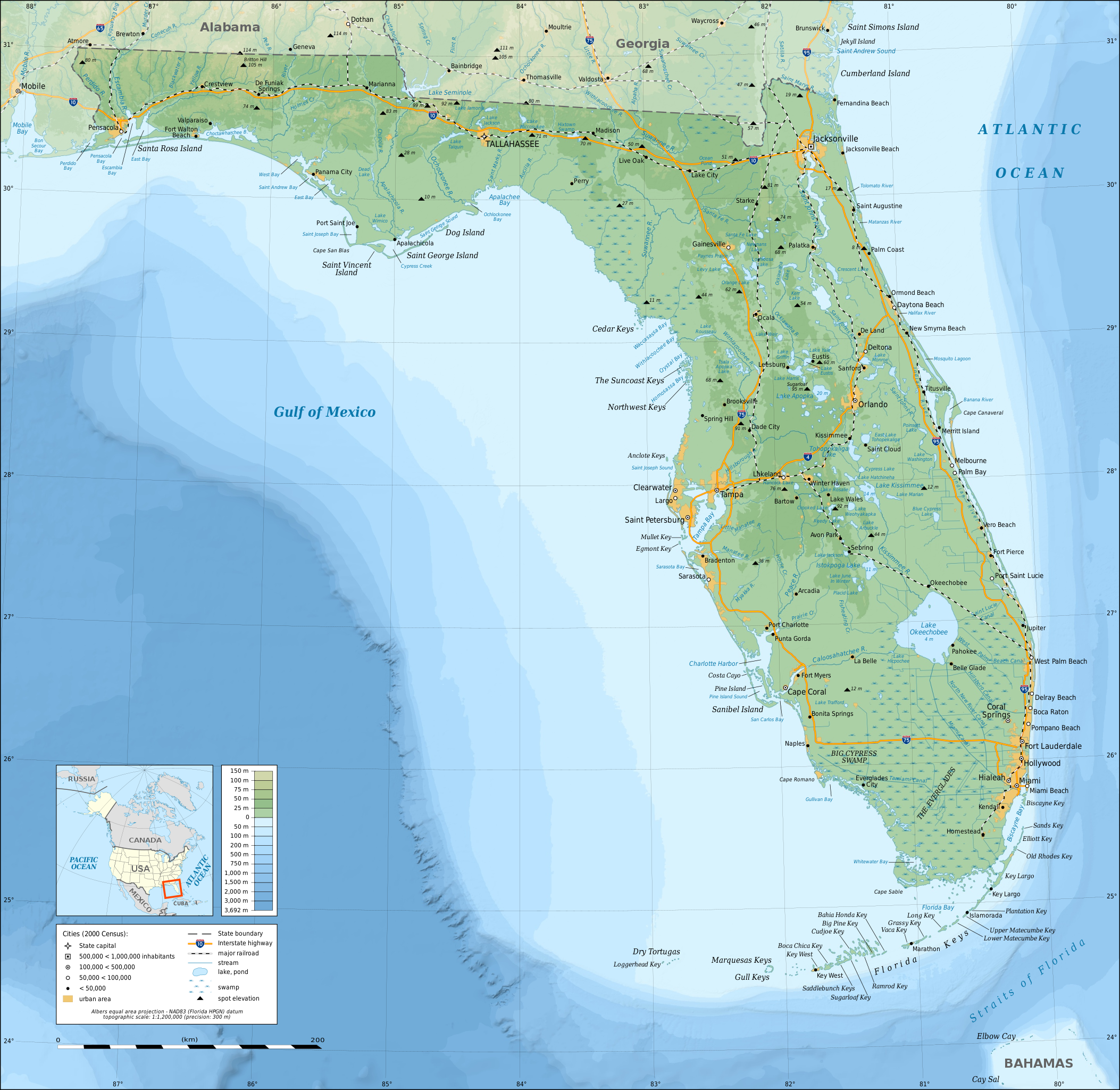
English: Topographic map of the State of Florida, USA (2000 Census).
Note: the background map is a raster image embedded in the SVG file. Español: Mapa topográfico del estado de Florida, Estados Unidos (censo del 2000).
Nota: el fondo del mapa es una imagen incrustada en el archivo SVG. Français : Carte topographique de l'état de Floride, États-Unis (recensement 2000). Note : le fond de carte est une image bitmap embarquée dans le fichier SVG. Albers equal area projection; NAD83 (Florida HPGN) datum |
||
| 日期 | |||
| 来源 |
自己的作品
|
||
| 創作作者 | |||
| 授权 (二次使用本文件) |
|
||
| 地理参考 | 如果不适当,请设置 warp_status = skip 为隐藏。 | ||
| 其他版本 |
[]
|


|
此SVG檔案包含可翻譯至您的語言的内嵌文字,可以使用任何可用SVG編輯器、文本編輯器或SVG翻譯工具來翻譯。詳情請見:關於翻譯SVG檔案。 |
许可协议
我,本作品著作权人,特此采用以下许可协议发表本作品:

|
已授权您依据自由软件基金会发行的无固定段落及封面封底文字(Invariant Sections, Front-Cover Texts, and Back-Cover Texts)的GNU自由文件许可协议1.2版或任意后续版本的条款,复制、传播和/或修改本文件。该协议的副本请见“GNU Free Documentation License”。 |
This file is licensed under the Creative Commons Attribution-Share Alike Attribution-Share Alike 4.0 International, 3.0 Unported, 2.5 Generic, 2.0 Generic and 1.0 Generic license.
- 您可以自由地:
- 共享 – 复制、发行并传播本作品
- 修改 – 改编作品
- 惟须遵守下列条件:
- 署名 – 您必须对作品进行署名,提供授权条款的链接,并说明是否对原始内容进行了更改。您可以用任何合理的方式来署名,但不得以任何方式表明许可人认可您或您的使用。
- 相同方式共享 – 如果您再混合、转换或者基于本作品进行创作,您必须以与原先许可协议相同或相兼容的许可协议分发您贡献的作品。
您可以选择您需要的许可协议。
文件历史
点击某个日期/时间查看对应时刻的文件。
| 日期/时间 | 缩略图 | 大小 | 用户 | 备注 | |
|---|---|---|---|---|---|
| 当前 | 2008年12月16日 (二) 15:26 | | 2,890 × 2,810(2.51 MB) | Sting | Added summits names |
| 2008年12月15日 (一) 01:34 |  | 2,890 × 2,810(2.51 MB) | Sting | == Summary == {{Information |Description={{en|Topographic map of the State of Florida, USA (2000 Census).<br/>''Note: the background map is a raster image embedded in the SVG file.''} |
文件用途
全域文件用途
以下其他wiki使用此文件:
- af.wikipedia.org上的用途
- ang.wikipedia.org上的用途
- arz.wikipedia.org上的用途
- az.wikipedia.org上的用途
- ban.wikipedia.org上的用途
- be.wikipedia.org上的用途
- bn.wikipedia.org上的用途
- ca.wikipedia.org上的用途
- de.wikipedia.org上的用途
- el.wikipedia.org上的用途
- en.wikipedia.org上的用途
- Portal:Geography
- Portal:Geography/Featured picture
- Portal:Florida
- User talk:Sting
- Wikipedia:Graphics Lab/Resources/Tutorials
- Wikipedia:Featured pictures/Diagrams, drawings, and maps/Maps
- Geography of Florida
- Florida
- Wikipedia:WikiProject United States/Recognized content
- Wikipedia:Featured pictures thumbs/26
- Wikipedia:WikiProject United States/Quality content
- User talk:Jujutacular/Archive 9
- Wikipedia:Featured picture candidates/December-2010
- Wikipedia:Featured picture candidates/Topographic map of Florida
- Talk:Geography of Florida
- Template:POTD/2013-03-03
- Portal:Geography/Featured picture/4
- Wikipedia:Picture of the day/March 2013
- User talk:Jujutacular/Archive 15
- Wikipedia:Main Page history/2013 March 3
- User:Abyssal/bla
- Portal:Geography/Selected picture
- Wikipedia:WikiProject United States/Featured pictures
- es.wikipedia.org上的用途
- fr.wikipedia.org上的用途
- fy.wikipedia.org上的用途
- ga.wikipedia.org上的用途
- gl.wikipedia.org上的用途
- gn.wikipedia.org上的用途
- hu.wikipedia.org上的用途
- hy.wikipedia.org上的用途
- hyw.wikipedia.org上的用途
- io.wikipedia.org上的用途
查看本文件的更多全域用途。