
File:MtRuapehu 23oct2002.jpg

本预览的尺寸:800 × 600像素。 其他分辨率:320 × 240像素 | 640 × 480像素 | 1,024 × 768像素 | 1,280 × 960像素 | 2,560 × 1,920像素 | 4,500 × 3,375像素。
原始文件 (4,500 × 3,375像素,文件大小:3.2 MB,MIME类型:image/jpeg)
摘要
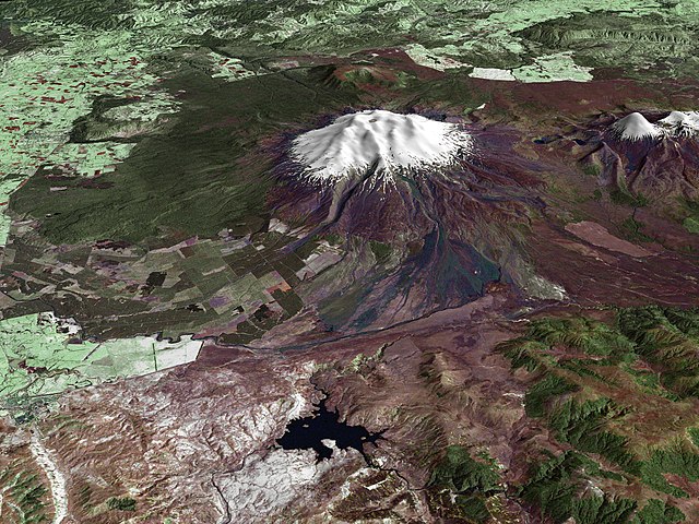
| 描述 | Composite image of Mount Ruapehu, with Hauhungatahi visible beyond. North Island, New Zealand. Image is composed of satellite imagery from Landsat and topography data from the Shuttle Radar Topography Mission aboard the Space Shuttle Endeavour. |
| 日期 | |
| 来源 | http://earthobservatory.nasa.gov/Newsroom/NewImages/images.php3?img_id=16522 |
| 作者 |
Landsat data provided courtesy of the University of Maryland Global Land Cover Facility Landsat processing by Laura Rocchio, Landsat Project Science Office SRTM 3-arcsecond elevation data courtesy of SRTM Team NASA/JPL/NIMA Visualization created by Earth Observatory staff. |
| 授权 (二次使用本文件) |
Public domain |
许可协议
| 本文件完全由NASA创作,在美国属于公有领域。根据NASA的版权方针,NASA的材料除非另有声明否则不受版权保护。(参见Template:PD-USGov/zh、NASA版权方针页面或JPL图片使用方针。) | ||
 |
警告:
|
文件历史
点击某个日期/时间查看对应时刻的文件。
| 日期/时间 | 缩略图 | 大小 | 用户 | 备注 | |
|---|---|---|---|---|---|
| 当前 | 2010年4月28日 (三) 15:17 | | 4,500 × 3,375(3.2 MB) | Originalwana | higher res |
| 2006年5月25日 (四) 20:56 |  | 1,800 × 1,800(819 KB) | Holly Cheng | {{Information | Description=Composite image of w:Mount Ruapehu, North Island, New Zealand. Image is composed of satellite imagery from Landsat and topography data from the Shuttle Radar Topography Mission aboard the Space Shuttle Endeavour. | Source=h |
文件用途
以下页面使用本文件:
全域文件用途
以下其他wiki使用此文件:
- ar.wikipedia.org上的用途
- ceb.wikipedia.org上的用途
- de.wikipedia.org上的用途
- en.wikipedia.org上的用途
- en.wikiversity.org上的用途
- gl.wikipedia.org上的用途
- hr.wikipedia.org上的用途
- hy.wikipedia.org上的用途
- it.wikipedia.org上的用途
- ja.wikipedia.org上的用途
- ko.wikipedia.org上的用途
- mk.wikipedia.org上的用途
- nl.wikipedia.org上的用途
- nn.wikipedia.org上的用途
- pl.wikipedia.org上的用途
- sh.wikipedia.org上的用途
- sl.wikipedia.org上的用途
- sv.wikipedia.org上的用途