
File:USGS magnitude 8 earthquakes since 1900.svg

此SVG文件的PNG预览的大小:512 × 512像素。 其他分辨率:240 × 240像素 | 480 × 480像素 | 768 × 768像素 | 1,024 × 1,024像素 | 2,048 × 2,048像素。
原始文件 (SVG文件,尺寸为512 × 512像素,文件大小:112 KB)
摘要
| 描述 |
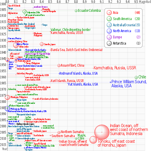
English: Earthquakes of moment magnitude 8.0 and greater from 1900 to 2018. The apparent 3D volumes of the bubbles are linearly proportional to their respective fatalities, i.e. their radii are linearly proportional to the cube root of the fatalities. Data is from https://earthquake.usgs.gov/earthquakes/eqarchives/year/mag8/magnitude8_1900_date.php ; The colour indicates the continent, and the legend counts the number of quakes for each. Notice the absence of Africa and the low presence of Antarctica and Europe. |
| 来源 | 自己的作品 |
| 作者 | Cmglee |
| SVG开发 | |
| 源代码 | PERL codetest
Perl script to create above; please do not remove.
#!/usr/bin/perl
$data_string = qq`
as|1902/06/11 05:|50.00|148.00|8.0||Sea of Okhotsk|-8
oc|1903/01/04 05:07|-20.00|-175.00|8.0||Tonga|8
eu|1903/08/11 04:32|36.36|22.97|8.3||southern Greece|-10
as|1905/07/09 09:40|49.0|99.0|8.4||Mongolia|-10
as|1905/07/23 02:46|49.0|98.0|8.4||central Mongolia|8
sa|1906/01/31 15:36|1.0|-81.5|8.8|1000|Colombia-Ecuador||Ecuador-Colombia
sa|1906/08/17 00:40|-33.0|-72.0|8.2|3882|Valparaiso, Chile|5|Valparaiso,Chile
as|1907/10/21 04:23|38.00|69.00|8.0||Afghanistan
sa|1908/12/12 12:08|-14.0|-78.0|8.2||off the coast of central Peru|5|off coast of central Peru
as|1911/06/15 14:26|28.0|130.0|8.1|12|Ryukyu Islands, Japan
as|1914/05/26 14:22|-2.|137.|8.0||West New Guinea|-10
as|1915/05/01 05:00|47.|155.|8.0||Kurile Islands|-4
oc|1917/05/01 18:26|-29.0|-177.0|8.0||Kermadec Islands, New Zealand|-8
oc|1917/06/26 05:49|-15.0|-173.0|8.4||Tonga
as|1918/08/15 12:18|5.653|123.563|8.0|50|Celebes Sea|-5
as|1918/09/07 17:16|45.5|151.5|8.2||Kuril Islands|-4
oc|1919/04/30 07:17|-19.823|-172.215|8.2||Tonga region|5
as|1920/06/05 04:21|23.5|122.0|8.0||Taiwan region|-5
oc|1920/09/20 14:39|-20.0|168.0|8.0||Loyalty Islands|10
sa|1922/11/11 04:32|-28.553|-70.755|8.5||Chile-Argentina Border|-12|Vallenar, Chile-Argentina border
as|1923/02/03 16:01|54.0|161.0|8.5||Kamchatka|10|Kamchatka, Russia, USSR
as|1924/04/14 16:20|7.023|125.954|8.3||Mindanao, Philippines||Mindanao,~Philippines
na|1928/06/17 03:19|16.33|-96.7|8.0||Oaxaca, Mexico
as|1931/08/10 21:18|47.1|89.8|8.0|5|northern Xinjiang, China|-8
na|1932/06/03 10:36|19.84|-103.99|8.1||Jalisco, Mexico|5
as|1933/03/02 17:31|39.22|144.62|8.4|2990|Sanriku, Japan
as|1934/01/15 08:43|27.55|87.09|8.1|10700|Bihar, India|10
as|1938/02/01 19:04|-5.05|131.62|8.5||Banda Sea||Banda Sea, Dutch East Indies (Indonesia)
na|1938/11/10 20:18|55.33|-158.37|8.2||Shumagin Islands, Alaska|-12
oc|1939/04/30 02:55|-10.5|158.5|8.0||Solomon Islands|-15
sa|1940/05/24 16:33|-10.5|-77.0|8.2||near the Coast of central Peru|-12|near coast of central Peru
eu|1941/11/25 18:03|37.171|-18.960|8.2||Azores-Cape St. Vincent Ridge|-10
sa|1942/08/24 22:50|-15.0|-76.0|8.2|30|Off the coast of central Peru|-3|off coast of central Peru
sa|1943/04/06 16:07|-30.75|-72.0|8.2|18|off the coast of Coquimbo, Chile|5|off coast of Coquimbo, Chile
as|1944/12/07 04:35|33.75|136.00|8.1|1223|Tonankai, Japan|-15|Japan
as|1945/11/27 21:57|24.5|63.0|8.0|4000|off the coast of Pakistan|-50|off coast of~Paki-~stan
na|1946/04/01 12:28|52.75|-163.50|8.1|165|Unimak Islands, Alaska|-10|Unimak Islands, Alaska, USA
na|1946/08/04 17:51|19.25|-69.00|8.0|100|Dominican Republic|10|Domi-~nican~Repu-~blic
as|1946/12/20 19:19|32.5|134.5|8.1|1330|Nankaido, Japan|-2
as|1948/01/24 17:46|10.5|122.0|8.2|72|Panay, Philippines|5
na|1949/08/22 04:01|53.62|-133.27|8.1||Queen Charlotte Island, B.C., Canada|10|Queen Charlotte Island, Canada
as|1950/08/15 14:09|28.5|96.5|8.6|1526|Assam-Tibet||Assam-Tibet, China
as|1952/03/04 01:22|42.5|143.0|8.1|31|Hokkaido, Japan region|10
as|1952/11/04 16:58|52.76|160.06|9.0||Kamchatka, Russia||Kamchatka, Russia, USSR
na|1957/03/09 14:22|51.56|-175.39|8.6||Andreanof Islands, Alaska||Andreanof Islands, Alaska, USA
as|1957/12/04 03:37|45.15|99.21|8.1||Gobi-Altai, Mongolia|-10
as|1958/11/06 22:58|44.329|148.623|8.3||Kuril Islands|-3|Kuril Islands, USSR
as|1959/05/04 07:15|53.351|159.645|8.2|1|near the east coast of Kamchatka|8|near east coast of~Kamchatka, USSR
sa|1960/05/22 19:11|-38.29|-73.05|9.5|1655|Chile
as|1963/10/13 05:17|44.9|149.6|8.5||Kuril Islands|-5|Kuril Islands, Russia, USSR
na|1964/03/28 03:36|61.02|-147.65|9.2|125|Prince William Sound, Alaska||Prince William Sound,~Alaska, USA
na|1965/02/04 05:01|51.21|-178.50|8.7|5|Rat Islands, Alaska|10|Rat Islands, Alaska, USA
sa|1966/10/17 21:41|-10.807|-78.684|8.1|125|near the coast of central Peru|-5|near coast of central Peru
as|1968/05/16 00:49|40.903|143.346|8.2|47|off the east coast of Honshu, Japan|-4|off east coast of Honshu, Japan
as|1969/08/11 21:27|43.478|147.815|8.2||Kuril Islands|2|Kuril Islands, Russia, USSR
sa|1970/07/31 17:08|-1.49|-72.56|8.0||Colombia|-8
as|1971/01/10 07:17|-3.132|139.697|8.1||Papua, Indonesia|5
sa|1974/10/03 14:21|-12.254|-77.524|8.1|78|near the coast of central Peru|-7|near coast of central Peru
as|1976/08/16 16:11|6.292|124.090|8.0|8000|Mindanao, Philippines|-5
oc|1977/06/22 12:08|-22.878|-175.900|8.1||Tonga region|8
as|1977/08/19 06:08|-11.085|118.464|8.3|100|south of Sumbawa, Indonesia
sa|1979/12/12 07:59|1.598|-79.358|8.1|600|near the coast of Ecuador|10|near coast of Ecuador
sa|1985/03/03 22:47|-33.135|-71.871|8.0|177|offshore Valparaiso, Chile|-20
na|1985/09/19 13:17|18.190|-102.533|8.0|9500|Michoacan, Mexico
na|1986/05/07 22:47|51.520|-174.776|8.0||Andreanof Islands, Aleutian Islands, Alaska|15|Andreanof Islands, Aleutian Islands, Alaska, USA
oc|1989/05/23 10:54|-52.341|160.568|8.1||Macquarie Island region|10
sa|1994/06/09 00:33|-13.841|-67.553|8.2|5|La Paz, Bolivia|-20|La Paz,~Bolivia
as|1994/10/04 13:22|43.773|147.321|8.3|11|Kuril Islands|-5|Kuril Islands, Russia
sa|1995/07/30 05:11|-23.340|-70.294|8.0|3|Near Coast of Northern Chile|-32|near coast of~north Chile
na|1995/10/09 15:35|19.055|-104.205|8.0|49|Near Coast of Jalisco, Mexico|2|near coast of~Mexico
as|1996/02/17 05:59|-0.891|136.952|8.2|166|Irian Jaya region, Indonesia
an|1998/03/25 03:12|-62.877|149.527|8.1||Balleny Islands region|-2
oc|2000/11/16 04:54|-3.980|152.169|8.0|2|New Ireland region, Papua New Guinea|-8
sa|2001/06/23 20:33|-16.264|-73.641|8.4|75|near the coast of southern Peru|-20|near coast of~southern Peru
as|2003/09/25 19:50|41.815|143.910|8.3||Hokkaido, Japan region||Hokkaido, Japan
oc|2004/12/23 14:59|-49.312|161.345|8.1||north of Macquarie Island|-28|north of Macquarie~Island, Australia
as|2004/12/26 00:58|3.295|95.982|9.1|227898|off the west coast of northern Sumatra|-50|Indian Ocean, off~west coast of northern~Sumatra, Indonesia
as|2005/03/28 16:09|2.074|97.013|8.6|1313|Northern Sumatra, Indonesia|-5|Northern Sumatra
oc|2006/05/03 15:26|-20.187|-174.123|8.0||Tonga|-5
as|2006/11/15 11:14|46.592|153.226|8.3||Kuril Islands|5
as|2007/01/13 04:23:21|46.243|154.524|8.1||East of the Kuril Islands|-13|east of Kuril Islands
oc|2007/04/01 20:39:58|-8.466|157.043|8.1|34|Solomon Islands|5
sa|2007/08/15 23:40:57|-13.386|-76.603|8.0|650|Near the Coast of Central Peru||near~coast~of Peru
as|2007/09/12 11:10:26|-4.438|101.367|8.5|25|Southern Sumatra, Indonesia|5|Southern Sumatra
oc|2009/09/29 17:48:10|-15.489|-172.095|8.1|192|Samoa Islands region|0
sa|2010/02/27 06:34:14|-35.846|-72.719|8.8|577|Offshore Maule, Chile|-25|Maule,~Chile
as|2011/03/11 05:46:23|38.322|142.369|9.0|28050|Near the East Coast of Honshu, Japan|15|Tōhoku, off east coast~of Honshu, Japan
as|2012/04/11 08:38:37|2.311|93.063|8.6||off the west coast of northern Sumatra|5|Indian Ocean, off west~coast of north Sumatra
as|2012/04/11 10:43:09|0.773|92.452|8.2||off the west coast of northern Sumatra|-7|Indian Ocean, off Sumatra coast
oc|2013/02/06 01:12:27|-10.738|165.138|8.0|13|Lata,~Solomon Islands|7|
as|2013/05/24 06:44:49|54.874|153.281|8.3||Sea of Okhotsk|7|
sa|2014/04/01 23:46:47|-19.642|-70.817|8.2|6|offshore~N.Chile|-7|
sa|2015/09/16 22:54|-31.570|-71.654|8.3|14|offshore Coquimbo, Chile
na|2017/09/08 04:49|15.022|-93.899|8.2|98|offshore Chiapas, Mexico|-3
oc|2018/08/19 00:19|-18.178|-178.111|8.2|0|Fiji region|4
`;
%continents = (
"na" => { "colour" => "#0000ff", "count" => 0, "name" => "North America" },
"sa" => { "colour" => "#009900", "count" => 0, "name" => "South America" },
"eu" => { "colour" => "#9900cc", "count" => 0, "name" => "Europe" },
"af" => { "colour" => "#996600", "count" => 0, "name" => "Africa" },
"as" => { "colour" => "#ff0000", "count" => 0, "name" => "Asia" },
"oc" => { "colour" => "#006699", "count" => 0, "name" => "Australia/Oceania" },
"an" => { "colour" => "#000000", "count" => 0, "name" => "Antarctica" },
undef);
@continent_order = ("as", "sa", "oc", "na", "eu", "an", "af");
# @continent_order = ("na","sa", "eu", "af", "as", "oc", "an");
$mag_min = 8; $mag_max = 9.6; $date_min = 1900; $date_max = 2020;
$x_min = 0; $x_max = &x($mag_max); $y_min = 0; $y_max = &y($date_max);
$x_legend = 790; $y_legend = 40; $w_legend = 310; $h_legend = 320;
$x_viewbox = -60; $y_viewbox = -28; $width_viewbox = 1230; $height_viewbox = 1230;
$out_graph = $out_legend = $out_grid = $out_grad = "";
$x_margin = &x($mag_min);
sub year_fraction {
($y, $m, $d) = split(/\//, $_[0]);
# $y = $_[0];
# $m = $_[1] || 1;
# $d = $_[2] || 1;
$is_leap_year = $y % 100 ? ($y % 4 == 0) : ($y % 400 == 0);
$day_of_year = int($d - ($m < 3 ? 30 : $is_leap_year ? 31 : 32) + 30.56 * $m);
return $y + ($day_of_year - 1) / ($is_leap_year ? 366 : 365);
}
sub x { return sprintf("%.3f", 700 * ($_[0] - $mag_min)); }
sub y { return sprintf("%d", 10 * ($_[0] - $date_min)); }
$double_dash = "-" . "-";
$file_out = $0; $file_out =~ s/[^\.]*$/svg/;
@data = split(/\n/, $data_string);
foreach (@data) {
if ($_ && substr($_, 0, 1) ne "#") {
($continent, $datetime, $latitude, $longitude, $magnitude, $fatalities, $region, $label_offset, $label) = split(/\|/, $_);
if ($magnitude >= $mag_min) {
print "$continent\t$datetime\t$latitude\t$longitude\t$magnitude\t$fatalities\t$region\t$label_offset\t$label\n";
($date, $time) = split(/\s/, $datetime);
$x = &x($magnitude);
$y = &y(&year_fraction($date));
$r = $fatalities ** (1 / 3);
$x_label = $x + $r + 4;
$y_label = $y + $label_offset + 8;
$colour = $continents{$continent}{"colour"};
++$continents{$continent}{"count"};
if ($label eq "") { $label = $region; }
if ($label =~ m/~/) {
$label =~ s`~`</tspan><tspan x="0" dy="0.9em">`g;
$label = qq`<tspan>${label}</tspan>`;
}
$font_size = $magnitude < 8.5 ? qq` font-size="20"` :
($magnitude >= 9 ? qq` font-size="36"` : qq``);
$out_graph .= qq`
<g stroke="${colour}" fill="${colour}">
<text transform="translate(${x_label},${y_label}) scale(0.8,1)" x="0" y="0"${font_size} stroke="none">${label}</text>
<circle cx="${x}" cy="${y}" r="${r}" fill="url(#grad_${continent})"/>
<circle cx="${x}" cy="${y}" r="2" fill-opacity="0.5"/>
<path d="M ${x} ${y} H ${x_margin}" stroke-width="0.5" stroke-opacity="0.5"/>
</g>`;
}
}
}
$y = 35;
foreach (@continent_order) {
$count = $continents{$_}{"count"};
if ($count > 0) {
$colour = $continents{$_}{"colour"};
$name = $continents{$_}{"name"};
$out_grad .= qq`
<radialGradient id="grad_${_}" cx="50%" cy="50%" r="50%" fx="25%" fy="25%">
<stop offset="50%" stop-color="${colour}" stop-opacity="0"/>
<stop offset="100%" stop-color="${colour}" stop-opacity="0.5"/>
</radialGradient>`;
$out_legend .= qq`
<text transform="translate(70,${y}) scale(0.8,1)" x="0" y="10" fill="${colour}"><tspan>${name}</tspan><tspan x="280" text-anchor="end">(${count})</tspan></text>
<circle cx="40" cy="${y}" r="20" stroke="${colour}" fill="url(#grad_${_})"/>
<circle cx="40" cy="${y}" r="2" stroke="${colour}"/>`;
$y += 50;
}
}
for ($mag = $mag_max; $mag >= $mag_min; $mag -= 0.1) {
$x = &x($mag);
$mag = sprintf("%0.1f", $mag);
$out_grid .= qq`
<use xlink:href="#grid_x" transform="translate(${x},0)"/>`;
if ($mag < $mag_max) {
$out_grid .= qq`
<text transform="translate(${x},-5) scale(0.8,1)" x="0" y="0" text-anchor="middle">${mag}</text>`;
}
}
for ($date = $date_max; $date >= $date_min; $date -= 5) {
$y = &y($date);
if ($date > $date_min) {
$out_grid .= qq`
<use xlink:href="#grid_y_5" transform="translate(0,${y})"/>`;
if ($date < $date_max) {
$out_grid .= qq`
<text transform="translate(-5,${y}) scale(0.8,1)" x="0" y="10" text-anchor="end">${date}</text>`;
}
} else {
$out_grid .= qq`
<text transform="translate(-5,${y}) scale(0.8,1)" x="0" y="15" text-anchor="end">${date}</text>`;
}
}
open (FILE_OUT, ">$file_out");
print FILE_OUT qq`<?xml version="1.0" encoding="utf-8"?>
<svg xmlns="http://www.w3.org/2000/svg" xmlns:xlink="http://www.w3.org/1999/xlink" width="100%" height="100%" viewBox="${x_viewbox} ${y_viewbox} ${width_viewbox} ${height_viewbox}">
<title>Magnitude 8.0 and greater earthquakes since 1900</title>
<desc>Earthquakes of moment magnitude 8.0 and greater since 1900, charted by CMG Lee. The apparent 3D volumes of the bubbles are linearly proportional to their respective fatalities, i.e. their radii are linearly proportional to the cube root of the fatalities. Data is from https://earthquake.usgs.gov/earthquakes/eqarchives/year/mag8/magnitude8_1900_date.php , http://comcat.cr.usgs.gov/earthquakes/eventpage/usc000f1s0 and http://comcat.cr.usgs.gov/earthquakes/eventpage/usb000h4jh .</desc>
<defs>${out_grad}
<path id="grid_x" d="M 0 ${y_min} V ${y_max}"/>
<path id="grid_y" d="M ${x_min} 0 h -1 H ${x_max}"/>
<path id="grid_y_tick" d="M ${x_min} 0 h -2 H ${x_max}" stroke-width="2"/>
<g id="grid_y_5">
<use xlink:href="#grid_y_tick"/>
<use xlink:href="#grid_y" transform="translate(0,-10)"/>
<use xlink:href="#grid_y" transform="translate(0,-20)"/>
<use xlink:href="#grid_y" transform="translate(0,-30)"/>
<use xlink:href="#grid_y" transform="translate(0,-40)"/>
</g>
</defs>
<rect x="${x_viewbox}" y="${y_viewbox}" width="${width_viewbox}" height="${height_viewbox}" fill="#ffffff"/>
<g font-family="sans-serif" letter-spacing="-2" font-size="28" text-anchor="start">
<g stroke="#cccccc" fill="#000000">${out_grid}
<path d="M 0 ${y_max} V 0 H ${x_max}" stroke="#000000" fill="none"/>
</g>
<g transform="scale(0.8,1)" fill="#666666">
<text x="-55" y="1195">Year</text>
<text x="1340" y="-5">Magnitude</text>
</g>
<g transform="translate(${x_legend},${y_legend})">
<rect x="0" y="0" width="${w_legend}" height="${h_legend}" rx="20" ry="20" stroke="#000000" fill="#ffffff"/>${out_legend}
</g>
${out_graph}
</g>
</svg>
<!${double_dash} Perl script to create above; please do not remove.
`;
open (FILE_IN, $0);
while (<FILE_IN>) { print FILE_OUT $_; }
close FILE_IN;
print FILE_OUT "# ${double_dash}>";
close FILE_OUT;
#
|
许可协议
我,本作品著作权人,特此采用以下许可协议发表本作品:
本文件采用知识共享署名-相同方式共享 3.0 未本地化版本许可协议授权。
- 您可以自由地:
- 共享 – 复制、发行并传播本作品
- 修改 – 改编作品
- 惟须遵守下列条件:
- 署名 – 您必须对作品进行署名,提供授权条款的链接,并说明是否对原始内容进行了更改。您可以用任何合理的方式来署名,但不得以任何方式表明许可人认可您或您的使用。
- 相同方式共享 – 如果您再混合、转换或者基于本作品进行创作,您必须以与原先许可协议相同或相兼容的许可协议分发您贡献的作品。

|
已授权您依据自由软件基金会发行的无固定段落及封面封底文字(Invariant Sections, Front-Cover Texts, and Back-Cover Texts)的GNU自由文件许可协议1.2版或任意后续版本的条款,复制、传播和/或修改本文件。该协议的副本请见“GNU Free Documentation License”。 |
您可以选择您需要的许可协议。
文件历史
点击某个日期/时间查看对应时刻的文件。
| 日期/时间 | 缩略图 | 大小 | 用户 | 备注 | |
|---|---|---|---|---|---|
| 当前 | 2018年10月7日 (日) 07:53 | | 512 × 512(112 KB) | JoKalliauer | Inkscape: --verb=SelectionUnGroup (inkscape --verb=EditSelectAll --verb=SelectionUnGroup --verb=SelectionUnGroup --verb=SelectionUnGroup --verb=SelectionUnGroup --verb=SelectionUnGroup --verb=FileSave --verb=FileClose ./${file}u.svg --verb=FileQuit) |
| 2018年10月6日 (六) 22:04 |  | 512 × 512(40 KB) | JoKalliauer | try to simplify file | |
| 2018年10月5日 (五) 18:47 |  | 512 × 512(61 KB) | Cmglee | Try to fix bubbles. | |
| 2018年10月4日 (四) 18:18 |  | 512 × 512(61 KB) | Cmglee | Update up to 2018-10-04. | |
| 2015年4月2日 (四) 23:21 |  | 512 × 512(60 KB) | Cmglee | Add 2014 quake, axis labels (w:user_talk:cmglee#Earthquake_graph) and minor cosmetic changes. | |
| 2013年7月3日 (三) 12:13 |  | 512 × 512(60 KB) | Cmglee | Add 2013 quakes and minor cosmetic changes. | |
| 2012年4月13日 (五) 22:48 |  | 512 × 512(59 KB) | Cmglee | Add counts to legend and refine more labels. | |
| 2012年4月13日 (五) 22:09 |  | 512 × 512(59 KB) | Cmglee | Refine labels. | |
| 2012年4月13日 (五) 21:16 |  | 512 × 512(58 KB) | Cmglee | Add magnitude 8.0 to 8.4 earthquakes to match filename. | |
| 2012年4月13日 (五) 19:24 |  | 512 × 512(23 KB) | Cmglee | Shorten label to fit. |
文件用途
全域文件用途
以下其他wiki使用此文件:
- am.wikipedia.org上的用途
- ar.wikipedia.org上的用途
- en.wikipedia.org上的用途
- fa.wikipedia.org上的用途
- gl.wikipedia.org上的用途
- hu.wikipedia.org上的用途
- id.wikipedia.org上的用途
- ko.wikipedia.org上的用途
- mnw.wikipedia.org上的用途
- ms.wikipedia.org上的用途
- pa.wikipedia.org上的用途
- pt.wikipedia.org上的用途
- tr.wikipedia.org上的用途
- uk.wikipedia.org上的用途