
File:Audencias of Viceroyalty of Peru.PNG
本预览的尺寸:458 × 600像素。 其他分辨率:183 × 240像素 | 366 × 480像素 | 766 × 1,003像素。
原始文件 (766 × 1,003像素,文件大小:168 KB,MIME类型:image/png)

|
此map图片可使用矢量图形重新创建为SVG文件。这具有很多好处;更多信息请参见共享资源:待清理媒体。如果存在此图片的SVG格式,请将其上传,然后将此模板替换为
{{vector version available|新图片名称}}。
建议您将SVG命名为“Audencias of Viceroyalty of Peru.svg”,这样在使用Vector version available(或Vva)模板时就不需要填写新图片名称参数。 |
摘要
| 描述 |
Čeština: Až do 18. století byla španělská část Jižní Ameriky soustředěna do jednoho místokrálovství Peru.
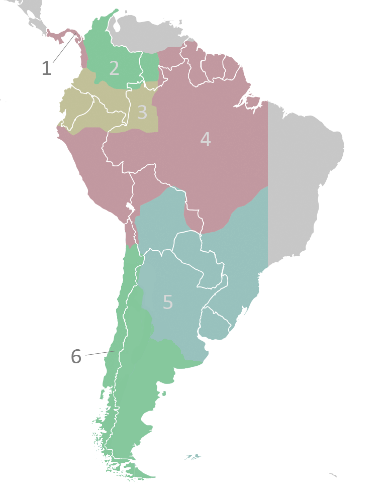
English: The audiencias of the Viceroyalty of Peru c.1650. Territorial divisions of the Viceroyalty of Peru as described by the laws compiled in the Recopilación of 1680.
Italiano: Le audiencias del Vicereame del Perù (1650 circa). Quella di Charcas è nella sezione 2[1].
Lietuvių: Vicekaralystės audiencijos.
1. Panamá2. Santa Fé de Bogotá 3. Quito 4. Lima 5. La Plata de Los Charcas 6. Chile |
| 日期 | 2008年4月18日 (原始上传日期) |
| 来源 | Transferred from en.wikipedia to Commons by Jalo using CommonsHelper. |
| 作者 | 英语维基百科的Vivaperucarajo |
许可协议
英语维基百科的Vivaperucarajo,本作品著作权人,特此采用以下许可协议发表本作品:
本文件采用知识共享署名-相同方式共享 2.5 通用许可协议授权。
署名: 英语维基百科的Vivaperucarajo
- 您可以自由地:
- 共享 – 复制、发行并传播本作品
- 修改 – 改编作品
- 惟须遵守下列条件:
- 署名 – 您必须对作品进行署名,提供授权条款的链接,并说明是否对原始内容进行了更改。您可以用任何合理的方式来署名,但不得以任何方式表明许可人认可您或您的使用。
- 相同方式共享 – 如果您再混合、转换或者基于本作品进行创作,您必须以与原先许可协议相同或相兼容的许可协议分发您贡献的作品。
原始上传日志
The original description page was here. All following user names refer to en.wikipedia.
- 2008-04-18 01:56 Vivaperucarajo 331×446× (19530 bytes) {{self|cc-by-sa-2.5}} [[Category:Locator maps of former territories|Peru, Viceroyalty of]] [[Category:Maps of subdivisions of the Viceroyalty of Peru]]
文件历史
点击某个日期/时间查看对应时刻的文件。
| 日期/时间 | 缩略图 | 大小 | 用户 | 备注 | |
|---|---|---|---|---|---|
| 当前 | 2022年11月22日 (二) 17:27 | | 766 × 1,003(168 KB) | Janitoalevic | Reverted to version as of 03:41, 23 August 2022 (UTC) |
| 2022年9月1日 (四) 00:30 |  | 766 × 1,003(168 KB) | Floppa Historico | Reverted to version as of 22:21, 7 July 2022 (UTC) | |
| 2022年8月23日 (二) 03:41 |  | 766 × 1,003(168 KB) | Janitoalevic | . | |
| 2022年7月7日 (四) 22:21 |  | 766 × 1,003(168 KB) | Janitoalevic | Límite entre Chile y Perú en el río Loa | |
| 2018年4月30日 (一) 23:57 |  | 766 × 1,003(128 KB) | Janitoalevic | Fixed borders | |
| 2010年2月22日 (一) 02:53 |  | 766 × 1,003(167 KB) | AniRaptor2001 | Added lines between 1, 6 and countries | |
| 2010年2月22日 (一) 02:50 |  | 766 × 1,003(166 KB) | AniRaptor2001 | New base file, new colors | |
| 2009年4月27日 (一) 13:53 |  | 331 × 446(19 KB) | File Upload Bot (Magnus Manske) | {{BotMoveToCommons|en.wikipedia|year={{subst:CURRENTYEAR}}|month={{subst:CURRENTMONTHNAME}}|day={{subst:CURRENTDAY}}}} {{Information |Description={{en|''no original description''}} |Source=Transferred from [http://en.wikipedia.org en.wikipedia]; transfer |
文件用途
以下2个页面使用本文件:
全域文件用途
以下其他wiki使用此文件:
- ast.wikipedia.org上的用途
- ca.wikipedia.org上的用途
- cs.wikipedia.org上的用途
- de.wikipedia.org上的用途
- en.wikipedia.org上的用途
- es.wikipedia.org上的用途
- Historia de la Argentina
- Virreinato del Perú
- Anexo:Gobernantes de Argentina
- Real Audiencia de Santafé de Bogotá
- Real Audiencia de Panamá
- Organización territorial del virreinato del Perú
- Conflicto limítrofe entre Bolivia y Perú
- Cabildo de Buenos Aires (institución)
- Estados andinos
- Juan José Romualdo Rocha
- fi.wikipedia.org上的用途
- it.wikipedia.org上的用途
- lez.wikipedia.org上的用途
- lt.wikipedia.org上的用途
- pl.wikipedia.org上的用途
- ro.wikipedia.org上的用途
- sh.wikipedia.org上的用途
- sk.wikipedia.org上的用途
- sr.wikipedia.org上的用途
- sv.wikipedia.org上的用途
- uk.wikipedia.org上的用途
- vi.wikipedia.org上的用途