
File:Administrative Divisions of Zimbabwe.svg

此 SVG 檔案的 PNG 預覽的大小:630 × 490 像素。 其他解析度:309 × 240 像素 | 617 × 480 像素 | 988 × 768 像素 | 1,280 × 996 像素 | 2,560 × 1,991 像素。
原始檔案 (SVG 檔案,表面大小:630 × 490 像素,檔案大小:308 KB)
摘要
| 描述 |
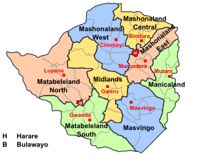
English: A map showing the administrative divisions of Zimbabwe |
| 日期 | |
| 來源 | 自己的作品 |
| 作者 | Mangwanani |
| 授權許可 (重用此檔案) |
Own Work - free to use |
授權條款
| 我,此作品的版權所有人,釋出此作品至公共領域。此授權條款在全世界均適用。 這可能在某些國家不合法,如果是的話: 我授予任何人有權利使用此作品於任何用途,除受法律約束外,不受任何限制。 |
檔案歷史
點選日期/時間以檢視該時間的檔案版本。
| 日期/時間 | 縮圖 | 尺寸 | 使用者 | 備註 | |
|---|---|---|---|---|---|
| 目前 | 2018年8月29日 (三) 14:53 | | 630 × 490(308 KB) | Gajmar | Changed borders from constituencies to actual districts |
| 2011年10月27日 (四) 15:34 |  | 630 × 490(386 KB) | Hel-hama | Slight improvements to make the map more readable. | |
| 2008年12月11日 (四) 17:20 |  | 630 × 490(250 KB) | Mangwanani | added lupane | |
| 2008年12月11日 (四) 17:11 |  | 630 × 490(249 KB) | Mangwanani | == Summary == {{Information |Description={{en|1=A map showing the administrative divisions of Zimbabwe}} |Source=Own work by uploader |Author=Mangwanani |Date=2008/12/08 |Permission=Own Work - free to use |other_versions= }} <!--{{Ima |
檔案用途
下列頁面有用到此檔案:
全域檔案使用狀況
以下其他 wiki 使用了這個檔案:
- ast.wikipedia.org 的使用狀況
- ca.wikipedia.org 的使用狀況
- de.wikipedia.org 的使用狀況
- en.wikipedia.org 的使用狀況
- eu.wikipedia.org 的使用狀況
- fa.wikipedia.org 的使用狀況
- fi.wikipedia.org 的使用狀況
- id.wikipedia.org 的使用狀況
- is.wikipedia.org 的使用狀況
- it.wikipedia.org 的使用狀況
- ja.wikipedia.org 的使用狀況
- ko.wikipedia.org 的使用狀況
- li.wikipedia.org 的使用狀況
- lv.wikipedia.org 的使用狀況
- ms.wikipedia.org 的使用狀況
- mzn.wikipedia.org 的使用狀況
- nl.wikipedia.org 的使用狀況
- simple.wikipedia.org 的使用狀況
- si.wikipedia.org 的使用狀況
- sn.wikipedia.org 的使用狀況
- th.wikipedia.org 的使用狀況
- tum.wikipedia.org 的使用狀況
- vi.wikipedia.org 的使用狀況
- www.wikidata.org 的使用狀況
- zu.wikipedia.org 的使用狀況