
File:Cosne, environs au sud - Bannay, Saint-Père, Villechaud.png

預覽大小:800 × 427 像素。 其他解析度:320 × 171 像素 | 640 × 342 像素 | 1,075 × 574 像素。
原始檔案 (1,075 × 574 像素,檔案大小:1.55 MB,MIME 類型:image/png)
摘要
| 描述 |
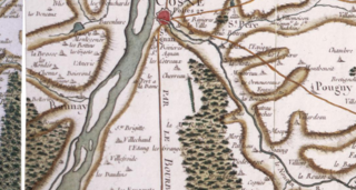
English: 18th century Cassini map of France, detail of the surroundings south of Cosne, in the north-west of the present Nièvre departement, in Burgundy. The town of Cosne is centered on the upper edge of the picture, standing on the right bank of the Loire river that crosses the picture in roughly south-west/-north-east direction. The "road (from Paris) to Lyon through the Bourbonnais" also crosses the picture, coming due south from Cosne. The river reaching Cosne and the Loire from the south-east is the Nohain. After Cosne, the main town is Bannay, showing here on the left bank of the Loire (therefore in the present Cher département). Many small villages and hamlets are indicated on the map. Villechaud (fr) is 4.5 km south of Cosne, about 1 mi west of the road to Lyon and 1/2 mi east of the Loire river. 1/3 of a mile south-west of it is Villefroide, another hamlet.
Français : Carte de Cassini (XVIIIe s.), détail des environs au sud de Cosne, dans le nord-est du département de la Nièvre, en Bourgogne. Cosne est au centre du bord supérieur de la carte, au bord et rive droite de la Loire qui traverse l'image dans une direction approximative S-O/N-E. La rivière qui rejoint Cosne et la Loire par le sud-est est le Nohain.
Après Cosne, une autre grande ville est Bannay, sur la rive gauche de la Loire (donc dans le présent département du Cher). La "route de (Paris à) Lyon par le Bourbonnais" traverse aussi la carte, se dirigeant plein sud depuis Cosne. La carte indique de nombreux villages. Villechaud est à 4,5 km au sud de Cosne à environ 1,6 km à l'ouest de la route de Lyon, et à environ 800 m à l'est de la Loire. Environ 90 m au sud-ouest de Villechaud est le hameau de Villefroide. |
| 日期 | |
| 來源 | geoportail.gouv.fr |
| 作者 | Cassini family (18th century) |
| 拍攝地點 | | 位於此地的本圖片與其他圖片: OpenStreetMap |
|---|
The coordinates are given for a point roughly at the center of the map detail shown.
授權條款
|
本作品在其來源國以及其他著作權期限是作者逝世後70年或以下的國家與地區屬於公有領域。 | |
| 此作品無已知的著作權限制,亦不受所有相關和鄰接的權利限制。 | |
檔案歷史
點選日期/時間以檢視該時間的檔案版本。
| 日期/時間 | 縮圖 | 尺寸 | 使用者 | 備註 | |
|---|---|---|---|---|---|
| 目前 | 2017年4月24日 (一) 12:45 | | 1,075 × 574(1.55 MB) | Pueblo89 | User created page with UploadWizard |
檔案用途
下列頁面有用到此檔案:
全域檔案使用狀況
以下其他 wiki 使用了這個檔案:
- fr.wikipedia.org 的使用狀況