
File:Farewell Spit.jpg

原始檔案 (3,888 × 2,502 像素,檔案大小:1.22 MB,MIME 類型:image/jpeg)
摘要
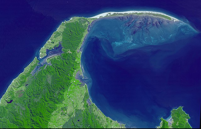
| 描述 | A cloud-free view of Farewell Spit, on the northern tip of New Zealand’s South Island. |
| 日期 | |
| 來源 | NASA's Earth Observatory |
| 作者 | NASA/GSFC/METI/ERSDAC/JAROS, and U.S./Japan ASTER Science Team |
| 授權許可 (重用此檔案) |
Public domain - original work of NASA |
This image provides a cloud-free view of Farewell Spit. On the northern tip of New Zealand’s South Island, Farewell Spit stretches 30 kilometers eastward into the Tasman Sea from the Cape Farewell mainland. A sandy beach faces the open waters of the Tasman Sea, while an intricate wetland ecosystem faces south toward Golden Bay. On the southern side, the spit is protected by several kilometers of mudflats, which are alternately exposed and inundated with the tidal rhythms of the ocean. The wetlands of Farewell Spit are on the Ramsar List of Wetlands of International Significance.
This image from the Advanced Spaceborne Thermal Emission and Reflection Radiometer (ASTER) on NASA’s Terra satellite shows Cape Farewell (left) and Farewell Spit. The sandy dunes on the north side of the spit give way to green vegetation along the southern perimeters. The image captured a great amount of detail of the submerged tidal flats, which appear in shades of bluish-purple. The flats are etched with many channels, giving the flats the appearance of underwater mountains and canyons. Near the shore, the blue-purple color of the flats is tinged with green (see high-resolution image), suggesting the area is home to aquatic plants that can tolerate daily flooding.
More than 80 species of wetland birds have been observed at Farewell Spit. Among them are numerous species of migratory shorebirds traveling the East Asia-Australasia flyway. Some birds arrive for the summer, while others fly in for the winter. According to the New Zealand Department of Conservation, the tidal mudflats on Farewell Spit are also an important molting (feather shedding and replacement) site for 12,000 black swans.
This image was acquired February 13, 2001. The area shown is located near 40.7 degrees south latitude, 172.6 degrees east longitude. The large image covers an area of 37.5 x 58.3 km.
NASA/GSFC/METI/ERSDAC/JAROS, and U.S./Japan ASTER Science Team http://earthobservatory.nasa.gov/Newsroom/NewImages/images.php3?img_id=17000
”The purpose of NASA's Earth Observatory is to provide a freely-accessible publication on the Internet where the public can obtain new satellite imagery and scientific information about our home planet. The focus is on Earth's climate and environmental change. In particular, we hope our site is useful to public media and educators. Any and all materials published on the Earth Observatory are freely available for re-publication or re-use, except where copyright is indicated. We ask that NASA's Earth Observatory be given credit for its original materials.”
授權條款
| 本作品由NASA創作,屬於公有領域。根據NASA的版權政策:“NASA的創作除非另有聲明否則不受版權保護。”(參見:Template:PD-USGov/zh,NASA版權政策或JPL圖像使用政策) | ||
 |
警告:
|
檔案歷史
點選日期/時間以檢視該時間的檔案版本。
| 日期/時間 | 縮圖 | 尺寸 | 使用者 | 備註 | |
|---|---|---|---|---|---|
| 目前 | 2006年5月19日 (五) 16:43 | | 3,888 × 2,502(1.22 MB) | Avenue | == Summary == {{Information| |Description=A cloud-free view of Farewell Spit, on the northern tip of New Zealand’s South Island. |Source=[http://earthobservatory.nasa.gov/Newsroom/NewImages/images |
檔案用途
下列頁面有用到此檔案:
全域檔案使用狀況
以下其他 wiki 使用了這個檔案:
- ca.wikipedia.org 的使用狀況
- cs.wikipedia.org 的使用狀況
- en.wikipedia.org 的使用狀況
- fa.wikipedia.org 的使用狀況
- fr.wikipedia.org 的使用狀況
- ga.wikipedia.org 的使用狀況
- he.wikipedia.org 的使用狀況
- it.wikipedia.org 的使用狀況
- kw.wikipedia.org 的使用狀況
- pl.wiktionary.org 的使用狀況
- pt.wikipedia.org 的使用狀況
- tr.wikipedia.org 的使用狀況
- vi.wikipedia.org 的使用狀況