
File:Flossie Jul 28 2013 2310Z.jpg

預覽大小:768 × 599 像素。 其他解析度:308 × 240 像素 | 615 × 480 像素 | 984 × 768 像素 | 1,280 × 999 像素 | 2,560 × 1,998 像素 | 8,200 × 6,400 像素。
原始檔案 (8,200 × 6,400 像素,檔案大小:8.4 MB,MIME 類型:image/jpeg)
摘要
| 描述 |
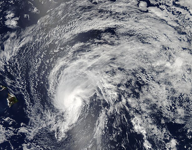
English: Not many tropical storms and hurricanes form in the central Pacific Ocean. Even fewer affect the Hawaiian Islands—just eight since 1979, according to meteorologist Jeff Masters. None have made direct landfall on the islands since Hurricane Iniki in 1992. That could change today if Tropical Storm Flossie maintains its strength.
The Moderate Resolution Imaging Spectroradiometer (MODIS) on NASA’s Aqua satellite acquired this image of Flossie at 1:10 p.m. local time (23:10 Universal Time) on July 28, 2013. Roughly two hours before the MODIS image was taken, the storm was centered at 19.9° North, 148.5° West. At the time, Flossie had sustained winds of roughly 60 miles per hour (50 knots or 90 kilometers per hour) and a pressure of 996 millibars. The storm was moving westward across the Pacific Ocean at roughly 20 miles per hour, headed for the Hawaiian Islands. By 8 a.m. local time on July 29, Flossie’s sustained winds were at 40 miles per hour (35 knots, or 65 kilometers). The storm was expected to make landfall on Monday evening, either on the “Big Island” of Hawaii or on Maui. Winds were expecting to be roughly 40 miles per hour, with gusts to 50 mph. Forecasters were more concerned about rainfall, which could reach 6 to 10 inches (15 to 25 centimeters) in a six- to eight-hour period, leading to landslides and floods. Tropical storm warnings or watches were in effect for all eight of the major islands. |
| 日期 | |
| 來源 | https://lance.modaps.eosdis.nasa.gov/cgi-bin/imagery/single.cgi?image=Flossie.A2013209.2310.2km.jpg |
| 作者 | NASA image courtesy Jeff Schmaltz, LANCE/EOSDIS MODIS Rapid Response Team at NASA GSFC. Caption by Mike Carlowicz. |
| 其他版本 |
.jpg)
授權條款
| 本作品由NASA創作,屬於公有領域。根據NASA的版權政策:“NASA的創作除非另有聲明否則不受版權保護。”(參見:Template:PD-USGov/zh,NASA版權政策或JPL圖像使用政策) | ||
 |
警告:
|
檔案歷史
點選日期/時間以檢視該時間的檔案版本。
| 日期/時間 | 縮圖 | 尺寸 | 使用者 | 備註 | |
|---|---|---|---|---|---|
| 目前 | 2016年12月16日 (五) 23:57 | | 8,200 × 6,400(8.4 MB) | Nino Marakot | Reverted to version as of 22:17, 30 October 2015 (UTC)- The size is too little and do not exceed 1.0 mb and above. |
| 2016年12月3日 (六) 07:46 |  | 1,460 × 1,864(561 KB) | Typhoon2013 | not gallery :( but better size | |
| 2015年10月30日 (五) 22:17 |  | 8,200 × 6,400(8.4 MB) | Nino Marakot | true gallery | |
| 2013年8月9日 (五) 19:00 |  | 6,500 × 5,000(11.97 MB) | TheAustinMan | Gallery version. ( http://earthobservatory.nasa.gov/IOTD/view.php?id=81730 ) | |
| 2013年7月29日 (一) 04:07 |  | 6,900 × 6,900(17.82 MB) | HurricaneSpin | {{Information |Description ={{en|1=Tropical Storm Flossie approaching Hawaii on July 28, 2013.}} |Source =[http://rapidfire.sci.gsfc.nasa.gov/realtime] |Author =NASA/MODIS Rapid Response System |Date =2013-07-28 |Permission... |
檔案用途
下列6個頁面有用到此檔案:
全域檔案使用狀況
以下其他 wiki 使用了這個檔案:
- es.wikipedia.org 的使用狀況
- fr.wikipedia.org 的使用狀況
- ko.wikipedia.org 的使用狀況