
File:Hurricane Jova Oct 10 2011 1740Z.jpg

預覽大小:600 × 600 像素。 其他解析度:240 × 240 像素 | 480 × 480 像素 | 768 × 768 像素 | 1,024 × 1,024 像素 | 2,048 × 2,048 像素 | 5,760 × 5,760 像素。
原始檔案 (5,760 × 5,760 像素,檔案大小:4.18 MB,MIME 類型:image/jpeg)
摘要
| 描述 |
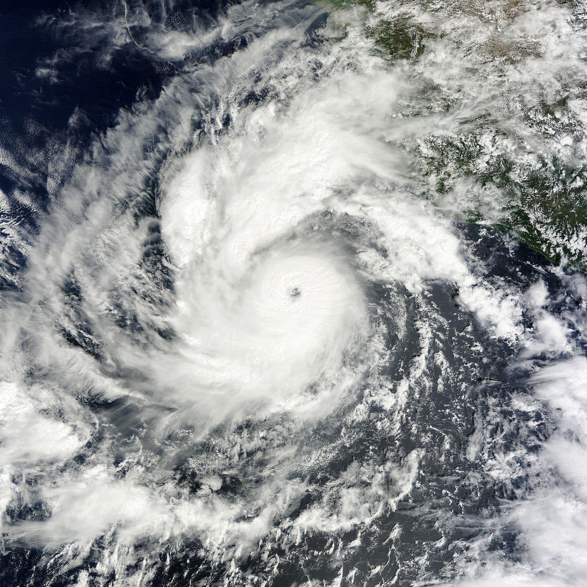
English: On October 6, 2011, a tropical depression over the eastern Pacific Ocean strengthened into Tropical Storm Jova. On October 8, it became a hurricane. By 11:00 a.m. Pacific Daylight Time (PDT) on October 10, 2011, the U.S. National Hurricane Center (NHC) reported that Jova was a Category 3 storm headed for the southwestern coast of Mexico.
The Moderate Resolution Imaging Spectroradiometer (MODIS) on NASA’s Terra satellite captured this natural-color image at 10:40 a.m. Pacific Daylight Time on October 10, 2011. Jova sports the spiral shape and distinct eye characteristic of strong storms. In the northeast quadrant, the storm’s clouds graze the coast of Mexico. As of 11:00 a.m. PDT on October 10, Jova had maximum sustained winds of 125 miles (205 kilometers) per hour, and was located roughly 220 miles (255 kilometers) southwest of Manzanillo, Mexico. A hurricane warning was in effect from Punta San Telmo north to Cabo Corrientes, and a tropical storm warning was in effect for Lazaro Cardenas north to Punta San Telmo. The NHC stated that the storm could become a Category 4 hurricane before making landfall on October 11. |
| 日期 | |
| 來源 | http://earthobservatory.nasa.gov/NaturalHazards/view.php?id=73873 |
| 作者 | NASA image courtesy MODIS Rapid Response Team, Goddard Space Flight Center. Caption by Michon Scott. |
授權條款
| 本作品由NASA創作,屬於公有領域。根據NASA的版權政策:“NASA的創作除非另有聲明否則不受版權保護。”(參見:Template:PD-USGov/zh,NASA版權政策或JPL圖像使用政策) | ||
 |
警告:
|
檔案歷史
點選日期/時間以檢視該時間的檔案版本。
| 日期/時間 | 縮圖 | 尺寸 | 使用者 | 備註 | |
|---|---|---|---|---|---|
| 目前 | 2019年1月6日 (日) 21:45 | | 5,760 × 5,760(4.18 MB) | David Levy | cropped |
| 2011年10月10日 (一) 20:59 |  | 5,760 × 6,000(4.67 MB) | Supportstorm | {{Information |Description ={{en|1=Hurricane Jova on October 10, 2011}} |Source =http://lance-modis.eosdis.nasa.gov/wms/?zoom=5&lat=19.20117&lon=-105.74414&layers=B0000FFFFFFT&datum1=10/10/2011 |Author =NASA, MODIS Rapid Response System |
檔案用途
下列頁面有用到此檔案:
全域檔案使用狀況
以下其他 wiki 使用了這個檔案:
- de.wikipedia.org 的使用狀況
- en.wikipedia.org 的使用狀況
- ko.wikipedia.org 的使用狀況