
File:India and Neighbouring Countries Map (official borders).png

預覽大小:575 × 600 像素。 其他解析度:230 × 240 像素 | 460 × 480 像素 | 795 × 829 像素。
原始檔案 (795 × 829 像素,檔案大小:218 KB,MIME 類型:image/png)
.png?uselang=zh-hant)
.png?uselang=zh-hant)
.png?action=history&uselang=zh-hant)
.png)
摘要
| 描述 |
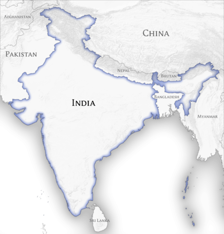
English: Map showing the official borders and neighbouring countries of the en:Republic of India as recognized by the Indian Government. The actual border of control varies from the official one in the en:Kashmir region which is controlled partly by India, Pakistan and China. |
||
| 日期 | |||
| 來源 | 自己的作品 | ||
| 作者 |
|
授權條款
| NATIONAL INSTITUTE OF DESIGN Bangalore Campus This is a work of a student or faculty from the National Institute of Design (India), 2024 |
CC-by-sa Arun Ganesh, National Institute of Design Bangalore
|
此檔案採用創用CC 姓名標示-相同方式分享 3.0 未在地化版本授權條款。
- 您可以自由:
- 分享 – 複製、發佈和傳播本作品
- 重新修改 – 創作演繹作品
- 惟需遵照下列條件:
- 姓名標示 – 您必須指名出正確的製作者,和提供授權條款的連結,以及表示是否有對內容上做出變更。您可以用任何合理的方式來行動,但不得以任何方式表明授權條款是對您許可或是由您所使用。
- 相同方式分享 – 如果您利用本素材進行再混合、轉換或創作,您必須基於如同原先的相同或兼容的條款,來分布您的貢獻成品。
檔案歷史
點選日期/時間以檢視該時間的檔案版本。
| 日期/時間 | 縮圖 | 尺寸 | 使用者 | 備註 | |
|---|---|---|---|---|---|
| 目前 | 2011年8月23日 (二) 07:26 | | 795 × 829(218 KB) | Planemad |
檔案用途
下列2個頁面有用到此檔案:
全域檔案使用狀況
以下其他 wiki 使用了這個檔案:
- en.wikipedia.org 的使用狀況
.png)