
File:Indonesia, administrative divisions - en - monochrome.svg

此 SVG 檔案的 PNG 預覽的大小:800 × 367 像素。 其他解析度:320 × 147 像素 | 640 × 293 像素 | 1,024 × 469 像素 | 1,280 × 587 像素 | 2,560 × 1,173 像素 | 982 × 450 像素。
原始檔案 (SVG 檔案,表面大小:982 × 450 像素,檔案大小:909 KB)
| 描述 |
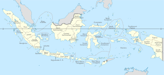
English: Indonesia provinces map (in Malgache)
Français : Carte des provinces indonésiennes (en malgache) Deutsch: Karte der indonesischen Provinzen Malagasy : Saritanin'ny faritany indonezianina (amin'ny fiteny malagasy) |
| 日期 | (UTC) |
| 來源 | |
| 作者 |
|
| 其他版本 |
|
| SVG開發 |


此檔案採用創用CC 姓名標示-相同方式分享 3.0 未在地化版本授權條款。
- 您可以自由:
- 分享 – 複製、發佈和傳播本作品
- 重新修改 – 創作演繹作品
- 惟需遵照下列條件:
- 姓名標示 – 您必須指名出正確的製作者,和提供授權條款的連結,以及表示是否有對內容上做出變更。您可以用任何合理的方式來行動,但不得以任何方式表明授權條款是對您許可或是由您所使用。
- 相同方式分享 – 如果您利用本素材進行再混合、轉換或創作,您必須基於如同原先的相同或兼容的條款,來分布您的貢獻成品。
原始上傳日誌
This image is a derivative work of the following images:
- File:Indonesia, administrative divisions - mg - monochrome.svg licensed with Cc-by-sa-3.0,2.5,2.0,1.0, GFDL
- 2010-02-04T05:32:46Z Queix 1322x620 (326516 Bytes) Modifying of foreign area's castline
- 2010-02-03T18:37:53Z Queix 1322x620 (325080 Bytes) {{Information |Description={{en|1=Indonesia provinces map (in French)}} {{fr|1=Carte des provinces indonésiennes (en français)}} |Source=*[[:File:Indonesia_provinces_map-fr.svg|]] |Date=2010-02-03 18:34 (UTC) |Author=*[[:Fi
- 2010-02-02T21:42:13Z Queix 1322x620 (319665 Bytes) '
- 2010-02-02T21:32:37Z Queix 1322x620 (319755 Bytes) '
- 2010-02-02T21:29:23Z Queix 1322x620 (319852 Bytes) '
- 2010-02-02T18:56:04Z Queix 1322x620 (319689 Bytes) {{Information |Description={{en|1=Indonesia provinces map (in Malgache)}} {{fr|1= Carte des provinces indonésiennes (en malgache)}} |Source=Travail personnel (own work) |Author=Sardon |Date=02/02/2010 |Permission= |other_ver
- File:Indonesia_provinces_english.png licensed with Cc-by-2.5, Cc-by-sa-3.0-migrated, GFDL
- 2006-01-08T07:54:20Z Golbez 1500x590 (78783 Bytes) Map of the provinces of Indonesian in English. Made by [[User:Golbez]] based on a PD CIA map, using other sources to guesstimate the extent of West Irian Jaya and West Sulawesi. [[Category:Maps of Indonesia]]
Uploaded with derivativeFX
檔案歷史
點選日期/時間以檢視該時間的檔案版本。
| 日期/時間 | 縮圖 | 尺寸 | 使用者 | 備註 | |
|---|---|---|---|---|---|
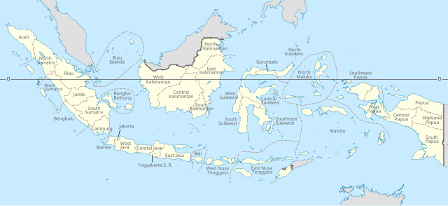
| 目前 | 2022年12月4日 (日) 16:09 | | 982 × 450(909 KB) | NordNordWest | adding Southwest Papua |
| 2022年8月21日 (日) 03:03 |  | 982 × 450(737 KB) | Afrogindahood | Addition of new provinces in Western New Guinea | |
| 2022年7月24日 (日) 09:04 |  | 982 × 450(954 KB) | Qexypnos | Reverted to version as of 21:38, 14 August 2021 (UTC) | |
| 2022年7月22日 (五) 20:43 |  | 2,560 × 1,170(824 KB) | Qexypnos | map correction | |
| 2022年7月22日 (五) 20:34 |  | 2,560 × 1,170(824 KB) | Qexypnos | added provinces of Highland Papua, South Papua, Central Papua | |
| 2021年8月14日 (六) 21:38 |  | 982 × 450(954 KB) | Afrogindahood | Minor resolution readjustment | |
| 2020年10月22日 (四) 13:47 |  | 786 × 360(731 KB) | Afrogindahood | Addition of North Kalimantan province | |
| 2011年1月21日 (五) 13:48 |  | 1,322 × 620(318 KB) | Yug | Font size | |
| 2011年1月21日 (五) 13:33 |  | 1,322 × 620(319 KB) | Yug | bug fix trial 4 | |
| 2011年1月21日 (五) 13:30 |  | 1,322 × 620(319 KB) | Yug | buf fix trial 3 |
檔案用途
下列頁面有用到此檔案:
全域檔案使用狀況
以下其他 wiki 使用了這個檔案:
- ace.wikipedia.org 的使用狀況
- an.wikipedia.org 的使用狀況
- ar.wikipedia.org 的使用狀況
- ban.wikipedia.org 的使用狀況
- bbc.wikipedia.org 的使用狀況
- bg.wikipedia.org 的使用狀況
- bn.wikipedia.org 的使用狀況
- bs.wikipedia.org 的使用狀況
- cs.wikipedia.org 的使用狀況
- en.wikipedia.org 的使用狀況
- frp.wikipedia.org 的使用狀況
- he.wikipedia.org 的使用狀況
- id.wikipedia.org 的使用狀況
- id.wikibooks.org 的使用狀況
- ja.wikipedia.org 的使用狀況
- lt.wikipedia.org 的使用狀況
- mg.wikipedia.org 的使用狀況
- pt.wikipedia.org 的使用狀況
- ro.wikipedia.org 的使用狀況
- simple.wikipedia.org 的使用狀況
- sq.wikipedia.org 的使用狀況
- tl.wikipedia.org 的使用狀況
- tr.wikipedia.org 的使用狀況
- uk.wikipedia.org 的使用狀況
- vec.wikipedia.org 的使用狀況
- vi.wikipedia.org 的使用狀況