
File:Karte NOE Viertel Bezirke.svg

此 SVG 檔案的 PNG 預覽的大小:666 × 599 像素。 其他解析度:267 × 240 像素 | 533 × 480 像素 | 853 × 768 像素 | 1,138 × 1,024 像素 | 2,276 × 2,048 像素 | 1,000 × 900 像素。
原始檔案 (SVG 檔案,表面大小:1,000 × 900 像素,檔案大小:82 KB)
摘要
| 描述 |
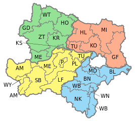
English: Map of Lower Austria showing districts with different colors for Waldviertel, Weinviertel, Mostviertel and Industrieviertel.
Deutsch: Karte von Niederösterreich, eingezeichnet die Bezirke und die vier Viertel: Waldviertel, Weinviertel, Mostviertel und Industrieviertel.
Waldviertel
Weinviertel
Mostviertel
Industrieviertel |
| 日期 | |
| 來源 | Own work, based on [1] |
| 作者 | AleXXw |
| 其他版本 |
|


![[1]](http://www.noe.gv.at/bilder/d17/BD5noe31-Viertelsgrenzen.png?7150)
授權條款
| 我,此作品的版權所有人,釋出此作品至公共領域。此授權條款在全世界均適用。 這可能在某些國家不合法,如果是的話: 我授予任何人有權利使用此作品於任何用途,除受法律約束外,不受任何限制。 |
檔案歷史
點選日期/時間以檢視該時間的檔案版本。
| 日期/時間 | 縮圖 | 尺寸 | 使用者 | 備註 | |
|---|---|---|---|---|---|
| 目前 | 2017年2月4日 (六) 15:26 | | 1,000 × 900(82 KB) | Ailura | Versuch ohne WU |
| 2017年2月4日 (六) 14:23 |  | 1,000 × 900(67 KB) | FDMS4 | Reverted to version as of 22:24, 16 February 2015 (UTC): not a vector file; parts of Viertel border missing | |
| 2017年1月3日 (二) 14:42 |  | 420 × 378(131 KB) | Kontrollstellekundl | 2017 -WU | |
| 2015年2月16日 (一) 22:24 |  | 1,000 × 900(67 KB) | Ailura | - SW | |
| 2015年2月16日 (一) 22:22 |  | 1,000 × 900(67 KB) | Ailura | SW ist kein bezirk | |
| 2015年2月14日 (六) 22:10 |  | 1,000 × 900(67 KB) | Ailura | Layers | |
| 2009年5月7日 (四) 18:30 |  | 1,000 × 900(93 KB) | AleXXw | {{Information |Description= {{en|Map of Lower Austria showing districts with different colors for Waldviertel, Weinviertel, Mostviertel and Industrieviertel.}} {{de|Karte von Niederösterreich, eingezeichnet die Bezirke und die vie |
檔案用途
下列25個頁面有用到此檔案:
全域檔案使用狀況
以下其他 wiki 使用了這個檔案:
- cs.wikipedia.org 的使用狀況
- de.wikipedia.org 的使用狀況
- en.wikipedia.org 的使用狀況
- Sankt Pölten
- Krems an der Donau
- Wiener Neustadt
- Melk District
- Template:Lower Austria
- Waidhofen an der Ybbs
- Korneuburg District
- Amstetten District
- Baden District, Austria
- Bruck an der Leitha District
- Gänserndorf District
- Gmünd District
- Hollabrunn District
- Horn District
- Krems District
- Lilienfeld District
- Mistelbach District
- Mödling District
- St. Pölten District
- Scheibbs District
- Tulln District
- Waidhofen an der Thaya District
- Wiener Neustadt District
- Zwettl District
- Neunkirchen District, Austria
- Wikipedia:WikiProject Navigation templates/Country subdivisions/Austria
- eo.wikipedia.org 的使用狀況
- es.wikipedia.org 的使用狀況
- fr.wikipedia.org 的使用狀況
- io.wikipedia.org 的使用狀況
- it.wikipedia.org 的使用狀況
- mk.wikipedia.org 的使用狀況
- mn.wikipedia.org 的使用狀況
- pt.wikipedia.org 的使用狀況
檢視此檔案的更多全域使用狀況。