
File:Litoral argentino.svg

此 SVG 檔案的 PNG 預覽的大小:257 × 600 像素。 其他解析度:103 × 240 像素 | 205 × 480 像素 | 329 × 768 像素 | 439 × 1,024 像素 | 877 × 2,048 像素 | 465 × 1,085 像素。
原始檔案 (SVG 檔案,表面大小:465 × 1,085 像素,檔案大小:544 KB)
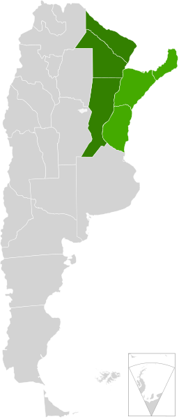
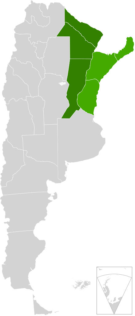
| 描述 | A map of Argentina, in scalable vector form, showing the provinces from the "Litoral argentino" |
| 日期 | (UTC) |
| 來源 | |
| 作者 |
|
| 這是一張修飾過的圖片,即本圖片是用軟體修改過後的版本。原版圖片來源:Blank Argentina Map.svg。修改者:Mahadeva。
|
我,本作品的著作權持有者,決定用以下授權條款發佈本作品:
此檔案採用創用CC 姓名標示-相同方式分享 3.0 未在地化版本授權條款。
- 您可以自由:
- 分享 – 複製、發佈和傳播本作品
- 重新修改 – 創作演繹作品
- 惟需遵照下列條件:
- 姓名標示 – 您必須指名出正確的製作者,和提供授權條款的連結,以及表示是否有對內容上做出變更。您可以用任何合理的方式來行動,但不得以任何方式表明授權條款是對您許可或是由您所使用。
- 相同方式分享 – 如果您利用本素材進行再混合、轉換或創作,您必須基於如同原先的相同或兼容的條款,來分布您的貢獻成品。
原始上傳日誌
This image is a derivative work of the following images:
- File:Blank_Argentina_Map.svg licensed with Cc-by-sa-3.0
- 2009-06-16T03:38:27Z Dexxter 465x1085 (556030 Bytes) minor corrections
- 2009-06-09T04:16:00Z Dexxter 475x1029 (571435 Bytes) size
- 2009-06-09T03:52:25Z Dexxter 475x1029 (653128 Bytes) darker background
- 2009-06-09T03:43:53Z Dexxter 475x1029 (560186 Bytes) == Summary == {{Information |Description=A blank map of Argentina in scalable vector form, including the territorials claims. |Source=Own work, based on the official cartography published by the Military Geographic Institute
Uploaded with derivativeFX
檔案歷史
點選日期/時間以檢視該時間的檔案版本。
| 日期/時間 | 縮圖 | 尺寸 | 使用者 | 備註 | |
|---|---|---|---|---|---|
| 目前 | 2010年8月4日 (三) 20:33 | | 465 × 1,085(544 KB) | Mahadeva | {{Information |Description=A map of Argentina, in scalable vector form, showing the provinces from the "Litoral argentino" |Source=*File:Blank_Argentina_Map.svg |Date=2010-08-04 20:32 (UTC) |Author=*File:Blank_Argentina_Map.svg: [[User:Dexxter |
檔案用途
下列頁面有用到此檔案:
全域檔案使用狀況
以下其他 wiki 使用了這個檔案:
- en.wikipedia.org 的使用狀況
- eo.wikipedia.org 的使用狀況
- es.wikipedia.org 的使用狀況
- fr.wikipedia.org 的使用狀況
- ja.wikipedia.org 的使用狀況