
File:Map Bolivia territorial loss-en.svg

此 SVG 檔案的 PNG 預覽的大小:375 × 355 像素。 其他解析度:254 × 240 像素 | 507 × 480 像素 | 811 × 768 像素 | 1,082 × 1,024 像素 | 2,163 × 2,048 像素。
原始檔案 (SVG 檔案,表面大小:375 × 355 像素,檔案大小:78 KB)
| 描述 |
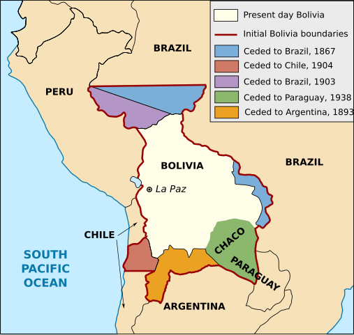
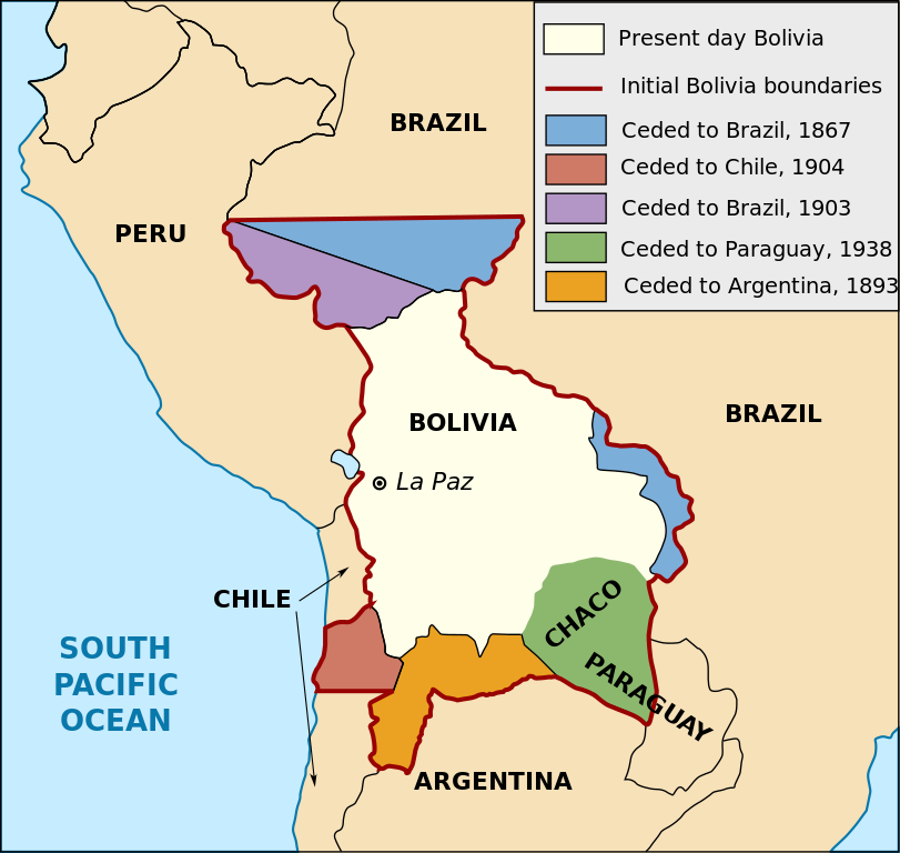
English: Territorial loss map of Bolivia |
| 日期 | (UTC) |
| 來源 | |
| 作者 |
|
| 其他版本 |
[]
此檔案衍生的作品: |


此作品在美國屬於公有領域,因為其是由美國政府的官員或僱員,基於其個人公務目的製作的作品,參考美國法典第17篇第1章第105條。
注意︰本模板僅適用於美國聯邦政府的原創作品,不適用於任何美國州、屬地、聯邦個體、縣、市或任何次級政府的作品。本模板也不適用於1978年以後由美國郵政署出版的郵票圖案(參看美國版權局實踐綱領第313.6(C)(1)條)。也不適用於部分美國硬幣;參看美國鑄幣局使用條款。 |
 | |
| 此作品無已知的著作權限制,亦不受所有相關和鄰接的權利限制。 | ||
檔案歷史
點選日期/時間以檢視該時間的檔案版本。
| 日期/時間 | 縮圖 | 尺寸 | 使用者 | 備註 | |
|---|---|---|---|---|---|
| 目前 | 2020年1月1日 (三) 16:19 | | 375 × 355(78 KB) | Janitoalevic | Added territory ceded to Argentina |
| 2013年12月12日 (四) 18:48 |  | 375 × 355(68 KB) | Pethrus | Fixed ocean name | |
| 2010年5月4日 (二) 16:07 |  | 375 × 355(68 KB) | Naturals | The territory of Paraguay was reversed with the territory of Brazil | |
| 2010年5月3日 (一) 19:06 |  | 375 × 355(69 KB) | Pethrus | Paraguay border fixed | |
| 2010年5月3日 (一) 19:02 |  | 375 × 355(69 KB) | Pethrus | Fixed bugs | |
| 2010年5月3日 (一) 18:56 |  | 375 × 355(79 KB) | Pethrus | Inkscape bugs fixed | |
| 2010年5月3日 (一) 18:53 |  | 375 × 355(81 KB) | Pethrus | {{Information |Description={{en|Territorial loss map of Bolivia}} |Source=*File:Bolivia_territorial_loss_map_LOC.jpg |Date=2010-05-03 18:51 (UTC) |Author=*File:Bolivia_territorial_loss_map_LOC.jpg: Library of Congress Country Study on Bolivia |
檔案用途
下列頁面有用到此檔案:
全域檔案使用狀況
以下其他 wiki 使用了這個檔案:
- az.wikipedia.org 的使用狀況
- ca.wikipedia.org 的使用狀況
- cs.wikipedia.org 的使用狀況
- da.wikipedia.org 的使用狀況
- de.wikipedia.org 的使用狀況
- en.wikipedia.org 的使用狀況
- eu.wikipedia.org 的使用狀況
- fi.wikipedia.org 的使用狀況
- fr.wikipedia.org 的使用狀況
- hi.wikipedia.org 的使用狀況
- hi.wiktionary.org 的使用狀況
- id.wikipedia.org 的使用狀況
- it.wikipedia.org 的使用狀況
- ja.wikipedia.org 的使用狀況
- ka.wikipedia.org 的使用狀況
- ko.wikipedia.org 的使用狀況
- lt.wikipedia.org 的使用狀況
- nl.wikipedia.org 的使用狀況
- pl.wikipedia.org 的使用狀況
- pt.wikipedia.org 的使用狀況
- sat.wikipedia.org 的使用狀況
- sd.wikipedia.org 的使用狀況
- sk.wikipedia.org 的使用狀況
- te.wikipedia.org 的使用狀況