
File:Nahkealehtinen kasvillisuus.png

預覽大小:800 × 398 像素。 其他解析度:320 × 159 像素 | 640 × 318 像素 | 1,262 × 628 像素。
原始檔案 (1,262 × 628 像素,檔案大小:35 KB,MIME 類型:image/png)

|
已授權您依據自由軟體基金會發行的無固定段落、封面文字和封底文字GNU自由文件授權條款1.2版或任意後續版本,對本檔進行複製、傳播和/或修改。該協議的副本列在GNU自由文件授權條款中。 |
| 此檔案採用創用CC 姓名標示-相同方式分享 3.0 未在地化版本授權條款。 | ||
| 姓名標示: Vzb83 | ||
| ||
| 已新增授權條款標題至此檔案,作為GFDL授權更新的一部份。 |
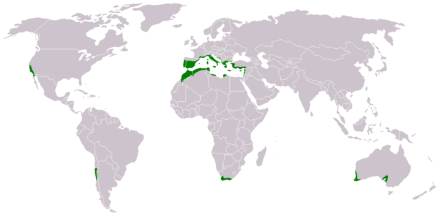
- Suomi: Nahkealehtisen eli välimerenkasvillisuuden levinneisyys.
- English: Distribution of Mediterranean forests, woodlands, and shrub biome.
Based on the blank world map BlankMap-World.png.
See also Image:Medclim.png and Image:Macchia mediterranea map.jpg.
檔案歷史
點選日期/時間以檢視該時間的檔案版本。
| 日期/時間 | 縮圖 | 尺寸 | 使用者 | 備註 | |
|---|---|---|---|---|---|
| 目前 | 2018年3月17日 (六) 15:34 | | 1,262 × 628(35 KB) | Maphobbyist | Montenegro border |
| 2011年7月9日 (六) 02:15 |  | 1,262 × 628(44 KB) | Maphobbyist | South Sudan has become independent on July 9, 2011. Sudan and South Sudan are shown with the new international border between them. | |
| 2010年6月11日 (五) 16:48 |  | 1,262 × 628(44 KB) | Maphobbyist | Little editing | |
| 2010年6月11日 (五) 14:35 |  | 1,262 × 628(44 KB) | Maphobbyist | Syria except the Mediterranean coastal area, Jordan, South Israel, Iraq, the Black Sea coast of Turkey and the Caspian Coast of Iran do not have a Mediterranean climate. The northwest coast of Libya including Tripoli,has a Mediterranean climate. | |
| 2007年2月13日 (二) 21:43 |  | 1,262 × 628(14 KB) | Hautala | {{GFDL-user-fi|Vzb83}} * {{fi|Nahkealehtisen eli välimerenkasvillisuuden levinneisyys.}} * {{en|Distribution of Mediterranean forests, woodlands, and shrub biome.}} Based on the blank world map Image:BlankMap-World.png. See also [[:Image:Medclim |
檔案用途
下列頁面有用到此檔案:
全域檔案使用狀況
以下其他 wiki 使用了這個檔案:
- an.wikipedia.org 的使用狀況
- ar.wikipedia.org 的使用狀況
- bs.wikipedia.org 的使用狀況
- ca.wikipedia.org 的使用狀況
- cs.wikipedia.org 的使用狀況
- da.wikipedia.org 的使用狀況
- eo.wikipedia.org 的使用狀況
- eu.wikipedia.org 的使用狀況
- fi.wikipedia.org 的使用狀況
- hr.wikipedia.org 的使用狀況
- ka.wikipedia.org 的使用狀況
- no.wikipedia.org 的使用狀況
- pt.wikipedia.org 的使用狀況
- sh.wikipedia.org 的使用狀況
- sr.wikipedia.org 的使用狀況