
File:Sunken Japanese battleship Ise off Ondo Seto island, circa in October 1945.jpg
無更高解析度可提供。
Sunken_Japanese_battleship_Ise_off_Ondo_Seto_island,_circa_in_October_1945.jpg (709 × 446 像素,檔案大小:164 KB,MIME 類型:image/jpeg)
摘要
| 描述 |
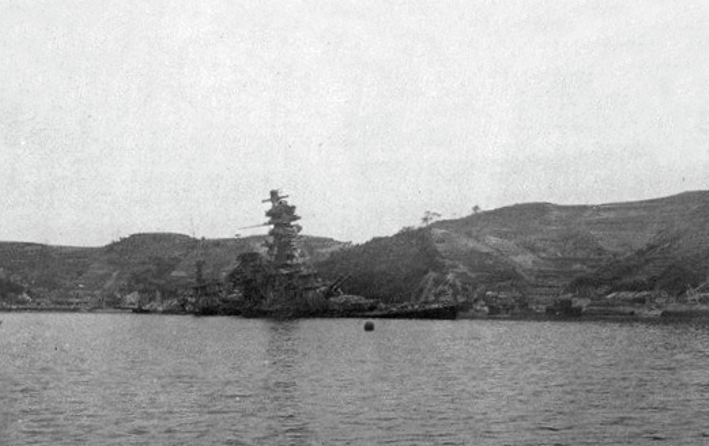
English: The sunken Japanese battleship Ise off Ondo Seto island, near the Kure Naval Arseanal, Japan, circa in October 1945. |
| 日期 | 約1945年10月 |
| 來源 | U.S. Navy photo [1] from the USS Montpelier (CL-57) World War II cruise book available at Navysite.de |
| 作者 | U.S. Navy |
| 拍攝地點 | | 位於此地的本圖片與其他圖片: OpenStreetMap |
|---|
授權條款
 | ||
| 此作品無已知的著作權限制,亦不受所有相關和鄰接的權利限制。 | ||
原始上傳日誌
The original description page was here. All following user names refer to en.wikipedia.
- 2006-01-08 03:32 RebelAt 583×298×8 (65827 bytes) Scanned in from a personal copy of the the official "War Diary of CL 57 U.S.S. Montpelier," published by the U.S. Navy Main page caption,"To the Japanese Navy: Bottoms Up." Picture caption says,"Battleship (with Flight Deck) Ise."
- 2006-01-08 03:28 RebelAt 777×397×8 (167028 bytes) Scanned in from a personal copy of the the official "War Diary of CL 57 U.S.S. Montpelier," published by the U.S. Navy Main page caption,"To the Japanese Navy: Bottoms Up." Picture caption says,"Battleship (with Flight Deck) Ise."
檔案歷史
點選日期/時間以檢視該時間的檔案版本。
| 日期/時間 | 縮圖 | 尺寸 | 使用者 | 備註 | |
|---|---|---|---|---|---|
| 目前 | 2018年9月15日 (六) 10:27 | | 709 × 446(164 KB) | Cobatfor | true grey scale |
| 2008年3月22日 (六) 13:34 |  | 583 × 298(64 KB) | Mifter | {{Information |Description={{en|Scanned in from a personal copy of the official "War Diary of CL 57 U.S.S. Montpelier," published by the U.S. Navy Main page caption,"To the Japanese Navy: Bottoms Up." Picture caption says,"Battleship (with Flight Deck) |
檔案用途
下列頁面有用到此檔案:
全域檔案使用狀況
以下其他 wiki 使用了這個檔案:
- ar.wikipedia.org 的使用狀況
- de.wikipedia.org 的使用狀況
- es.wikipedia.org 的使用狀況
- ja.wikipedia.org 的使用狀況
- no.wikipedia.org 的使用狀況
- vi.wikipedia.org 的使用狀況