
File:Lunar Thorium concentrations.jpg
預覽大小:800 × 419 像素。 其他解析度:320 × 168 像素 | 640 × 335 像素 | 1,024 × 536 像素 | 1,280 × 670 像素 | 2,100 × 1,100 像素。
原始檔案 (2,100 × 1,100 像素,檔案大小:817 KB,MIME 類型:image/jpeg)
| 描述 |
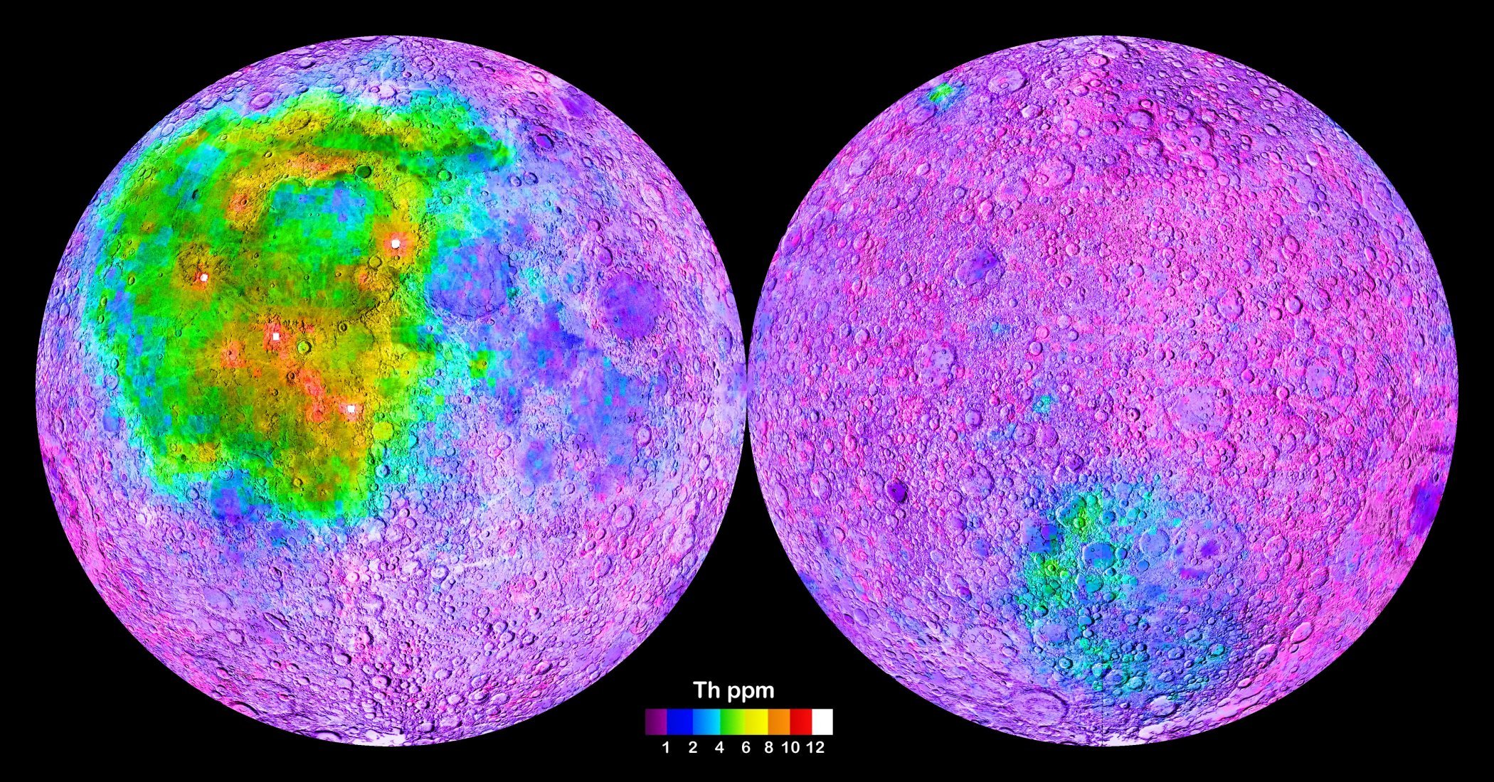
Map of the Moon (left: nearside; right: farside), generated from gamma-spectrometric data collected by the Lunar Prospector vessel. The map shows the global distribution of the element Thorium in surface rocks, with high Thorium concentrations indicating the occurence of the so-called KREEP rocks, which have high contents in Potassium, Rare Earth Elements and Phosphorus. The heterogeneous distribution of KREEP rocks at the moon’s surface implies fundamentally different geological histories of the individual lunar regions (terranes). For further information see Jolliff et al. (2000).[1]
|
|||||
| 日期 | 2012-05-22, original upload date on en.wikipedia.org was 2012-08-28. Uploaded version is identical to the version transferred to commons. | |||||
| 來源 | http://solarsystem.nasa.gov/multimedia/display.cfm?Category=Planets&IM_ID=13643 | |||||
| 作者 | NASA | |||||
| 授權許可 (重用此檔案) |
|

| 註解 | 該圖片含有註解:在維基媒體共享資源上查看註解 |
檔案歷史
點選日期/時間以檢視該時間的檔案版本。
| 日期/時間 | 縮圖 | 尺寸 | 用戶 | 備註 | |
|---|---|---|---|---|---|
| 目前 | 2014年5月19日 (一) 21:20 | | 2,100 × 1,100(817 KB) | Gretarsson | {{Information |Description = Map of the Moon, generated from data collected by the Lunar Prospector vessel. The map shows the global distribution of the element Thorium in surface rocks, with high Thorium concentrations indicating the occurence of the... |
檔案用途
全域檔案使用狀況
以下其他 wiki 使用了這個檔案:
- ba.wikipedia.org 的使用狀況
- cv.wikipedia.org 的使用狀況
- de.wikipedia.org 的使用狀況
- en.wikipedia.org 的使用狀況
- es.wikipedia.org 的使用狀況
- eu.wikipedia.org 的使用狀況
- fr.wikipedia.org 的使用狀況
- fr.wikibooks.org 的使用狀況
- id.wikipedia.org 的使用狀況
- it.wikipedia.org 的使用狀況
- ko.wikipedia.org 的使用狀況
- kw.wikipedia.org 的使用狀況
- nl.wikipedia.org 的使用狀況
- pt.wikipedia.org 的使用狀況
- ro.wikipedia.org 的使用狀況
- ru.wikipedia.org 的使用狀況
- uk.wikipedia.org 的使用狀況