
File:Map Denmark Demis SE islands.gif
此為最大尺寸。
Map_Denmark_Demis_SE_islands.gif (415 × 420 像素,檔案大小:23 KB,MIME 類型:image/gif)
摘要
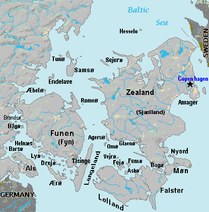
| 描述 | Terrain map of southeast Denmark, showing the major islands labeled, in the region between Germany and Sweden. The terrain data was extracted from the Demis map (on Wikimedia Commons) Image:La2-demis-denmark.png, and the extracted map was color-shifted to grayshade land areas (from the green Demis map). Labels are in font face Arial or Arial Narrow, sizes 8-10. |
| 日期 | |
| 來源 | Derivative of Demis map: Image:La2-demis-denmark.png |
| 作者 | Wikid77 (derivative of Demis map) |
授權條款
This image is in the public domain because it came from the site https://www.demis.nl/products/web-map-server/examples/ and was released by the copyright holder. Permission is granted to copy, distribute and/or modify this map since it is based on free of copyright images from: www.demis.nl. See also approval email on de.wp and its clarification.
|
| This work has been released into the public domain by its copyright holder, www.demis.nl. This applies worldwide. 這可能在某些國家不合法,如果是的話: www.demis.nl授予任何人有權利使用此作品於任何用途,除受法律約束外,不受任何限制。
|
檔案歷史
點選日期/時間以檢視該時間的檔案版本。
| 日期/時間 | 縮圖 | 尺寸 | 用戶 | 備註 | |
|---|---|---|---|---|---|
| 目前 | 2007年9月3日 (一) 18:51 | | 415 × 420(23 KB) | Wikid77 | added 14 island names |
| 2007年9月2日 (日) 10:50 |  | 415 × 420(22 KB) | Wikid77 | added "Sejero" + "Amager" | |
| 2007年9月1日 (六) 12:56 |  | 415 × 420(22 KB) | Wikid77 | cut height 10px for square/undistorted resizing; cut banner "DENMARK" to appear in banner version | |
| 2007年9月1日 (六) 12:46 |  | 415 × 430(22 KB) | Wikid77 | cut map width 10px as 415px magnified 3%; banner "DENMARK"; enlarged names; darkened Germany/Sweden | |
| 2007年8月31日 (五) 13:36 |  | 425 × 430(22 KB) | Wikid77 | Terrain map of southeast Denmark, showing the major islands labeled, in the region between Germany and Sweden. The terrain data was extracted from the Demis map (on Wikimedia Commons) Image:La2-demis-denmark.png , and the extracted map w |
檔案用途
下列頁面有用到此檔案:
全域檔案使用狀況
以下其他 wiki 使用了這個檔案:
- da.wikipedia.org 的使用狀況
- el.wikipedia.org 的使用狀況
- en.wikipedia.org 的使用狀況
- es.wikipedia.org 的使用狀況
- fi.wikipedia.org 的使用狀況
- fr.wikipedia.org 的使用狀況
- gl.wikipedia.org 的使用狀況
- hr.wikipedia.org 的使用狀況
- it.wikipedia.org 的使用狀況
- ka.wikipedia.org 的使用狀況
- la.wikipedia.org 的使用狀況
- lt.wikipedia.org 的使用狀況
- pt.wikipedia.org 的使用狀況
- sl.wikipedia.org 的使用狀況
- vi.wikipedia.org 的使用狀況