
File:Marcellinus Dalmatia.jpg

預覽大小:607 × 600 像素。 其他解析度:243 × 240 像素 | 486 × 480 像素 | 778 × 768 像素 | 1,054 × 1,041 像素。
原始檔案 (1,054 × 1,041 像素,檔案大小:98 KB,MIME 類型:image/jpeg)
摘要
| 描述 |
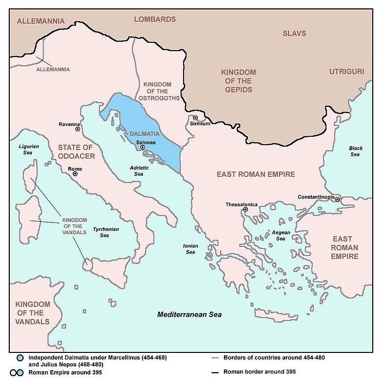
English: Independent Dalmatia - Extent of Marcellinus' Control (454-468) and Julius Nepos' Control (468-480). Srpskohrvatski / српскохрватски: Nezavisna Dalmacija - Područje pod kontrolom Marcelina (454-468) i Julija Nepota (468-480). |
| 日期 | 2007年二月18日 (原始上傳日期) |
| 來源 | Map is based on this one made by User:PANONIAN: http://en.wikipedia.org/wiki/Image:Prefecture.png |
| 作者 | 英文維基百科的Neos Dionysos |
| 其他版本 |
|

授權條款
| 此作品已由其作者,英文維基百科的Neos Dionysos,釋出至公有領域。此授權條款在全世界均適用。 這可能在某些國家不合法,如果是的話: Neos Dionysos授予任何人有權利使用此作品於任何用途,除受法律約束外,不受任何限制。 |
References
Primary source:
- Based on this source: Dragan Brujić, Vodič kroz svet Vizantije, Beograd, 2004. (Online version: [1] archive copy at the Wayback Machine, pages 11 and 13)
Secondary sources:
- http://pages.uoregon.edu/mapplace/EU/EU19%20-%20Italy/Maps/EU19_07.jpg
- http://www.emersonkent.com/images/europe_476.jpg
- http://recklessbooks.co.uk/communities/9/004/007/811/829/images/4535699992_525x369.jpg
- http://recklessbooks.co.uk/#/34-puppet-emperors/4542500399
- http://i251.photobucket.com/albums/gg311/beebybooks/Spruner/IMG_4017.jpg (Note: image from Photobucket used only as a secondary reference)
- http://4.bp.blogspot.com/-yRv7usvddEI/TogNM7bUU5I/AAAAAAAAChA/0XBMB4dQyzA/s1600/europeantribes5thC.jpg
- http://waucondastore.com/wp-content/uploads/2012/10/The-Germanic-invasions-410-1066.jpg
- http://www.heritage-history.com/maps/philips/phil002.jpg
- http://rbedrosian.com/Maps/muhamm6a.jpg
- http://www.miklianmaps.com/images/1876%20Norstedt%2008%20europe%20476.jpg
- http://www.historyandcivilization.com/Peoples___Kingdoms_in_the_West_c_476AD.jpg
- http://0.tqn.com/d/historymedren/1/0/G/N/2/ms476europe.jpg
- http://fc06.deviantart.net/fs71/i/2013/132/2/9/the_end_of_the_western_roman_empire__ad_476__by_undevicesimus-d5tem60.jpg
- http://upload.wikimedia.org/wikipedia/commons/thumb/b/b5/Vandali.jpg/744px-Vandali.jpg
- http://www.enciklopedija.hr/Ilustracije/Dalmacija_u_doba_rimljana.jpg
原始上傳日誌
Transferred from en.wikipedia to Commons by BokicaK using CommonsHelper.
The original description page was here. All following user names refer to en.wikipedia.
- 2007-02-18 21:34 Neos Dionysos 1054×1041× (126215 bytes) Extent of Marcellinus' Control. I found this picture on another wiki page which was made from scratch and so I edited it to fit the needs I for this article.
檔案歷史
點選日期/時間以檢視該時間的檔案版本。
| 日期/時間 | 縮圖 | 尺寸 | 用戶 | 備註 | |
|---|---|---|---|---|---|
| 目前 | 2013年6月27日 (四) 23:38 | | 1,054 × 1,041(98 KB) | PANONIAN | addition |
| 2013年6月27日 (四) 23:01 |  | 1,054 × 1,041(96 KB) | PANONIAN | fixed year | |
| 2013年6月27日 (四) 22:35 |  | 1,054 × 1,041(96 KB) | PANONIAN | improved version, borders of Dalmatia based on this source: Dragan Brujić, Vodič kroz svet Vizantije, Beograd, 2004. | |
| 2013年3月7日 (四) 05:30 |  | 1,054 × 1,041(123 KB) | File Upload Bot (Magnus Manske) | Transfered from en.wikipedia by User:BokicaK using CommonsHelper |
檔案用途
下列頁面有用到此檔案:
全域檔案使用狀況
以下其他 wiki 使用了這個檔案:
- ar.wikipedia.org 的使用狀況
- azb.wikipedia.org 的使用狀況
- bg.wikipedia.org 的使用狀況
- bs.wikipedia.org 的使用狀況
- ca.wikipedia.org 的使用狀況
- cs.wikipedia.org 的使用狀況
- da.wikipedia.org 的使用狀況
- de.wikipedia.org 的使用狀況
- el.wikipedia.org 的使用狀況
- en.wikipedia.org 的使用狀況
- es.wikipedia.org 的使用狀況
- fr.wikipedia.org 的使用狀況
- gl.wikipedia.org 的使用狀況
- hr.wikipedia.org 的使用狀況
- hy.wikipedia.org 的使用狀況
- is.wikipedia.org 的使用狀況
- it.wikipedia.org 的使用狀況
- nl.wikipedia.org 的使用狀況
- no.wikipedia.org 的使用狀況
- ru.wikipedia.org 的使用狀況
- sh.wikipedia.org 的使用狀況
- sq.wikipedia.org 的使用狀況
- sr.wikipedia.org 的使用狀況
- sv.wikipedia.org 的使用狀況
- tr.wikipedia.org 的使用狀況
- www.wikidata.org 的使用狀況