跳至內容

File:Nova totius Terrarum Orbis geographica ac hydrographica tabula (Hendrik Hondius) balanced.jpg

頁面內容不支援其他語言。
這個檔案來自維基共享資源
維基百科,自由的百科全書

原始檔案(5,248 × 3,688 像素,檔案大小:5.3 MB,MIME 類型:image/jpeg


摘要

Jodocus Hondius II:​Nova totius terrarum orbis geographica ac hydrographica tabula  wikidata:Q120597485 reasonator:Q120597485
作家
Jodocus Hondius II  (1593–1629)  wikidata:Q21016928
 
描述 荷蘭雕刻師、​製圖師、​編輯、​instrument maker、​medical instrument maker以及版畫家
出生/逝世日期 1593年十一月 在維基數據編輯 1629年八月 在維基數據編輯
出生/逝世地點 阿姆斯特丹 阿姆斯特丹
創作地點
阿姆斯特丹 (1612年–1633年) 在維基數據編輯
權威檔案
creator QS:P170,Q21016928
 在維基數據編輯
image of artwork listed in title parameter on this page
作者
亨里克斯·洪第烏斯二世  (1597–1651)  wikidata:Q983261
 
別名
Hendrick Hondius, Henricus Hondius II, Hendrik Hondius the Younger
描述 西班牙-荷蘭製圖師、​出版商、​版畫家、​畫家以及書商
出生/逝世日期 1597年 在維基數據編輯 1651年八月16日 在維基數據編輯
出生/逝世地點 阿姆斯特丹 阿姆斯特丹
作品年代 1612年 在維基數據編輯–1644年 在維基數據編輯
創作地點
權威檔案
creator QS:P170,Q983261
標題
拉丁文:
Nova Totius Terrarum Orbis Geographica ac Hydrographica Tabula

New Geographic and Hydrographic Map of the Whole World
title QS:P1476,la:"Nova Totius Terrarum Orbis Geographica ac Hydrographica Tabula"
label QS:Lla,"Nova Totius Terrarum Orbis Geographica ac Hydrographica Tabula"
label QS:Len,"New Geographic and Hydrographic Map of the Whole World"
出版商
物體類型 世界地圖 / antique map / manuscript map / double hemisphere world map / 早期世界地圖 在維基數據編輯
藝術類型 地圖 在維基數據編輯
描述

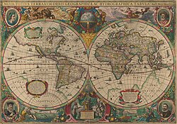
This is an image of Nova totius Terrarum Orbis geographica ac hydrographica tabula, a map of the world created by Hendrik Hondius in 1630, and published the following year in the atlas Atlantis Maioris Appendix.

Among its claims to notability is the fact that it was the first dated map published in an atlas, and therefore the first widely available map, to show any part of Australia, the only previous map to do so being Hessel Gerritsz' 1627 Caert van't Landt van d'Eendracht ("Chart of the Land of Eendracht"), which was not widely distributed.

The Australian coastline shown is part of the west coast of Cape York Peninsula, discovered by Jan Carstensz in 1623. Curiously, the map does not show the west coast features shown in Gerritsz' Caert.
語言 拉丁語 在維基數據編輯
日期 The original map was executed in 1630, and published in 1631.
出版日期 1630年 在維基數據編輯
尺寸 高度:​54釐米 在維基數據編輯;​寬度:​38釐米 在維基數據編輯
dimensions QS:P2048,+54U174728
dimensions QS:P2049,+38U174728
institution QS:P195,Q111677119
出版地 不明 在維基數據編輯
來源/攝影者 This is a scan of the copy belonging to the State Library of New South Wales. Access to it is available at http://image.sl.nsw.gov.au/cgi-bin/ebindshow.pl?doc=heritage/a1439;seq=13. The graphical user interface provided does not support downloading the full image at full resolution, but the back end can be cajoled to do so by manually editing the CGI arguments in the url, to http://image.sl.nsw.gov.au/cgi-bin/mrsid/image_jpeg.pl?client=heritage/a1439&image=a128994.sid&x=2624&y=1844&level=0&width=5248&height=3688.
其他版本 This is a colour-balanced version; the original version is at Image:Nova totius Terrarum Orbis geographica ac hydrographica tabula (Hendrik Hondius).jpg

授權條款

此為如實地拍攝平面藝術品的相片複製本。原作位於公有領域,是因下列原因:
Public domain

本作品在其來源國以及其他版權期限是作者逝世後100年或以下的國家與地區屬於公有領域


你必須增加美國公有領域標籤顯示為何這個作品在美國屬於公有領域。
維基媒體基金會的官方立場認為:「針對平面公有領域的藝術作品進行忠實重製,其重製後的照片也屬於公有領域。」
因此,可認定本重製照片屬於公有領域。在其他司法管轄區,再利用此照片可能會被限制;參見再利用PD-Art照片以獲得進一步資訊。

說明

添加單行說明來描述出檔案所代表的內容
Early Double Hemisphere World Map.

在此檔案描寫的項目

描繪內容

近代史 中文 (已轉換拼寫)

檔案歷史

點選日期/時間以檢視該時間的檔案版本。

日期/時間縮⁠圖尺寸用戶備⁠註
目前2008年2月6日 (三) 23:09於 2008年2月6日 (三) 23:09 版本的縮圖5,248 × 3,688(5.3 MB)Hesperian{{Information |Description=This is an image of ''Nova totius Terrarum Orbis geographica ac hydrographica tabula'', a map of the world created by Hendrik Hondius in 1630, and published the following year in the atlas ''Atlantis Maioris Appendix

下列頁面有用到此檔案:

全域檔案使用狀況

以下其他 wiki 使用了這個檔案:

檢視此檔案的更多全域使用狀況

詮釋資料