
File:Syrtis-Isidis zoom 64 pano.jpg

預覽大小:800 × 556 像素。 其他解析度:320 × 222 像素 | 640 × 444 像素 | 1,024 × 711 像素 | 1,280 × 889 像素 | 2,560 × 1,778 像素 | 3,600 × 2,500 像素。
原始檔案 (3,600 × 2,500 像素,檔案大小:4.28 MB,MIME 類型:image/jpeg)
摘要
| 描述 |
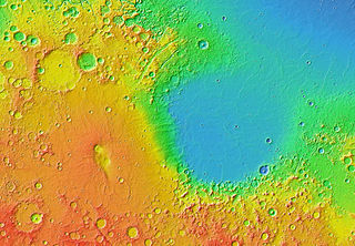
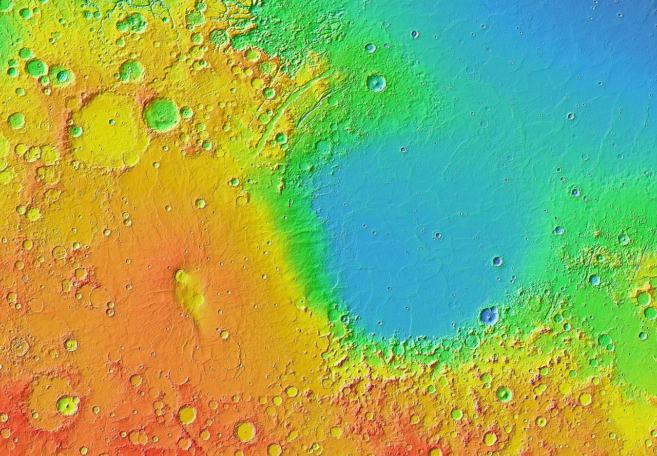
English: Mars Orbiter Laser Altimeter (MOLA) colorized topographic map showing the impact basin Isidis Planitia (right) and the broad, low-lying shield volcano Syrtis Major Planum (left), just north of the equator in the eastern hemisphere of Mars. Isidis is the third largest of the obvious impact basins on the planet. The calderas Nili Patera (upper left) and Meroe Patera (lower right) are visible within the central region of Syrtis Major. Some of the features in this image are annotated in Wikimedia Commons. |
| 日期 | |
| 來源 | JMARS |
| 作者 | NASA / JPL-Caltech / Arizona State University |
| 其他版本 |
 |
授權條款
| 本作品由NASA創作,屬於公有領域。根據NASA的版權政策:“NASA的創作除非另有聲明否則不受版權保護。”(參見:Template:PD-USGov/zh,NASA版權政策或JPL圖像使用政策) | ||
 |
警告:
|
| 註解 | 該圖片含有註解:在維基媒體共享資源上查看註解 |
檔案歷史
點選日期/時間以檢視該時間的檔案版本。
| 日期/時間 | 縮圖 | 尺寸 | 用戶 | 備註 | |
|---|---|---|---|---|---|
| 目前 | 2013年3月30日 (六) 07:04 | | 3,600 × 2,500(4.28 MB) | WolfmanSF | User created page with UploadWizard |
檔案用途
下列頁面有用到此檔案:
全域檔案使用狀況
以下其他 wiki 使用了這個檔案:
- ca.wikipedia.org 的使用狀況
- el.wikipedia.org 的使用狀況
- en.wikipedia.org 的使用狀況
- eo.wikipedia.org 的使用狀況
- fr.wikipedia.org 的使用狀況
- it.wikipedia.org 的使用狀況
- ja.wikipedia.org 的使用狀況
- uk.wikipedia.org 的使用狀況