
File:UN-Non-Self-Governing Territories.svg

原始檔案 (SVG 檔案,表面大小:683 × 363 像素,檔案大小:1.37 MB)
摘要
| 描述 |
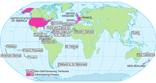
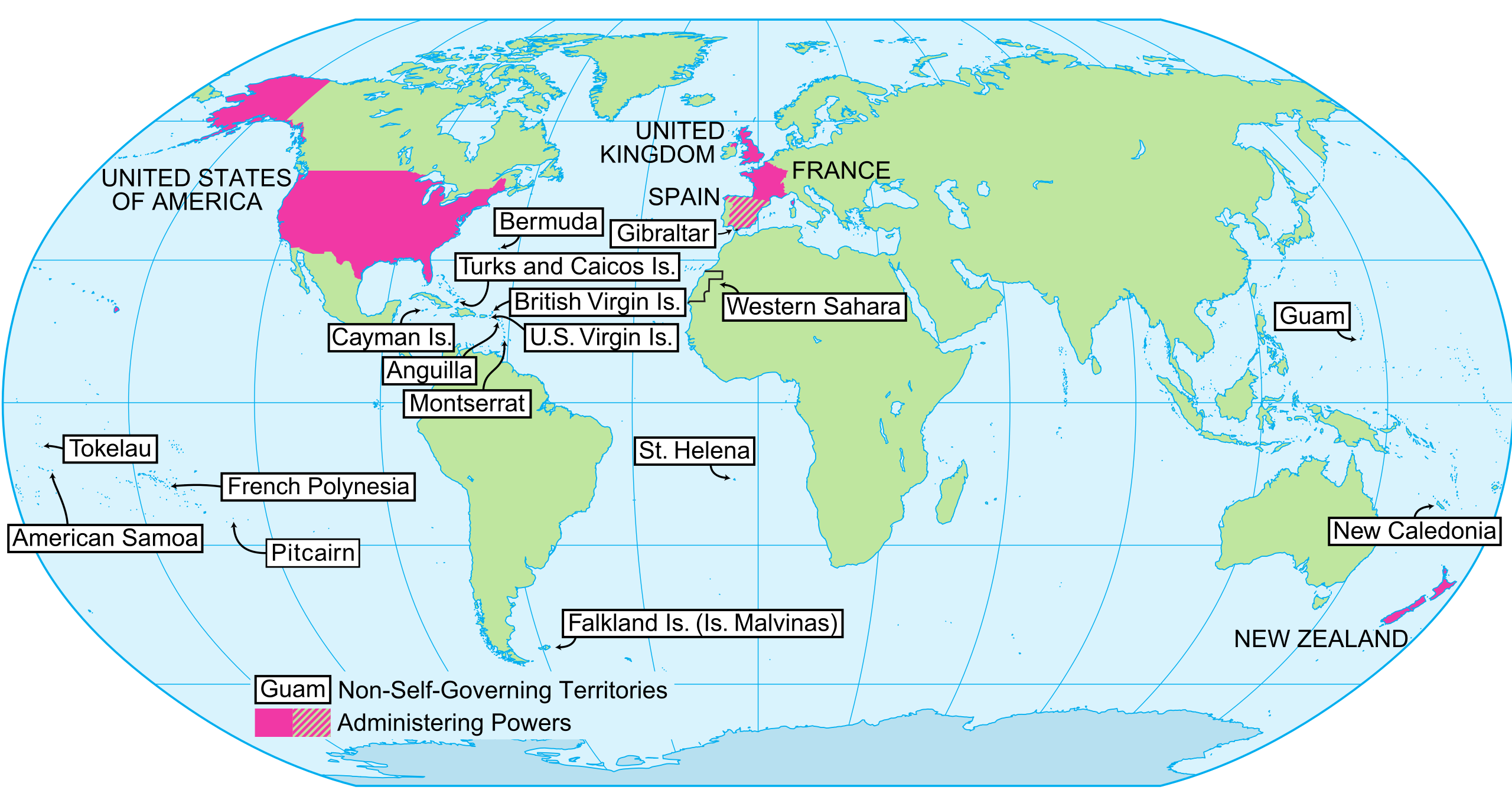
English: UN Map of Non-Self Governing Territories |
| 日期 | 日期不明, converted to svg date of upload |
| 來源 | Derived from UN Map of Non-Self Governing Territories[失效連結] |
| 作者 | United Nations Cartographic Section converted to SVG by User:RaviC |
| 其他版本 |
|

授權條款
| This image is a map derived from a United Nations map.
Unless stated otherwise, UN maps are to be considered in the public domain. This applies worldwide. UN maps are, in principle, open source material and you can use them in your work or for making your own map. UN requests however that you delete the UN name, logo and reference number upon any modification to the map. Content of your map will be your responsibility. You can state in your publication, if you wish, something like: based on UN map … (map name, map number, revision number and date). See: Geospatial Information Section. And: Geospatial, location data for a better world. |
 |
檔案歷史
點選日期/時間以檢視該時間的檔案版本。
| 日期/時間 | 縮圖 | 尺寸 | 用戶 | 備註 | |
|---|---|---|---|---|---|
| 目前 | 2022年7月15日 (五) 07:45 | | 683 × 363(1.37 MB) | Kwamikagami | add Pitcairn |
| 2021年8月9日 (一) 23:08 |  | 640 × 340(1.21 MB) | M.Bitton | Reverted to version as of 19:23, 9 July 2017 (UTC): Spain is the the territory's de jure administering power | |
| 2021年8月5日 (四) 02:45 |  | 683 × 363(1.37 MB) | Kwamikagami | Spain does not administer any NSG territories. Morocco does. | |
| 2017年7月9日 (日) 19:23 |  | 640 × 340(1.21 MB) | NordNordWest | + French Polynesia | |
| 2010年7月3日 (六) 00:20 |  | 640 × 340(1.93 MB) | Orange Tuesday | merging some continent paths | |
| 2010年7月2日 (五) 20:08 |  | 640 × 340(1.95 MB) | Orange Tuesday | Labels enlarged and text converted to paths so that the image is actually legible when used in an article. | |
| 2009年3月12日 (四) 07:40 |  | 642 × 343(1.63 MB) | RaviC | cropped | |
| 2008年11月22日 (六) 21:08 |  | 792 × 612(1.42 MB) | RaviC | {{Information |Description={{en|UN Map of Non-Self Governing Territories}} |Source=Derived from [http://www.un.org/Depts/Cartographic/map/profile/nonselfe.pdf UN Map of Non-Self Governing Territories] |Author=United Nations Cartographic Section converted |
檔案用途
下列頁面有用到此檔案:
全域檔案使用狀況
以下其他 wiki 使用了這個檔案:
- de.wikipedia.org 的使用狀況
- en.wikipedia.org 的使用狀況
- gl.wikipedia.org 的使用狀況
- it.wikipedia.org 的使用狀況
- ms.wikipedia.org 的使用狀況
- no.wikipedia.org 的使用狀況