
File:1853 Kaei 6 Japanese Map of the World - Geographicus - ChikyuBankokuHozu-nakajima-1853.jpg

預覽大小:800 × 466 像素。 其他解析度:320 × 186 像素 | 640 × 372 像素 | 1,024 × 596 像素 | 1,280 × 745 像素 | 2,560 × 1,490 像素 | 6,000 × 3,492 像素。
原始檔案 (6,000 × 3,492 像素,檔案大小:5.51 MB,MIME 類型:image/jpeg)
摘要
| Shintei - Chikyu Bankoku Hozu (Square Map of all the Countries on the Globe) | |||
|---|---|---|---|
| 作家 | |||
| 標題 |
Shintei - Chikyu Bankoku Hozu (Square Map of all the Countries on the Globe) |
||
| 描述 |
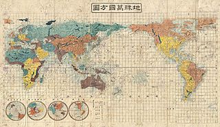
English: A very interesting 1853 (Kaei 6) Japanese world map by Suido Nakajima. Presented on a cylindrical projection, this map marks a significant advancement in Japanese globular cartography and a far more sophisticated adaptation of western cartographic standards than is evidenced in most earlier Japanese world maps. No longer reliant on 17th century Dutch maps acquired via the Dutch East India Company’s (VOC) trade concession in Nagasaki, the Japanese have here abandoned many of the antiquated cartographic notions, such as an insular California, which were common in Japanese maps of the previous decade. Japanese cartographers may have been motivated to update their traditional world view in the light of the explosion of cartographic ideas associated with the arrival in Edo Harbor of the American Commodore Matthew Perry in the same year this map was published. As a whole this map offers a sophisticated cartographic presentation of the world embracing the most up to date cartographic knowledge available in the mid-19th century. Though adapted to the Japanese printing style, this map presents a generally accurate world view. British Claims to Washington and British Columbia are noted in North America, Australia and the Pacific are accurately rendered, as are the discoveries of Vitus Bering and James Cook in the Arctic, and Africa is clearly pre-Speke. The disputed East Sea / Sea of Japan / Sea of Korea is here labeled as the Sea of Joseon (Korea), which some scholars suggests indicates Japanese acceptance of the “Sea of Korea” convention. Four hemispheres appear in the lower left quadrant, from left, the southern, northern, eastern, and western. All are on a stereographic projection. The map is printed on woodblock and hand colored in vivid, blues, greens, oranges, and yellows. A fine example of the redefined Japanese cartography style of the later Tokugawa period. |
||
| 日期 | 1853年 (dated Kaei 6) | ||
| 尺寸 | 高度:31英寸(78.7釐米);寬度:51英寸(129.5釐米) | ||
| 登錄號 |
Geographicus link: ChikyuBankokuHozu-nakajima-1853 |
||
| 來源/攝影者 |
|
||
授權條款
|
此為如實地拍攝平面藝術品的相片複製本。原作位於公有領域,是因下列原因:
維基媒體基金會的官方立場認為:「針對平面公有領域的藝術作品進行忠實重製,其重製後的照片也屬於公有領域。」
因此,可認定本重製照片屬於公有領域。在其他司法管轄區,再利用此照片可能會被限制;參見再利用PD-Art照片以獲得進一步資訊。 | ||||
檔案歷史
點選日期/時間以檢視該時間的檔案版本。
| 日期/時間 | 縮圖 | 尺寸 | 用戶 | 備註 | |
|---|---|---|---|---|---|
| 目前 | 2011年3月25日 (五) 05:07 | | 6,000 × 3,492(5.51 MB) | BotMultichillT | {{subst:User:Multichill/Geographicus |link=http://www.geographicus.com/P/AntiqueMap/ChikyuBankokuHozu-nakajima-1853 |product_name=1853 Kaei 6 Japanese Map of the World |map_title=Shintei - Chikyu Bankoku Hozu (Square Map of all the Countries on the Globe) |
檔案用途
下列頁面有用到此檔案: