跳至內容

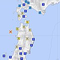
File:1983 Sea of Japan earthquake.jpg

頁面內容不支援其他語言。
這個檔案來自維基共享資源
維基百科,自由的百科全書

原始檔案(1,378 × 1,361 像素,檔案大小:485 KB,MIME 類型:image/jpeg


摘要

描述
English: Intensity map of 1983 Sea of Japan earthquake
日期
來源 https://www.data.jma.go.jp/svd/eqdb/data/shindo/index.html#19830526115957
作者 Japan Meteorological Agency

授權條款

This image was produced by the 氣象廳. The legal notice (archive) stated that all the images published on their website is compatible with the Creative Commons Attribution 4.0 License, which means that all the images on this website is published under the Creative Commons Attribution 4.0 License unless otherwise specified.

Government of Japan 本作品採用《日本國政府標準利用規約(2.0版)》授權。該許可協議和創用CC署名 4.0 國際許可協議兼容。查詢該作品的具體使用條款,請參見此許可頁面

English  español  日本語  한국어  македонски  русский  português  slovenščina  Tiếng Việt  简体中文‎  繁體中文‎  +/−

w:zh:共享創意
姓名標示
此檔案採用創用CC 姓名標示 4.0 國際授權條款。
姓名標示: 氣象廳
您可以自由:
  • 分享 – 複製、發佈和傳播本作品
  • 重新修改 – 創作演繹作品
惟需遵照下列條件:
  • 姓名標示 – 您必須指名出正確的製作者,和提供授權條款的連結,以及表示是否有對內容上做出變更。您可以用任何合理的方式來行動,但不得以任何方式表明授權條款是對您許可或是由您所使用。

說明

添加單行說明來描述出檔案所代表的內容
Intensity map of 1983 Sea of Japan earthquake

在此檔案描寫的項目

描繪內容

著作權狀態 繁體中文 (已轉換拼寫)

有著作權 繁體中文 (已轉換拼寫)

共享創意署名4.0國際 Chinese (Hong Kong) (已轉換拼寫)

多媒體型式 繁體中文 (已轉換拼寫)

image/jpeg

校驗和 繁體中文 (已轉換拼寫)

5d8b366843d4c5f97aa0cf42f1f0fb2cda7b98fd

斷定方法:​SHA-1 中文 (已轉換拼寫)

資料大小 Chinese (Hong Kong) (已轉換拼寫)

496,202 位元組

1,361 像素

1,378 像素

檔案歷史

點選日期/時間以檢視該時間的檔案版本。

日期/時間縮⁠圖尺寸用戶備⁠註
目前2021年7月25日 (日) 14:56於 2021年7月25日 (日) 14:56 版本的縮圖1,378 × 1,361(485 KB)Miamiaimchange style
2021年7月25日 (日) 14:54於 2021年7月25日 (日) 14:54 版本的縮圖1,704 × 1,359(606 KB)Miamiaimstyle
2021年7月19日 (一) 11:59於 2021年7月19日 (一) 11:59 版本的縮圖1,102 × 1,065(171 KB)MiamiaimUploaded a work by Japan Meteorological Agency from https://www.data.jma.go.jp/svd/eqdb/data/shindo/index.html#19830526115957 with UploadWizard

下列頁面有用到此檔案:

全域檔案使用狀況

以下其他 wiki 使用了這個檔案:

詮釋資料