
File:AS16-M-2995.jpg

預覽大小:600 × 600 像素。 其他解析度:240 × 240 像素 | 480 × 480 像素 | 1,012 × 1,012 像素。
原始檔案 (1,012 × 1,012 像素,檔案大小:584 KB,MIME 類型:image/jpeg)
摘要
| 描述 |
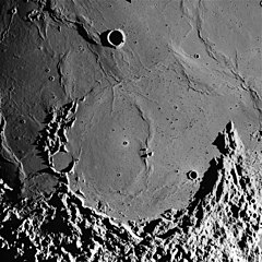
English: The flooded remnant of Letronne crater on the Moon can be seen in this image taken during the Apollo 16 mission. This photo was used in Figure 182 of Apollo Over the Moon: A View from Orbit (NASA SP-362, 1978), which has the following caption:
Photographic data:
|
| 日期 | |
| 來源 |
Original: Lunar & Planetary Institute, AS16-M-2995 Update: Arizona State University, Apollo Image Archive, Apollo Browse Gallery, Apollo 16: Mapping (Metric) Camera, AS16-M-2995 |
| 作者 | NASA |
本圖像或影音收錄於美國國家航空暨太空總署 (NASA)某部門,其照片編號為: AS16-M-2995 此標籤不表示文件的著作權狀態。任何文件在附有此標籤的同時還需要一個有效的著作權標籤。請參閱許可協議說明頁面以了解更多資訊。 其他語言:
|
授權條款
| 本作品由NASA創作,屬於公有領域。根據NASA的版權政策:“NASA的創作除非另有聲明否則不受版權保護。”(參見:Template:PD-USGov/zh,NASA版權政策或JPL圖像使用政策) | ||
 |
警告:
|
檔案歷史
點選日期/時間以檢視該時間的檔案版本。
| 日期/時間 | 縮圖 | 尺寸 | 用戶 | 備註 | |
|---|---|---|---|---|---|
| 目前 | 2019年9月21日 (六) 18:19 | | 1,012 × 1,012(584 KB) | Jstuby | higher resolution, from ASU |
| 2006年1月21日 (六) 18:15 |  | 598 × 600(73 KB) | RJHall | Letronne crater on the Moon. Image from Apollo 16. |
檔案用途
全域檔案使用狀況
以下其他 wiki 使用了這個檔案:
- cs.wikipedia.org 的使用狀況
- da.wikipedia.org 的使用狀況
- de.wikipedia.org 的使用狀況
- en.wikipedia.org 的使用狀況
- es.wikipedia.org 的使用狀況
- fa.wikipedia.org 的使用狀況
- ja.wikipedia.org 的使用狀況
- mk.wikipedia.org 的使用狀況
- pt.wikipedia.org 的使用狀況
- ro.wikipedia.org 的使用狀況
- ru.wikipedia.org 的使用狀況
- tr.wikipedia.org 的使用狀況