
File:Distribution of Indigenous Peoples in the Americas.svg

此 SVG 檔案的 PNG 預覽的大小:600 × 600 像素。 其他解析度:240 × 240 像素 | 480 × 480 像素 | 768 × 768 像素 | 1,024 × 1,024 像素 | 2,048 × 2,048 像素 | 3,200 × 3,200 像素。
原始檔案 (SVG 檔案,表面大小:3,200 × 3,200 像素,檔案大小:2.13 MB)
摘要
| 描述 |
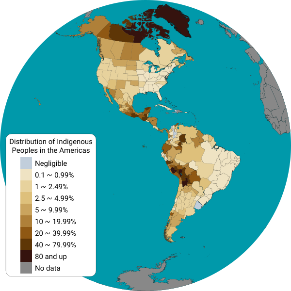
English: This map displays the distribution of indigenous people from each country in the Americas. Detailed information is displayed for Canadian provinces, U.S. states, Mexican states, Brazilian states and Chilean regions.
Map shapes from Natural Earth data, projected into a Lambert Azimuthal Equal-Area projection using a Python script. Data sources:
Español: Este mapa muestra el porcentaje de población indígena por cada país de América. Se muestra información detallada para las provincias de Canadá, los estados de los Estados Unidos, los estados de México, los estados de Brasil, los departamentos del Perú y de Bolivia, las provincias de la Argentina, y las regiones de Chile. |
| 日期 | |
| 來源 | 自己的作品 |
| 作者 | Locoluis |
授權條款
我,本作品的著作權持有者,決定用以下授權條款發佈本作品:
此檔案採用共享創意 姓名標示-相同方式分享 4.0 國際授權條款。
- 您可以自由:
- 分享 – 複製、發佈和傳播本作品
- 重新修改 – 創作演繹作品
- 惟需遵照下列條件:
- 姓名標示 – 您必須指名出正確的製作者,和提供授權條款的連結,以及表示是否有對內容上做出變更。您可以用任何合理的方式來行動,但不得以任何方式表明授權條款是對您許可或是由您所使用。
- 相同方式分享 – 如果您利用本素材進行再混合、轉換或創作,您必須基於如同原先的相同或兼容的條款,來分布您的貢獻成品。
檔案歷史
點選日期/時間以檢視該時間的檔案版本。
| 日期/時間 | 縮圖 | 尺寸 | 用戶 | 備註 | |
|---|---|---|---|---|---|
| 目前 | 2022年6月7日 (二) 02:03 | | 3,200 × 3,200(2.13 MB) | DemonDays64 | Converted text to Roboto path for consistent display. Also deleted the NOR path and removed some of the tiny dots of islands from NW Hawaii -- more border than anything and the NOR object was right on the edge making it look weird |
| 2021年9月16日 (四) 16:34 |  | 3,200 × 3,200(2.07 MB) | Abbasi786786 | 2020 US Census Update | |
| 2017年7月8日 (六) 18:53 |  | 3,200 × 3,200(6.58 MB) | Locoluis | Colombia https://www.dane.gov.co/files/censo2005/etnia/sys/visibilidad_estadistica_etnicos.pdf | |
| 2016年5月2日 (一) 06:06 |  | 1,600 × 1,600(6.4 MB) | Locoluis | Argentina | |
| 2016年3月14日 (一) 02:45 |  | 1,600 × 1,600(6.4 MB) | Locoluis | Added data for Peru and Bolivia | |
| 2015年3月29日 (日) 05:38 |  | 1,600 × 1,600(6.4 MB) | Locoluis | Broke Antarctica in the process... | |
| 2015年3月29日 (日) 04:56 |  | 1,600 × 1,600(6.52 MB) | Locoluis | * Fixed Canada * Added lakes * Added Brazil data from http://www.ibge.gov.br/indigenas/indigena_censo2010.pdf * Added another color category. | |
| 2015年3月29日 (日) 01:50 |  | 1,600 × 1,600(3.37 MB) | Locoluis | French Guiana, simplified redundant points, color scheme. | |
| 2015年3月29日 (日) 01:07 |  | 1,600 × 1,600(8.43 MB) | Locoluis | There was a CSS rule that displayed all US, CA, MX and CA regional polygons after all others were hidden. It didn't work. | |
| 2015年3月29日 (日) 01:02 |  | 1,600 × 1,600(8.43 MB) | Locoluis | Oops... |
檔案用途
下列頁面有用到此檔案:
全域檔案使用狀況
以下其他 wiki 使用了這個檔案:
- ar.wikipedia.org 的使用狀況
- ast.wikipedia.org 的使用狀況
- be.wikipedia.org 的使用狀況
- bg.wikipedia.org 的使用狀況
- ca.wikipedia.org 的使用狀況
- cs.wikipedia.org 的使用狀況
- de.wikipedia.org 的使用狀況
- en.wikipedia.org 的使用狀況
- eo.wikipedia.org 的使用狀況
- et.wikipedia.org 的使用狀況
- fi.wikipedia.org 的使用狀況
- fr.wikipedia.org 的使用狀況
- fy.wikipedia.org 的使用狀況
- ga.wikipedia.org 的使用狀況
- he.wikipedia.org 的使用狀況
- ia.wikipedia.org 的使用狀況
- id.wikipedia.org 的使用狀況
- ja.wikipedia.org 的使用狀況
- ko.wikipedia.org 的使用狀況
- ky.wikipedia.org 的使用狀況
- mk.wikipedia.org 的使用狀況
- oc.wikipedia.org 的使用狀況
- pt.wikipedia.org 的使用狀況
- ro.wikipedia.org 的使用狀況
- rue.wikipedia.org 的使用狀況
- sr.wikipedia.org 的使用狀況
- szy.wikipedia.org 的使用狀況
- tr.wikipedia.org 的使用狀況
- vec.wikipedia.org 的使用狀況
- vi.wikipedia.org 的使用狀況
- www.wikidata.org 的使用狀況