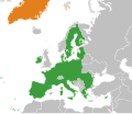
File:European Union Greenland Locator.svg
外觀

此 SVG 檔案的 PNG 預覽的大小:800 × 406 像素。 其他解析度:320 × 162 像素 | 640 × 325 像素 | 1,024 × 520 像素 | 1,280 × 650 像素 | 2,560 × 1,300 像素 | 2,754 × 1,398 像素。
原始檔案 (SVG 檔案,表面大小:2,754 × 1,398 像素,檔案大小:1.05 MB)
檔案歷史
點選日期/時間以檢視該時間的檔案版本。
| 日期/時間 | 縮圖 | 尺寸 | 用戶 | 備註 | |
|---|---|---|---|---|---|
| 目前 | 2022年1月24日 (一) 10:21 |  | 2,754 × 1,398(1.05 MB) | Saftorangen | use BlankMap-World.svg as template to show all affected areas |
| 2020年3月27日 (五) 09:38 |  | 1,981 × 1,701(641 KB) | Hogweard | Update | |
| 2014年7月29日 (二) 18:21 |  | 2,047 × 1,720(830 KB) | Masterdeis | +Croatia | |
| 2010年9月2日 (四) 14:17 |  | 2,047 × 1,720(870 KB) | Alvaro1984 18 | {{Information |Description={{en|1=The European Union and Greenland}} |Source=*File:European_Union_Israel_Locator.svg |Date=2010-09-02 14:15 (UTC) |Author=*File:European_Union_Israel_Locator.svg: Ssolbergj *derivative work: ~ | |
| 2010年5月14日 (五) 23:12 |  | 940 × 415(1.54 MB) | CGN2010 | {{Information |Description=European Union - Greenland locator map |Source={{own}} |Date=2010-05-15 |Author={{own}} |Permission={{PD-self}} |other_versions= }} Category:Bilateral maps of the European Union Category:maps of Greenland |
檔案用途
下列頁面有用到此檔案:
全域檔案使用狀況
以下其他 wiki 使用了這個檔案:
- da.wikipedia.org 的使用狀況
- en.wikipedia.org 的使用狀況
- es.wikipedia.org 的使用狀況
- et.wikipedia.org 的使用狀況
- fr.wikipedia.org 的使用狀況
- nl.wikipedia.org 的使用狀況
- ru.wikipedia.org 的使用狀況
- uk.wikipedia.org 的使用狀況
- www.wikidata.org 的使用狀況

