
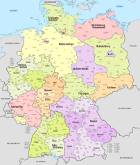
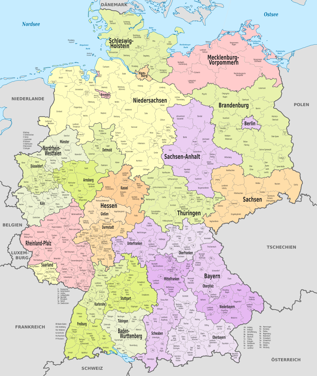
File:Germany, administrative divisions (+districts) - de - colored.svg

此 SVG 檔案的 PNG 預覽的大小:506 × 600 像素。 其他解析度:202 × 240 像素 | 405 × 480 像素 | 648 × 768 像素 | 864 × 1,024 像素 | 1,728 × 2,048 像素 | 1,073 × 1,272 像素。
原始檔案 (SVG 檔案,表面大小:1,073 × 1,272 像素,檔案大小:4.2 MB)
摘要
_location_map.svg)


.svg)


_(Paris_zoom).svg)
.svg)
,_administrative_divisions_-_de_-_colored_(multizoom).svg)
_-_colored.svg)
.svg)
,_administrative_divisions_-_Nmbrs_(multizoom).svg)
,_administrative_divisions_-_de_-_colored.svg)
_-_de_-_colored.svg)

.svg)

.svg)
_-_de_-_colored.svg?uselang=zh-mo)
_-_de_-_colored.svg?uselang=zh-mo)
_-_de_-_colored.svg?action=history&uselang=zh-mo)
_-_de_-_colored.svg)
授權條款
我,本作品的著作權持有者,決定用以下授權條款發佈本作品:
此檔案採用共享創意 姓名標示-相同方式分享 3.0 未在地化版本授權條款。
- 您可以自由:
- 分享 – 複製、發佈和傳播本作品
- 重新修改 – 創作演繹作品
- 惟需遵照下列條件:
- 姓名標示 – 您必須指名出正確的製作者,和提供授權條款的連結,以及表示是否有對內容上做出變更。您可以用任何合理的方式來行動,但不得以任何方式表明授權條款是對您許可或是由您所使用。
- 相同方式分享 – 如果您利用本素材進行再混合、轉換或創作,您必須基於如同原先的相同或兼容的條款,來分布您的貢獻成品。

|
已授權您依據自由軟體基金會發行的無固定段落、封面文字和封底文字GNU自由文件授權條款1.2版或任意後續版本,對本檔進行複製、傳播和/或修改。該協議的副本列在GNU自由文件授權條款中。 |
您可以選擇您需要的授權條款。

|
如果在維基百科或共享資源之外使用,您將此媒體檔案歸於維基共享資源,我將不勝感激。要在書籍、報紙、博客、網站等出版物中使用,請插入這以下行:
|
_-_de_-_colored.svg)
檔案歷史
點選日期/時間以檢視該時間的檔案版本。
| 日期/時間 | 縮圖 | 尺寸 | 用戶 | 備註 | |
|---|---|---|---|---|---|
| 目前 | 2021年12月7日 (二) 09:04 | | 1,073 × 1,272(4.2 MB) | TUBS | erlangen + höchstadt vereint |
| 2021年12月7日 (二) 08:46 |  | 1,073 × 1,272(4.15 MB) | TUBS | ||
| 2021年7月3日 (六) 19:56 |  | 1,073 × 1,272(6.08 MB) | NordNordWest | upd | |
| 2016年11月6日 (日) 14:12 |  | 1,073 × 1,272(6.05 MB) | NordNordWest | upd | |
| 2013年12月9日 (一) 16:28 |  | 1,073 × 1,272(6.02 MB) | TUBS | rv lass mal eine Version mit den ganzen Ebenen so. Hilft bei der Aktualisierung. Speicher deine neue (tolle) Version bitte unter anderem Namen | |
| 2013年12月9日 (一) 13:19 |  | 9,463 × 12,526(3.57 MB) | Mapmaster | Größer, weniger Ebenen | |
| 2013年12月9日 (一) 12:24 |  | 1,073 × 1,272(6.02 MB) | Mapmaster | Landkreis Kehlheim -> Niederbayern | |
| 2013年12月9日 (一) 11:35 |  | 1,073 × 1,272(6 MB) | Mapmaster | Landkreis Fulda -> Regierungsbezirk Kassel | |
| 2013年10月29日 (二) 13:07 |  | 1,073 × 1,272(5.98 MB) | TUBS | trischen>holstein | |
| 2013年10月29日 (二) 12:59 |  | 1,073 × 1,272(5.98 MB) | TUBS | == {{int:filedesc}} == {{Information |Description={{de|Karte der politischen Gliederung Deutschlands in Länder, Regierungsbezirke, Landkreise und krsfr. Städte}} {{en|Map of administrative divisions of Germany. States, government districts, districts... |
檔案用途
下列頁面有用到此檔案:
全域檔案使用狀況
以下其他 wiki 使用了這個檔案:
- ar.wikipedia.org 的使用狀況
- be.wikipedia.org 的使用狀況
- bg.wikipedia.org 的使用狀況
- de.wikipedia.org 的使用狀況
- de.wiktionary.org 的使用狀況
- el.wikipedia.org 的使用狀況
- en.wikipedia.org 的使用狀況
- fi.wikipedia.org 的使用狀況
- hu.wikipedia.org 的使用狀況
- ia.wikipedia.org 的使用狀況
- it.wikipedia.org 的使用狀況
- lb.wikipedia.org 的使用狀況
- mk.wikipedia.org 的使用狀況
- nl.wikipedia.org 的使用狀況
- ro.wikipedia.org 的使用狀況
- rue.wikipedia.org 的使用狀況
- sr.wikipedia.org 的使用狀況
- vec.wikipedia.org 的使用狀況
- www.wikidata.org 的使用狀況
_-_de_-_colored.svg)