
File:ITC Guillaume 19 feb 2002 0620Z.jpg

預覽大小:600 × 600 像素。 其他解析度:240 × 240 像素 | 480 × 480 像素 | 768 × 768 像素 | 1,024 × 1,024 像素 | 2,048 × 2,048 像素 | 5,200 × 5,200 像素。
原始檔案 (5,200 × 5,200 像素,檔案大小:4.16 MB,MIME 類型:image/jpeg)
摘要
| 描述 |
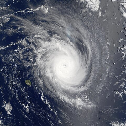
Projected to weaken over the coming day, Tropical Storm Guillaume was still going strong in the Indian Ocean in this Moderate Resolution Imaging Spectroradiometer (MODIS) image made from data acquired at 10:20 am local time on Tuesday, February 19, 2002. Shown here to the northeast of the French island of Réunion in the southwestern Indian Ocean off the coast of Madagascar, the outer bands of the storm clouds are obscuring the island of Mauritius, northeast of Réunion. The storm has been tracking slowly south-southeast, and should weaken as it moves farther south. As of Wednesday morning, February 20, maximum sustained winds were around 140 miles per hour (mph), with gusts of up to 167 mph. Waves were as high 24 ft. January and February are the peak cyclone months in the region, and Mauritius experiences on average about 10 each season. |
|||||
| 日期 | ||||||
| 來源 | http://visibleearth.nasa.gov/view_rec.php?id=2450 | |||||
| 作者 | Jacques Descloitres, MODIS Land Rapid Response Team, NASA/GSFC | |||||
| 授權許可 (重用此檔案) |
|
|||||
| 其他版本 | Image:TC Guillaume 19 feb 2002 0620Z.jpg |

檔案歷史
點選日期/時間以檢視該時間的檔案版本。
| 日期/時間 | 縮圖 | 尺寸 | 用戶 | 備註 | |
|---|---|---|---|---|---|
| 目前 | 2006年10月10日 (二) 21:06 | | 5,200 × 5,200(4.16 MB) | Good kitty | == Summary == {{Information |Description=Projected to weaken over the coming day, Tropical Storm Guillaume was still going strong in the Indian Ocean in this Moderate Resolution Imaging Spectroradiometer (MODIS) image made from data acquired at 10:20 am l |
檔案用途
下列頁面有用到此檔案:
全域檔案使用狀況
以下其他 wiki 使用了這個檔案:
- ca.wikipedia.org 的使用狀況
- en.wikipedia.org 的使用狀況