
File:Inland Niger Delta 2007.jpg
預覽大小:691 × 599 像素。 其他解析度:277 × 240 像素 | 554 × 480 像素 | 886 × 768 像素 | 1,024 × 888 像素。
原始檔案 (1,024 × 888 像素,檔案大小:167 KB,MIME 類型:image/jpeg)
摘要
| 描述 |
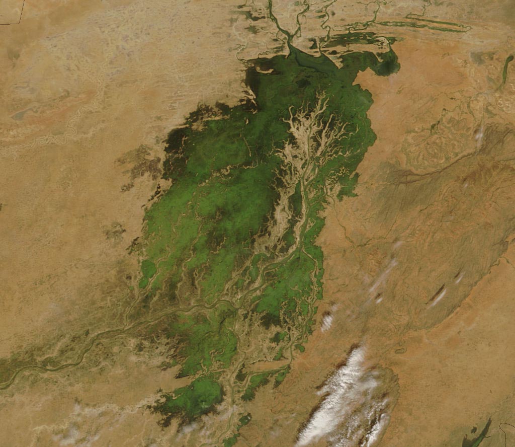
The MODIS on the Terra satellite took this picture of the Inland Niger Delta on November 11, 2007 shortly after the end of the rainy season when the landscape remained lush and green. This inland delta is a complex combination of river channels, lakes, swamps, and occasional areas of higher elevation. One such area of higher elevation is obvious in this image, and it forms a branching shape, like a tan tree pushing up toward the north. This wet oasis in the African Sahel provides habitat both for migrating birds and West African manatees. The fertile floodplains also provide much needed resources for the local people, who use the area for fishing, grazing livestock, and cultivating rice. |
| 日期 | |
| 來源 | http://modis.gsfc.nasa.gov/gallery/images/image11272007_250m.jpg |
| 作者 | Jeff Schmaltz, MODIS Land Rapid Response Team, NASA GSFC |
授權條款
| 本作品由NASA創作,屬於公有領域。根據NASA的版權政策:“NASA的創作除非另有聲明否則不受版權保護。”(參見:Template:PD-USGov/zh,NASA版權政策或JPL圖像使用政策) | ||
 |
警告:
|
檔案歷史
點選日期/時間以檢視該時間的檔案版本。
| 日期/時間 | 縮圖 | 尺寸 | 用戶 | 備註 | |
|---|---|---|---|---|---|
| 目前 | 2007年11月30日 (五) 00:36 | | 1,024 × 888(167 KB) | Pmsyyz | {{Information |Description= en:Niger Inland Delta |Source= http://modis.gsfc.nasa.gov/gallery/images/image11272007_250m.jpg |Date= 2007-11-27 |Author= Jeff Schmaltz, MODIS Land Rapid Response Team, NASA GSFC |Permission= |other_versions= }} |
檔案用途
下列頁面有用到此檔案:
全域檔案使用狀況
以下其他 wiki 使用了這個檔案:
- ar.wikipedia.org 的使用狀況
- ca.wikipedia.org 的使用狀況
- cs.wikipedia.org 的使用狀況
- de.wikipedia.org 的使用狀況
- en.wikipedia.org 的使用狀況
- eo.wikipedia.org 的使用狀況
- es.wikipedia.org 的使用狀況
- fr.wikipedia.org 的使用狀況
- ig.wikipedia.org 的使用狀況
- it.wikipedia.org 的使用狀況
- ja.wikipedia.org 的使用狀況
- lt.wikipedia.org 的使用狀況
- nn.wikipedia.org 的使用狀況
- pt.wikipedia.org 的使用狀況
- vi.wikipedia.org 的使用狀況
- www.wikidata.org 的使用狀況