
File:Oppida map 2.jpg
預覽大小:800 × 541 像素。 其他解析度:320 × 216 像素 | 640 × 433 像素 | 1,093 × 739 像素。
原始檔案 (1,093 × 739 像素,檔案大小:374 KB,MIME 類型:image/jpeg)
摘要
| 描述 |
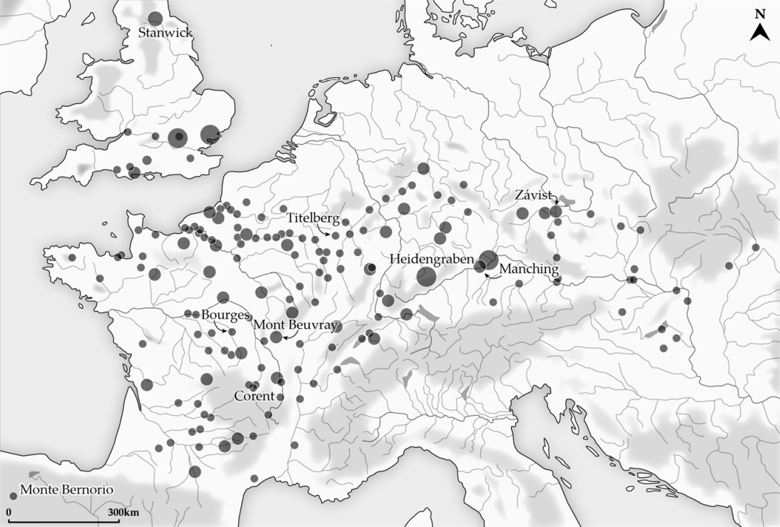
English: Distribution of fortified oppida with indication of some of the main sites, second–first centuries BC |
| 日期 | |
| 來源 |
Fernández-Götz, M. Urbanization in Iron Age Europe: Trajectories, Patterns, and Social Dynamics. J Archaeol Res 26, 117–162 (2018). https://doi.org/10.1007/s10814-017-9107-1 Licence: https://link.springer.com/article/10.1007/s10814-017-9107-1#rightslink |
| 作者 | Fernández-Götz, M. (2018) |
授權條款
此檔案採用共享創意 姓名標示-相同方式分享 4.0 國際授權條款。
- 您可以自由:
- 分享 – 複製、發佈和傳播本作品
- 重新修改 – 創作演繹作品
- 惟需遵照下列條件:
- 姓名標示 – 您必須指名出正確的製作者,和提供授權條款的連結,以及表示是否有對內容上做出變更。您可以用任何合理的方式來行動,但不得以任何方式表明授權條款是對您許可或是由您所使用。
- 相同方式分享 – 如果您利用本素材進行再混合、轉換或創作,您必須基於如同原先的相同或兼容的條款,來分布您的貢獻成品。
檔案歷史
點選日期/時間以檢視該時間的檔案版本。
| 日期/時間 | 縮圖 | 尺寸 | 用戶 | 備註 | |
|---|---|---|---|---|---|
| 目前 | 2023年1月23日 (一) 14:31 | | 1,093 × 739(374 KB) | Ario1234 | Uploaded a work by Fernández-Götz, M. (2018) from https://www.pure.ed.ac.uk/ws/portalfiles/portal/42324611/Fernandez_Gotz_Urbanization_in_Iron_Age_Europe_Journal_of_Archaeological_Research.pdf Fernández-Götz, M. Urbanization in Iron Age Europe: Trajectories, Patterns, and Social Dynamics. J Archaeol Res 26, 117–162 (2018). https://doi.org/10.1007/s10814-017-9107-1 Licence: https://link.springer.com/article/10.1007/s10814-017-9107-1#rightslink with UploadWizard |
檔案用途
下列頁面有用到此檔案:
全域檔案使用狀況
以下其他 wiki 使用了這個檔案:
- en.wikipedia.org 的使用狀況