
File:Plan of St. Lucia, in the West Indies- Shewing the positions of the English and French forces with the attacks made at its reduction in Decr. 1778. LOC 74696150.jpg

預覽大小:800 × 598 像素。 其他解析度:320 × 239 像素 | 640 × 479 像素 | 1,024 × 766 像素 | 1,280 × 957 像素 | 2,560 × 1,915 像素 | 3,107 × 2,324 像素。
原始檔案 (3,107 × 2,324 像素,檔案大小:3.17 MB,MIME 類型:image/jpeg)
摘要
| 描述 |
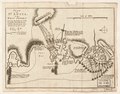
English: Scale ca. 1:51,000. Relief shown by hachures. Oriented with north to the left. Shows attacks made on Dec. 13-Dec. 16. Includes descriptive text. LC Maps of North America, 1750-1789, 2073 Available also through the Library of Congress Web site as a raster image. Vault AACR2: 651/1; 651/2 |
||
| Title | Plan of St. Lucia, in the West Indies: Shewing the positions of the English and French forces with the attacks made at its reduction in Decr. 1778. | ||
| Shelf ID | G5111.S2 1778 .B6 | ||
| 日期 | |||
| 來源 | https://www.loc.gov/item/74696150/ | ||
| 作者 | Bowen, Thomas | ||
| 授權許可 (重用此檔案) |
|
||
| 其他版本 |
|
||
| Location | Saint Lucia. · Saint Lucia | ||
| Part of | Military Battles And Campaigns · American Memory · Catalog · Geography And Map Division · American Revolution And Its Era: Maps And Charts Of North America And The West Indies, 1750-1789 | ||
| Subject | Saint Lucia, Battle Of, Saint Lucia · Maps · Early Works To 1800 · Saint Lucia · History |


授權條款
|
此為如實地拍攝平面藝術品的相片複製本。原作位於公有領域,是因下列原因:
維基媒體基金會的官方立場認為:「針對平面公有領域的藝術作品進行忠實重製,其重製後的照片也屬於公有領域。」
因此,可認定本重製照片屬於公有領域。在其他司法管轄區,再利用此照片可能會被限制;參見再利用PD-Art照片以獲得進一步資訊。 | ||||
檔案歷史
點選日期/時間以檢視該時間的檔案版本。
| 日期/時間 | 縮圖 | 尺寸 | 用戶 | 備註 | |
|---|---|---|---|---|---|
| 目前 | 2023年1月7日 (六) 20:47 | | 3,107 × 2,324(3.17 MB) | PawełMM | Cropped 3 % horizontally, 7 % vertically using CropTool with lossless mode. The tatty edges removed. |
| 2023年1月6日 (五) 07:23 |  | 3,190 × 2,495(3.31 MB) | PawełMM | cleaned, border removed | |
| 2018年12月16日 (日) 00:55 |  | 3,296 × 2,584(1.3 MB) | Fæ | LOC Maps https://www.loc.gov/item/74696150/ #9214 |
檔案用途
下列頁面有用到此檔案:
全域檔案使用狀況
以下其他 wiki 使用了這個檔案:
- en.wikipedia.org 的使用狀況
- he.wikipedia.org 的使用狀況