
File:US Overflight Fee Map.png
此為最大尺寸。
US_Overflight_Fee_Map.png (375 × 272 像素,檔案大小:28 KB,MIME 類型:image/png)
摘要
| 描述 |
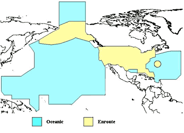
English: A map of the regions where the United States charges overflight fees. Yellow is where higher "enroute" fees are charged. Blue is where "oceanic" fees are charged. The colored regions of this map correspond to the regions where the US has delegated authority by the ICAO to control air traffic, including over international waters. |
| 日期 | 日期不明 |
| 來源 | http://www.faa.gov/about/office_org/headquarters_offices/aba/overflight_fees/ |
| 作者 | Federal Aviation Administration |
授權條款
|
|
 |
檔案歷史
點選日期/時間以檢視該時間的檔案版本。
| 日期/時間 | 縮圖 | 尺寸 | 用戶 | 備註 | |
|---|---|---|---|---|---|
| 目前 | 2014年8月9日 (六) 02:52 | | 375 × 272(28 KB) | AHeneen | User created page with UploadWizard |
檔案用途
下列頁面有用到此檔案:
全域檔案使用狀況
以下其他 wiki 使用了這個檔案:
- af.wikipedia.org 的使用狀況
- en.wikipedia.org 的使用狀況
- fr.wikipedia.org 的使用狀況
- it.wikipedia.org 的使用狀況
- ja.wikipedia.org 的使用狀況