
File:VITC Hary 08 mar 2002 0700Z.jpg

預覽大小:458 × 599 像素。 其他解析度:183 × 240 像素 | 367 × 480 像素 | 587 × 768 像素 | 783 × 1,024 像素 | 1,566 × 2,048 像素 | 5,200 × 6,800 像素。
原始檔案 (5,200 × 6,800 像素,檔案大小:3.68 MB,MIME 類型:image/jpeg)
摘要
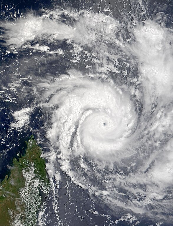
| 描述 | Tropical Cyclone Hary can be seen bearing down on Madagascar in this true-color image taken on March 8, 2002, at 7:00 UTC by the Moderate-resolution Imaging Spectroradiometer (MODIS), flying aboard NASA's Terra spacecraft. The cyclone, which came out of the east, hit the northern tip of Madagascar today before turning south and moving along the eastern shore of the island. At the time this image was taken, the cyclone carried sustained winds of roughly 222 kilometers (138 miles) per hour and gusts of up to 269 kilometers (167 miles) per hour. | |||||
| 日期 | ||||||
| 來源 | http://earthobservatory.nasa.gov/NaturalHazards/view.php?id=9247 | |||||
| 作者 | Image courtesy Jacques Descloitres, MODIS Land Rapid Response Team at NASA GSFC | |||||
| 授權許可 (重用此檔案) |
|

檔案歷史
點選日期/時間以檢視該時間的檔案版本。
| 日期/時間 | 縮圖 | 尺寸 | 用戶 | 備註 | |
|---|---|---|---|---|---|
| 目前 | 2013年5月6日 (一) 05:25 | | 5,200 × 6,800(3.68 MB) | Earth100 | Enhanced. |
| 2006年10月10日 (二) 21:08 |  | 5,200 × 6,800(3.95 MB) | Good kitty | == Summary == {{Information |Description=Tropical Cyclone Hary can be seen bearing down on Madagascar in this true-color image taken on March 8, 2002, at 7:00 UTC by the Moderate-resolution Imaging Spectroradiometer (MODIS), flying aboard NASA's Terra spa |
檔案用途
下列16個頁面有用到此檔案:
- 2001—2002年西南印度洋热带气旋季
- 气旋哈利
- Talk:气旋哈利
- Wikipedia:优良条目/2015年4月
- Wikipedia:优良条目/2015年4月21日
- Wikipedia:优良条目/气旋哈利
- Wikipedia:典范条目/2015年4月
- Wikipedia:典范条目/2015年4月1日
- Wikipedia:典范条目/2017年5月
- Wikipedia:典范条目/2017年5月16日
- Wikipedia:典范条目/2019年12月
- Wikipedia:典范条目/2019年12月7日
- Wikipedia:典范条目/2023年11月
- Wikipedia:典范条目/2023年11月30日
- Wikipedia:典范条目/气旋哈利
- Wikipedia:潜在优良和典范话题
全域檔案使用狀況
以下其他 wiki 使用了這個檔案:
- en.wikipedia.org 的使用狀況
- Portal:Tropical cyclones/Anniversaries/March
- Portal:Tropical cyclones/Anniversaries/March/10
- 2001–02 South-West Indian Ocean cyclone season
- Wikipedia:Good topics
- Cyclone Hary
- Wikipedia:Today's featured article/March 2015
- Wikipedia:Featured and good topic candidates/2001–02 South-West Indian Ocean cyclone season/archive1
- Wikipedia:Featured and good topic candidates/Featured log/May 2013
- Wikipedia:Featured and good topic candidates/Good log/May 2013
- Wikipedia:Featured topics/2001–02 South-West Indian Ocean cyclone season
- Wikipedia:Today's featured article/March 20, 2015
- Wikipedia:Main Page history/2015 March 20
- Tropical cyclones in 2002