
File:Ash Plume from Tavurvur, Papua New Guinea.jpg

本预览的尺寸:534 × 599像素。 其他分辨率:214 × 240像素 | 428 × 480像素 | 685 × 768像素 | 1,183 × 1,327像素。
原始文件 (1,183 × 1,327像素,文件大小:241 KB,MIME类型:image/jpeg)
摘要
| 描述 |
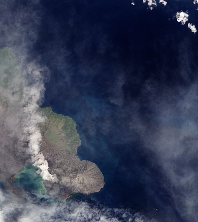
English: A 1994 eruption which buried Rabaul involved the currently active Tavurvur Cone as well as Vulcan Cone, located across Blanche Bay to the south-west (not pictured). The city of Rabaul is located on the peninsula across the Great Harbor from Tavurvur. More than a foot of ash fell on parts of the city, and combined with rain, it collapsed many of the small city’s buildings and houses. White dots on the peninsula may be buildings or building sites. |
| 日期 | |
| 来源 | NASA Earth Observatory |
| 作者 | Robert Simmon |
Image captured by the Advanced Land Imager on NASA’s Earth Observing-1 (EO-1) satellite. Image created using EO-1 ALI data provided by the NASA EO-1 team. Instrument: EO-1 - ALI
许可协议
| 本文件完全由NASA创作,在美国属于公有领域。根据NASA的版权方针,NASA的材料除非另有声明否则不受版权保护。(参见Template:PD-USGov/zh、NASA版权方针页面或JPL图片使用方针。) | ||
 |
警告:
|
| 注解 | 该图片含有注解:在维基媒体共享资源上查看注解 |
文件历史
点击某个日期/时间查看对应时刻的文件。
| 日期/时间 | 缩略图 | 大小 | 用户 | 备注 | |
|---|---|---|---|---|---|
| 当前 | 2009年12月8日 (二) 13:04 | | 1,183 × 1,327(241 KB) | Originalwana | {{Information |Description={{en|1=A 1994 eruption which buried Rabaul involved the currently active Tavurvur Cone as well as Vulcan Cone, located across Blanche Bay to the south-west (not pictured). The city of Rabaul is located on the peninsula acros |
文件用途
以下页面使用本文件:
全域文件用途
以下其他wiki使用此文件:
- br.wikipedia.org上的用途
- en.wikipedia.org上的用途
- fa.wikipedia.org上的用途
- hu.wikipedia.org上的用途
- id.wikipedia.org上的用途
- it.wikipedia.org上的用途
- ja.wikipedia.org上的用途
- ko.wikipedia.org上的用途
- pt.wikipedia.org上的用途
- uk.wikipedia.org上的用途