
File:Atchafalaya Basin.jpg

預覽大小:800 × 534 像素。 其他解析度:320 × 214 像素 | 640 × 427 像素 | 1,024 × 683 像素 | 1,500 × 1,001 像素。
原始檔案 (1,500 × 1,001 像素,檔案大小:648 KB,MIME 類型:image/jpeg)
| 描述 |
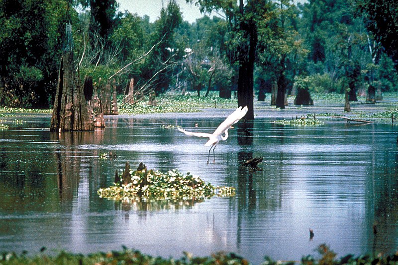
English: A scene in the Atchafalaya Basin in Louisiana, USA, in the Sherburne Complex Wildlife Management Area, a Nature Conservancy reserve. |
|||
| 日期 | not specified or unknown | |||
| 來源 |
U.S. Army Corps of Engineers Digital Visual Library Image page Image description page Digital Visual Library home page |
|||
| 作者 | U.S. Army Corps of Engineers, photographer not specified or unknown | |||
| 授權許可 (重用此檔案) |
|
|||
| 圖中地點 | Atchafalaya Basin, Louisiana, USA |
| 拍攝地點 | | 位於此地的本圖片與其他圖片: OpenStreetMap |
|---|
檔案歷史
點選日期/時間以檢視該時間的檔案版本。
| 日期/時間 | 縮圖 | 尺寸 | 使用者 | 備註 | |
|---|---|---|---|---|---|
| 目前 | 2007年4月1日 (日) 05:14 | | 1,500 × 1,001(648 KB) | DanMS | {{Information | Description = {{en|A scene in the Atchafalaya Basin in Louisiana, USA.}} | Source = U.S. Army Corps of Engineers Digital Visual Library<br />[http://images.usace.army.mil/images/Hires/0655-12.jpg Image page]<br />[http://images. |
檔案用途
下列頁面有用到此檔案:
全域檔案使用狀況
以下其他 wiki 使用了這個檔案:
- bo.wikipedia.org 的使用狀況
- ca.wikipedia.org 的使用狀況
- ceb.wikipedia.org 的使用狀況
- de.wikipedia.org 的使用狀況
- eml.wikipedia.org 的使用狀況
- en.wikipedia.org 的使用狀況
- Louisiana
- Oasis
- Ecoregion
- Peter Scott
- Muskeg
- Mangrove
- Estuary
- Lagoon
- Swamp
- Peat
- Wetland
- Wildfowl & Wetlands Trust
- WWT Caerlaverock
- Fen
- WWT Arundel
- Castle Espie
- WWT London Wetland Centre
- WWT Llanelli Wetlands Centre
- WWT Martin Mere
- WWT Slimbridge
- WWT Washington
- Limnology
- Bog
- Lake Agassiz
- Ouse Washes
- Aquatic plant
- Will-o'-the-wisp
- River delta
- Marsh
- Drainage basin
- Ramsar Convention
- Flooded grasslands and savannas
- Tigris–Euphrates river system
- Salt marsh
- Aquatic animal
- Waterkeeper Alliance
- Sapric
- Sudd
- Oxbow lake
- Lake Bangweulu
- Okavango Delta
- Lake Mweru Wantipa
- Mudflat
- Moorland
檢視此檔案的更多全域使用狀況。