
File:China 1936.png
此為最大尺寸。
China_1936.png (120 × 131 像素,檔案大小:13 KB,MIME 類型:image/png)
摘要
| 描述 |
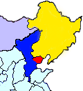
English: This map shows the territory controlled by the Hebei-Chahar Political Council (blue), the East Hebei Anti-Communist Autonomous Government (red), Manchukuo (yellow), and Mongolia (grey) at the end of 1935 and the beginning of 1936. As noted on Wikipedia, the Hebei-Chahar Political Council controlled the provinces of Chahar and Hebei except for the portion of Hebei Province occuped by the East Hebei Anti-Communist Autonomous Government, which, as noted by Paul French in The Old Shanghai A-Z and other sources, controlled the 22 northeastern counties of Hebei Province running along the Great Wall and south into the demilitarized zone almost as far south as Beijing and Tianjin.
Although this is a crude map based off "File:ROC-Chahar.png", there are several articles in severe need of some sort of geographic illustration, |
| 日期 | |
| 來源 | 自己的作品 |
| 作者 | CurtisNaito |
授權條款
我,本作品的著作權持有者,決定用以下授權條款發佈本作品:
此檔案採用創用CC 姓名標示-相同方式分享 3.0 未在地化版本授權條款。
- 您可以自由:
- 分享 – 複製、發佈和傳播本作品
- 重新修改 – 創作演繹作品
- 惟需遵照下列條件:
- 姓名標示 – 您必須指名出正確的製作者,和提供授權條款的連結,以及表示是否有對內容上做出變更。您可以用任何合理的方式來行動,但不得以任何方式表明授權條款是對您許可或是由您所使用。
- 相同方式分享 – 如果您利用本素材進行再混合、轉換或創作,您必須基於如同原先的相同或兼容的條款,來分布您的貢獻成品。
檔案歷史
點選日期/時間以檢視該時間的檔案版本。
| 日期/時間 | 縮圖 | 尺寸 | 使用者 | 備註 | |
|---|---|---|---|---|---|
| 目前 | 2012年10月18日 (四) 23:27 | | 120 × 131(13 KB) | CurtisNaito | User created page with UploadWizard |
檔案用途
下列頁面有用到此檔案:
全域檔案使用狀況
以下其他 wiki 使用了這個檔案:
- en.wikipedia.org 的使用狀況
- es.wikipedia.org 的使用狀況
- ja.wikipedia.org 的使用狀況
- ko.wikipedia.org 的使用狀況
- nl.wikipedia.org 的使用狀況
- uk.wikipedia.org 的使用狀況
- www.wikidata.org 的使用狀況