
File:Hall Islands Landsat.jpg

預覽大小:800 × 449 像素。 其他解析度:320 × 179 像素 | 640 × 359 像素 | 1,200 × 673 像素。
原始檔案 (1,200 × 673 像素,檔案大小:140 KB,MIME 類型:image/jpeg)
摘要
| 描述 |
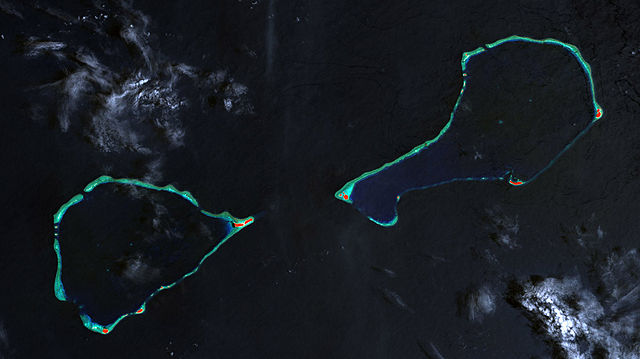
Deutsch: Landsat-7-Bild der Hall-Inseln, bestehend aus den Atollen Nomwin (links) und Murilo (rechts), Staat Chuuk, Föderierte Staaten von Mikronesien
English: Landsat 7 image of Hall Islands which consist of the two atolls Nowin (left) and Murilo (right), Chuuk State, Federated States of Micronesia |
| 日期 | |
| 來源 | http://www.oceandots.com/pacific/caroline/murilo3.php |
| 作者 | NASA millenium coral reefs landsat archive |
授權條款
| 本作品由NASA創作,屬於公有領域。根據NASA的版權政策:“NASA的創作除非另有聲明否則不受版權保護。”(參見:Template:PD-USGov/zh,NASA版權政策或JPL圖像使用政策) | ||
 |
警告:
|
| 註解 | 該圖片含有註解:在維基媒體共享資源上查看註解 |
檔案歷史
點選日期/時間以檢視該時間的檔案版本。
| 日期/時間 | 縮圖 | 尺寸 | 使用者 | 備註 | |
|---|---|---|---|---|---|
| 目前 | 2010年1月30日 (六) 19:36 | | 1,200 × 673(140 KB) | Telim tor | == {{int:filedesc}} == {{Information |Description= {{de|Landsat-7-Bild der Hall-Inseln, bestehend aus den Atollen Nomwin (links) und Murilo (rechts), Staat Chuuk, Föderierte Staaten von Mikronesien}} {{en|Landsat 7 image of Hall Islands which consist of |
檔案用途
下列頁面有用到此檔案:
全域檔案使用狀況
以下其他 wiki 使用了這個檔案:
- de.wikipedia.org 的使用狀況
- en.wikipedia.org 的使用狀況
- es.wikipedia.org 的使用狀況
- fa.wikipedia.org 的使用狀況
- fr.wikipedia.org 的使用狀況
- ja.wikipedia.org 的使用狀況
- lv.wikipedia.org 的使用狀況
- mk.wikipedia.org 的使用狀況
- tr.wikipedia.org 的使用狀況
- www.wikidata.org 的使用狀況